Orocovis, Puerto Rico
Orocovis (from Taino language, Orocobix meaning remembrance of the first mountain) is a municipality of Puerto Rico located in the Central Mountain Range, north of Villalba and Coamo; south of Morovis and Corozal; southeast of Ciales; east of Jayuya; and west of Barranquitas. Orocovis is spread over 17 wards and Orocovis Pueblo (the downtown area and the administrative center of the city). It is part of the San Juan-Caguas-Guaynabo Metropolitan Statistical Area.
Orocovis Municipio de Orocovis | |
|---|---|
Town and Municipality | |
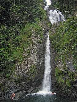 Salto de Doña Juana waterfall in Orocovis | |
 Flag | |
| Nicknames: "Corazón de Puerto Rico", "El Centro Geográfico de Puerto Rico" | |
| Anthem: "Mi patria es una bella isla" | |
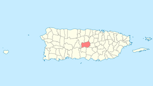 Map of Puerto Rico highlighting Orocovis Municipality | |
| Coordinates: 18°13′37″N 66°23′28″W | |
| Commonwealth | |
| Founded | November 10, 1825 |
| Wards | |
| Government | |
| • Mayor | Jesús E. Colón Berlingeri (PNP) |
| • Senatorial dist. | 5 - Ponce |
| • Representative dist. | 26 |
| Area | |
| • Total | 71.1 sq mi (184.17 km2) |
| • Land | 71.0 sq mi (184 km2) |
| • Water | 0.1 sq mi (0.17 km2) |
| Population (2010) | |
| • Total | 23,423 |
| • Density | 330/sq mi (130/km2) |
| Demonym(s) | Orocoveños |
| Time zone | UTC-4 (AST) |
| ZIP Code | 00720 |
| Area code(s) | 787/939 |
| Major routes | |
| Website | www |

History
Since before the Spanish colonization in the 16th century, Taíno Indians were already established in the Orocovis region. They were led by the cacique Orocobix and his group of Taino was known as the Jatibonicu. After Spaniards settled in the island, the region was called Barros and designated as a barrio of Barranquitas.
On May 25, 1825, the neighbors of the region granted Don Juan de Rivera Santiago the powers to request the Governor authorization to found a municipality in Barros, where they had bought almost 14 acres of land from Doña Eulalia de Rivera, who donated an additional acre to establish several municipal works. However, due to the distance from bodies of water, the settlement was moved to another place. On November 10, 1825, Governor Miguel de la Torre granted permission to found the new municipality of Barros.
In 1838, the parish of San Juan Bautista de Barros was created and was blessed and inaugurated on October 29 of the same year. However, on 1875, a fire destroyed the church, the King's House, the priest's house and several homes.
In 1928, the Legislative Assembly of Puerto Rico approved a resolution to change the name of Barros to Orocovis, to honor the Taíno cacique of the same name, who lived in that region.
Hurricane Maria
.jpg)
Hurricane Maria on September 20, 2017, triggered numerous landslides in Orocovis due to significant rainfall.[1][2]
Carmen Maldonado, the mayor of Morovis, a bordering municipality, spoke to New York governor Andrew Cuomo, requesting his help and Cuomo responded by contacting H.e.a.r.t. 9/11, a non-profit organization. In early 2019, Maldonado received and thanked volunteers from H.e.a.r.t. 9/11, mostly carpenters who came to Morovis to repair and rebuild homes damaged by the hurricane. In mid-June, 2019 the group of H.e.a.r.t. 9/11 volunteers, along with volunteers in Puerto Rico continued their work, including building the roofs of many homes in Orocovis.[3][4][5]
Symbol
Flag of Orocovis
The Flag of Orocovis is formed by five vertical stripes: Two green stripes at the ends, representing the territories of Aibonito and Barranquitas; and a blue one in the center representing the regional domain of the cacique Orocobix prior to the Spanish colonization. These stripes are divided by two narrower white stripes, representing the territories granted by Barranquitas and Morovis to form the municipality in 1825.
Over the blue portion there's an oval with a sun. The sun has seventeen rays that represent the different regions of the town. The sun, being the center of our solar system, represents Orocovis as the center of the island of Puerto Rico.
Coat of arms
The oval is symbol of the letter "O", initial of the name of the town. In each quadrant appear representative elements of the town. In the left superior quadrant a Taíno Indian bust, symbol of the great "Chief Orocobix" and the Indian heritage of the town, silhouetted in gold on a silver-plated background. The Indian bust faces towards the star or sun that appears in the superior right quadrant, which is in gold on a blue background and represents the territorial municipality with its seventeen rays or demarcations. In the inferior right quadrant, a plantain plant is observed representing the agriculture, silhouetted in gold on a silver-plated background. A bridge also silhouetted in gold on a blue background, above the river appears in the left inferior quadrant.
Nicknames
Most of Orocovis nicknames stem from its location in the center of the island. Some of them are: "Corazón de Puerto Rico" (Heart of Puerto Rico) and "Centro Geográfico de Puerto Rico" (Geographical Center of Puerto Rico). The center of the island of Puerto Rico is in a ward called "Pellejas", on Road 566, Km 5.7. Former sayings about the center of the Island being in front of the Catholic church was determined to be false by engineers from the University of Puerto Rico, Mayagüez Campus.
Geography

Orocovis is mountainous with many valleys. Most of the Orocovis terrain runs through the Cordillera Central of the island. Most of the high peaks are in the southern region of the town within the limits of the municipality with Villalba and Coamo. The highest peak of the town is Cerro Mogote.[6]
The rivers Toro Negro, Sana Muertos, Orocovis, Matrullas, and Bauta, and the creeks Doña Juana, Palmar and Cacaos are among the water bodies in the town. There are two lakes: El Guineo, formed within de Toro Negro River, and the Matrullas Lake formed by the Bauta River. El Guineo is Puerto Rico's highest lake.[7]
Barrios

Like all municipalities of Puerto Rico, Orocovis is subdivided into barrios. The municipal buildings, central square and large Catholic church are located in a barrio referred to as "el pueblo".[8][9]
Sectors
Barrios (which are like minor civil divisions)[10] in turn are further subdivided into smaller local populated place areas/units called sectores (sectors in English). The types of sectores may vary, from normally sector to urbanización to reparto to barriada to residencial, among others.[11][12][13]
Special Communities
Of the 742 places on the list of Comunidades Especiales de Puerto Rico, the following barrios, communities, sectors, or neighborhoods are in Orocovis: Ala de la Piedra, Alturas de Orocovis, Cacao, Sector Parcelas in Botijas 1, Botijas II, Comunidad Miraflores and La Pica (Luis M. Alfaro).[14]
Energy consortium
An Energy Consortium was signed in late February, 2019 by Villalba, Orocovis, Morovis, Ciales and Barranquitas municipalities. The consortium is the first of its kind for the island. It is intended to have municipalities work together to safeguard and create resilient, and efficient energy networks, with backups for their communities.[15]
Culture
"The Musical Capital of Puerto Rico"
Orocovis is sometimes called "The Musical Capital of Puerto Rico" because many major Puerto Rican performers were either born or raised in the town, particularly bandleader Bobby Valentín, folk singer Andrés Jiménez, merengue singer Manny Manuel, salsa legend William "H. Christ" Corchado, and the Colón-Zayas family of musicians, which includes Emma (singer, multi-instrumentalist) and Edwin (a cuatro player).
Tourism

- Bosque Estatal de Toro Negro
- Las Piscinas del Area Recreativa "Jesús M. (Tito) Colón Collazo" (Tito Colón Pool, Spring Water and Recreative Park)
- Las Cabañas (The Ribs, Restaurant)
- Área Recreativa de Damián (Recreative park of Damian)
- Ríos (rivers)
- Vistas Panorámicas (Panoramic View)
- Lugares Recreativos (Passive Parks)
- Toro Verde (Ecological adventure park)
Landmarks and places of interest
"El Monstruo" at Orocovis in Puerto Rico came in third for longest zip line in the world, at 2530 m (8,300 ft).[16]
- Indian Cave
- Matrullas Lake
- El Guineo Lake
- Orocovis Museum
- Taíno Refuge
- Mirador Villalba - Orocovis
- Bosque Toro Negro (Toro Negro Rain Forest)
- Área Recreativa Cerro La Guaira (Recreative Park)
- Salto Doña Juana (Doña Juana Water Fall)
- Toro Verde Nature Adventure Park
Festivals and events
Orocovis celebrates its patron saint festival in June. The Fiestas Patronales de San Juan Bautista is a religious and cultural celebration that generally features parades, games, artisans, amusement rides, regional food, and live entertainment.[6][17][18]
Other festivals and events celebrated in Orocovis include:
- Children’s Theater Festival – April
- Shrimp Festival – July
- Artisan Fair – September
- Youth Festival – October
- Puerto Rican National Meat Pie Festival – November
Economy
Agriculture
Cattle, coffee, fruits, tobacco, and wheat. A young business growing hydroponics lettuce was in negotiations to be a supplier for Walmart in 2019.[19]
Industrial
Several small nutritional product industries
Demographics
| Historical population | |||
|---|---|---|---|
| Census | Pop. | %± | |
| 1900 | 14,845 | — | |
| 1910 | 15,028 | 1.2% | |
| 1920 | 15,758 | 4.9% | |
| 1930 | 16,115 | 2.3% | |
| 1940 | 19,770 | 22.7% | |
| 1950 | 21,181 | 7.1% | |
| 1960 | 20,362 | −3.9% | |
| 1970 | 20,201 | −0.8% | |
| 1980 | 19,332 | −4.3% | |
| 1990 | 21,158 | 9.4% | |
| 2000 | 23,844 | 12.7% | |
| 2010 | 23,423 | −1.8% | |
| U.S. Decennial Census[20] 1899 (shown as 1900)[21] 1910-1930[22] 1930-1950[23] 1960-2000[24] 2010[25] | |||
According to the 2000 census, Orocovis has a population of 23,844 with a population density is 378.4 people per square mile (145.5/km2). Although there was a decline in the population during the 1980s, it has steadily increased during the last decades.
Statistics taken from the 2000 census shows that 81.4% of Orocoveños have Spanish or White origin, 4.1% are black, 0.4% are Amerindian etc.
| Race - Orocovis, Puerto Rico - 2000 Census[26] | ||
|---|---|---|
| Race | Population | % of Total |
| White | 19,401 | 81.4% |
| Black/African American | 975 | 4.1% |
| American Indian and Alaska Native | 87 | 0.4% |
| Asian | 15 | 0.1% |
| Native Hawaiian/Pacific Islander | 5 | 0.0% |
| Some other race | 2,618 | 11.0% |
| Two or more races | 743 | 3.1% |
Government
All municipalities in Puerto Rico are administered by a mayor, elected every four years. Jesús Colón Berlingeri (of the New Progressive Party) has served as mayor since 1998.
The city belongs to the Puerto Rico Senatorial district VI, which is represented by two Senators. In 2012, Miguel Pereira Castillo and Angel M. Rodríguez were elected as District Senators.[27]
Education
Orocovis has several public and private schools and public education is administered by the Puerto Rico Department of Education.
Transportation
There is no direct highway connection to Orocovis. Roads #137 and #155 lead from the north, while Roads #138 and 155 lead from the south. Orocovis lies at about an hour and a half from San Juan, the capital of Puerto Rico.
There are 17 bridges in Orocovis.[28]
See also
- List of Puerto Ricans
- History of Puerto Rico
- Did you know-Puerto Rico?
References
- "Preliminary Locations of Landslide Impacts from Hurricane Maria, Puerto Rico". USGS Landslide Hazards Program. USGS. Archived from the original on 2019-03-03. Retrieved 2019-03-03.
- "Preliminary Locations of Landslide Impacts from Hurricane Maria, Puerto Rico" (PDF). USGS Landslide Hazards Program. USGS. Archived (PDF) from the original on 2019-03-03. Retrieved 2019-03-03.
- "Llegan desde Nueva York para reconstruir casas en Morovis". Primera Hora (in Spanish). 2 January 2019. Archived from the original on 13 May 2019. Retrieved 23 July 2019.
- "Archived copy". Archived from the original on 2019-08-15. Retrieved 2019-07-23.CS1 maint: archived copy as title (link)
- https://www.facebook.com/HEART911/photos/pb.290077484722.-2207520000.1563890659./10157360816799723/?type=3&theater
- "Orocovis Municipality". enciclopediapr.org. Fundación Puertorriqueña de las Humanidades (FPH).
- PR Off the Beaten Path. Page 156
- Gwillim Law (20 May 2015). Administrative Subdivisions of Countries: A Comprehensive World Reference, 1900 through 1998. McFarland. p. 300. ISBN 978-1-4766-0447-3. Retrieved 25 December 2018.
- "Map of Orocovis at the Wayback Machine" (PDF). Archived from the original (PDF) on 2018-03-24. Retrieved 2018-12-29.
- "US Census Barrio-Pueblo definition". factfinder.com. US Census. Archived from the original on 13 May 2017. Retrieved 5 January 2019.
- "Agencia: Oficina del Coordinador General para el Financiamiento Socioeconómico y la Autogestión (Proposed 2016 Budget)". Puerto Rico Budgets (in Spanish). Archived from the original on 28 June 2019. Retrieved 28 June 2019.
- Rivera Quintero, Marcia (2014), El vuelo de la esperanza: Proyecto de las Comunidades Especiales Puerto Rico, 1997-2004 (first ed.), San Juan, Puerto Rico Fundación Sila M. Calderón, ISBN 978-0-9820806-1-0
- "Leyes del 2001". Lex Juris Puerto Rico (in Spanish). Archived from the original on 14 September 2018. Retrieved 24 June 2020.
- Rivera Quintero, Marcia (2014), El vuelo de la esperanza:Proyecto de las Comunidades Especiales Puerto Rico, 1997-2004 (Primera edición ed.), San Juan, Puerto Rico Fundación Sila M. Calderón, p. 273, ISBN 978-0-9820806-1-0
- Vazquez, Priscilla. "Asociación de Industriales de Puerto Rico". Industriales Puerto Rico. Archived from the original on 2019-03-12. Retrieved 2019-03-16.
- Abney, Clay (10 May 2018). "Take flight on the 3 longest zip-lines in the world". The Manual. Archived from the original on 25 January 2019. Retrieved 25 January 2019.
- "Puerto Rico Festivales, Eventos y Actividades en Puerto Rico". Puerto Rico Hoteles y Paradores (in Spanish). Archived from the original on 2020-02-26. Retrieved 2020-07-17.
- J.D. (2006-05-02). "Orocovis". Link To Puerto Rico.com (in Spanish). Archived from the original on 2013-02-24. Retrieved 2020-07-18.
- "Matrimonio comparte su historia de éxito del cultivo de lechugas en Orocovis". Primera Hora (in Spanish). 12 May 2019. Archived from the original on 13 May 2019. Retrieved 13 May 2019.
- "U.S. Decennial Census". United States Census Bureau. Archived from the original on February 13, 2020. Retrieved September 21, 2017.
- "Report of the Census of Porto Rico 1899". War Department, Office Director Census of Porto Rico. Archived from the original on July 16, 2017. Retrieved September 21, 2017.
- "Table 3-Population of Municipalities: 1930, 1920, and 1910" (PDF). United States Census Bureau. Archived (PDF) from the original on August 17, 2017. Retrieved September 21, 2017.
- "Table 4-Area and Population of Municipalities, Urban and Rural: 1930 to 1950" (PDF). United States Census Bureau. Archived (PDF) from the original on August 30, 2015. Retrieved September 21, 2014.
- "Table 2 Population and Housing Units: 1960 to 2000" (PDF). United States Census Bureau. Archived (PDF) from the original on July 24, 2017. Retrieved September 21, 2017.
- Puerto Rico:2010:population and housing unit counts.pdf (PDF). U.S. Dept. of Commerce, Economics and Statistics Administration, U.S. Census Bureau. 2010. Archived (PDF) from the original on 2017-02-20. Retrieved 2018-12-26.
- "Ethnicity 2000 census" (PDF). Archived (PDF) from the original on 2008-02-16. Retrieved 2009-04-06.
- Elecciones Generales 2012: Escrutinio General Archived 2013-01-15 at the Wayback Machine on CEEPUR
- "Orocovis Bridges". National Bridge Inventory Data. US Dept. of Transportation. Archived from the original on 20 February 2019. Retrieved 19 February 2019.