Ciales, Puerto Rico
Ciales (Spanish pronunciation: [ˈsjales]) is a municipality of Puerto Rico, located on the Central Mountain Range, northwest of Orocovis; south of Florida and Manatí; east of Utuado and Jayuya; and west of Morovis. Ciales is spread over eight wards and Ciales Pueblo (the downtown area and the administrative center of the city). It is part of the San Juan-Caguas-Guaynabo Metropolitan Statistical Area.
Ciales, Puerto Rico | |
|---|---|
Town and Municipality | |
 Horse-back riding in Ciales barrio-pueblo | |
 Flag  Coat of arms | |
| Nicknames: "La Ciudad de la Cojoba", "La Tierra del Café", "Pueblo de los Valerosos" | |
| Anthem: "El cantar de tus ríos es mensaje" | |
 Map of Puerto Rico highlighting Ciales Municipality | |
| Coordinates: 18°20′10″N 66°28′08″W | |
| Commonwealth | |
| Founded | June 24, 1820 |
| Wards | |
| Government | |
| • Mayor | Luis "Rolan" Maldonado (PNP) |
| • Senatorial dist. | 3 - Arecibo |
| • Representative dist. | 13 |
| Area | |
| • Total | 66.48 sq mi (172.17 km2) |
| • Land | 66 sq mi (172 km2) |
| • Water | 0.07 sq mi (.17 km2) |
| Population (2010) | |
| • Total | 18,782 |
| • Density | 280/sq mi (110/km2) |
| Demonym(s) | Cialeños |
| Time zone | UTC−4 (AST) |
| ZIP Code | 00638 |
| Area code(s) | 787/939 |
| Major routes | |
History

Ciales was founded on June 24, 1820 by Isidro Rodríguez.
The United States took control of Puerto Rico from Spain in the aftermath of the Spanish-American War under the terms of the Treaty of Paris of 1898. In 1899, the United States conducted its first census of Puerto Rico, finding that the population of Ciales was 18,115.[1]
The first truss bridge erected in Puerto Rico, after the signing of the Treaty of Paris, is in Ciales. It is over the Río Grande de Manatí and is on the list of National Historic places of Puerto Rico.
Hurricane Maria
.jpg)
Hurricane Maria struck Puerto Rico on September 20, 2017 leaving all municipalities, including Ciales, without power for months. Three months after the hurricane struck engineers were hoping to have service established at least for the Ciales barrio-pueblo (downtown) area.[2]
Energy consortium
An Energy Consortium was signed in late February, 2019 by Villalba, Orocovis, Morovis, Ciales and Barranquitas municipalities. The consortium is the first of its kind for the island. It is intended to have municipalities work together to safeguard and create resilient, and efficient energy networks, with backups for their communities. This is part of the hurricane preparedness plan of these municipalities, which were hit particularly hard by Hurricane Maria on September 20, 2017.[3]
Geography
.jpg)
Ciales has a forest reserve called Toro Negro Forest Reserve and a number of rivers including: Río Cialitos, Río Grande de Manatí, Río Toro Negro, and Río Yunes.[4]
There are 18 bridges in Ciales.[5]
Barrios

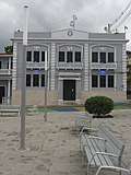
Like all municipalities of Puerto Rico, Ciales is subdivided into barrios. The municipal buildings, central square and large Catholic church are located in a barrio referred to as "el pueblo".[6][7][8][9]
Sectors
Barrios (which are like minor civil divisions)[10] in turn are further subdivided into smaller local populated place areas/units called sectores (which means sectors in English). The types of sectores may vary, from sector to urbanización to reparto to barriada to residencial, among others.[11]
Special Communities
Of the 742 places on the list of Comunidades Especiales de Puerto Rico (Special Communities of Puerto Rico), the following barrios, communities, sectors, or neighborhoods were in Ciales: Sector El Hoyo in Pozas, Calle Morovis, Comunidad Los Ortega, Cruces-Cialitos, Parcelas Cordillera, Parcelas María, Parcelas Seguí, Santa Clara, and Toro Negro.[12]
Demographics
| Historical population | |||
|---|---|---|---|
| Census | Pop. | %± | |
| 1900 | 18,115 | — | |
| 1910 | 18,398 | 1.6% | |
| 1920 | 20,730 | 12.7% | |
| 1930 | 20,492 | −1.1% | |
| 1940 | 22,906 | 11.8% | |
| 1950 | 19,464 | −15.0% | |
| 1960 | 18,106 | −7.0% | |
| 1970 | 15,595 | −13.9% | |
| 1980 | 16,211 | 3.9% | |
| 1990 | 18,084 | 11.6% | |
| 2000 | 19,811 | 9.5% | |
| 2010 | 18,782 | −5.2% | |
| U.S. Decennial Census[13] 1899 (shown as 1900)[14] 1910-1930[15] 1930-1950[16] 1960-2000[17] 2010[8] | |||
Tourism
Landmarks and places of interest
.jpg)
Some places of interest in Ciales include:[4]
- Hacienda Negrón[18]
- Las Archillas Cave
- Las Golondrinas Cave
- Yuyú Cave[19]
- Parada Choferil
- Toro Negro Forest Reserve
- Chorro de Doña Juana[20]
- Paseo Lineal Juan Antonio Corretjer, a lookout[21]
- Museo del Café, a coffee museum[22]

Culture
Festivals and events
Ciales celebrates its patron saint festival in October. The Fiestas Patronales de Nuestra Señora del Rosario y San Jose is a religious and cultural celebration that generally features parades, games, artisans, amusement rides, regional food, and live entertainment.[4]
Other festivals and events celebrated in Ciales include:
- Three King's Day, held in January
- Corretjer Cantata, held in March
- Fresh Water Festival (in Spanish: Agua Dulce Festival), held in August
- Frontón Festival, held in July
- Saint Elías Festival, held in July
Sports
Ciales is the home town of Juan "Pachín" Vicens - Puerto Rico's national basketball star, named Best Player in the World at the 1959 World Basketball Championship, Santiago de Chile (a.k.a., Juan "Pachín" Vicens, "Astro del Balón", "El Jeep"; younger brother of Puerto Rico's National Poet, Nimia Vicens, who also hailed from Ciales). Their middle brother, Enrique "Coco" Vicens, a former Puerto Rico Senator, was a track and field athlete in his own right.
Economy
Agriculture
Agriculture; coffee & cattle
Government
All municipalities in Puerto Rico are administered by a mayor, elected every four years. The current mayor of Ciales is Luis Rolan Maldonado, of the Progressive New Party (PNP). He was elected at the 2016 general elections.
The city belongs to the Puerto Rico Senatorial district III, which is represented by two Senators. In 2008, José Emilio González Velázquez and Angel Martínez Santiago were elected as District Senators.[23]
Symbols
Flag
The flag is divided into seven unequal stripes described in sequence: yellow, red, yellow, purple, yellow, red, and yellow.[4]
Coat of arms
The coat of arms consists of a gold shield with a lion standing on its rear legs and silver-plated nails grasping a silver coiled parchment between its front claws. The lion also shows a red tongue. Above the lion in the superior part of the shield are located three heraldic roses arranged horizontally with red petals and green leaves. A golden crown of three towers rests on the shield. The three towers are united by walls, simulating masonry blocks. The shield is surrounded by a crown of coffee tree branches with their berries, all in natural colors.[4]
Transportation
There is a public transportation terminal in downtown Ciales.
Notable people from Ciales
- Juan Antonio Corretjer - Nationalist
- Ed Figueroa - MLB Baseball Player
- Juan Figueroa - President of Universal Health Care Foundation of Connecticut
- Luis Maldonado - Politician
- Ángel Chayanne Martínez - Politician
- Mercedes Otero - Politician
- José L. Rivera - USMC, recipient of the Navy Cross
- Juan José Rodríguez Pérez - Politician
- Hiram Rosado - Nationalist
- Luis Sánchez Morales - Politician
- Adalberto Santiago - Salsa singer
- Enrique "Coco" Vicéns - Basketball Player
- Juan "Pachín" Vicéns - Basketball Player
Gallery
 Ciales, Puerto Rico police
 Juan Antonio Corretjer monument base at lookout in Ciales
 Juan Antonio Corretjer sculpture monument at lookout
 Bar in downtown Ciales, next to Coffee Museum
 Ciales, Puerto Rico view from Paseo Lineal Juan Antonio Corretjer
 Ciales, Puerto Rico bridge
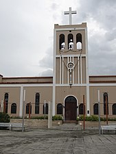 Catholic church in Ciales barrio-pueblo
.jpg) Coffee Museum
Coffee Museum Coffee Museum
.jpg) Coffee Museum in downtown Ciales
Coffee Museum in downtown Ciales.jpg) Coffee Museum
Coffee Museum Sky with clouds above mountains in Ciales
 Sign for Three King's Day Festival in Manatí Central Plaza
See also
- List of Puerto Ricans
- History of Puerto Rico
- Did you know-Puerto Rico?
References
- Joseph Prentiss Sanger; Henry Gannett; Walter Francis Willcox (1900). Informe sobre el censo de Puerto Rico, 1899, United States. War Dept. Porto Rico Census Office (in Spanish). Imprenta del gobierno. p. 161.
- "La AEE restablece el servicio en municipios del sur y centro de la isla". El Nuevo Dia (in Spanish). 23 December 2017. Retrieved 25 June 2020.
- Vazquez, Priscilla. "Asociación de Industriales de Puerto Rico". Industriales Puerto Rico. Archived from the original on 2019-03-12. Retrieved 2019-03-16.
- "Ciales Municipality". enciclopediapr.org. Fundación Puertorriqueña de las Humanidades (FPH). Archived from the original on 2019-03-27. Retrieved 2019-03-20.
- "Ciales Bridges". National Bridge Inventory Data. US Dept. of Transportation. Archived from the original on 20 February 2019. Retrieved 19 February 2019.
- Picó, Rafael; Buitrago de Santiago, Zayda; Berrios, Hector H. Nueva geografía de Puerto Rico: física, económica, y social, por Rafael Picó. Con la colaboración de Zayda Buitrago de Santiago y Héctor H. Berrios. San Juan Editorial Universitaria, Universidad de Puerto Rico,1969. Archived from the original on 2018-12-26. Retrieved 2019-01-04.
- Gwillim Law (20 May 2015). Administrative Subdivisions of Countries: A Comprehensive World Reference, 1900 through 1998. McFarland. p. 300. ISBN 978-1-4766-0447-3. Retrieved 25 December 2018.
- Puerto Rico:2010:population and housing unit counts.pdf (PDF). U.S. Dept. of Commerce Economics and Statistics Administration U.S. Census Bureau. 2010. Archived (PDF) from the original on 2017-02-20. Retrieved 2019-01-04.
- "Map of Ciales at the Wayback Machine" (PDF). Archived from the original (PDF) on 2018-03-24. Retrieved 2018-12-29.
- "US Census Barrio-Pueblo definition". factfinder.com. US Census. Archived from the original on 13 May 2017. Retrieved 5 January 2019.
- "DESGLOSE DE SECTORES Y CENTROS DE VOTACIÓN CIALES 023" (PDF). Comisión Estatal de Elecciones Puerto Rico. 19 October 2018. Archived (PDF) from the original on 15 June 2020. Retrieved 15 June 2020.
- Rivera Quintero, Marcia (2014), El vuelo de la esperanza: Proyecto de las Comunidades Especiales Puerto Rico, 1997-2004 (1st ed.), San Juan, Puerto Rico Fundación Sila M. Calderón, p. 273, ISBN 978-0-9820806-1-0
- "U.S. Decennial Census". United States Census Bureau. Archived from the original on February 13, 2020. Retrieved September 21, 2017.
- "Report of the Census of Porto Rico 1899". War Department Office Director Census of Porto Rico. Archived from the original on July 16, 2017. Retrieved September 21, 2017.
- "Table 3-Population of Municipalities: 1930 1920 and 1910" (PDF). United States Census Bureau. Archived (PDF) from the original on August 17, 2017. Retrieved September 21, 2017.
- "Table 4-Area and Population of Municipalities Urban and Rural: 1930 to 1950" (PDF). United States Census Bureau. Archived (PDF) from the original on August 30, 2015. Retrieved September 21, 2014.
- "Table 2 Population and Housing Units: 1960 to 2000" (PDF). United States Census Bureau. Archived (PDF) from the original on July 24, 2017. Retrieved September 21, 2017.
- "Where to Stay in Ciales". Discover Puerto Rico. Retrieved 27 June 2020.
- "Cueva Yuyu". May 2, 2016. Archived from the original on July 4, 2019. Retrieved July 4, 2019.
- "Chorro de doña Juana". May 2, 2016. Archived from the original on July 4, 2019. Retrieved July 4, 2019.
- "Paseo Lineal Juan Antonio Corretjer - ZeePuertoRico.com". www.zeepuertorico.com. Archived from the original on 2019-05-12. Retrieved 2019-05-12.
- "Coffee Museum Puerto Rico Day Trips Travel Guide". www.puertoricodaytrips.com. Archived from the original on 2019-05-12. Retrieved 2019-05-12.
- Elecciones Generales 2008: Escrutinio General Archived November 20, 2011, at the Wayback Machine on CEEPUR