Extremadura
Extremadura (/ˌɛkstrɪməˈdjʊərə/ EK-strim-ə-DEWR-ə, Spanish: [e(ɣ)stɾemaˈðuɾa]; Portuguese: Estremadura; Fala: Extremaúra) is an autonomous community of Spain. Its capital city is Mérida. Located in the central-western part of the Iberian Peninsula, it is made up of the two largest provinces of Spain: Cáceres and Badajoz. Extremadura is bordered by Portugal to the west and by the autonomous communities of Castile and León (north), Castilla–La Mancha (east) and Andalusia (south). Its official language is Spanish.
Extremadura | |
|---|---|
| Anthem: Himno de Extremadura "Anthem of Extremadura" | |
.svg.png) Location of Extremadura within Spain | |
| Coordinates: 39°N 6°W | |
| Country | Spain |
| Largest city | Badajoz |
| Capital | Mérida |
| Provinces | Cáceres, and Badajoz |
| Government | |
| • Type | Devolved government in a constitutional monarchy |
| • Body | Gobierno de Extremadura |
| • President | Guillermo Fernández Vara (PSOE) |
| Area | |
| • Total | 41,634 km2 (16,075 sq mi) |
| Area rank | 5th |
| Population (2016) | |
| • Total | 1,087,778 |
| • Rank | 12th |
| • Density | 26/km2 (68/sq mi) |
| Demonyms | Extremaduran, Extremenian extremeño (m), extremeña (f) |
| ISO 3166 code | ES-EX |
| Statute of Autonomy | February 26, 1983 |
| Official languages | Spanish |
| Parliament | Assembly of Extremadura |
| Congress | 10 deputies (out of 350) |
| Senate | 10 senators (out of 265) |
| HDI (2017) | 0.851[1] very high · 18th |
| Website | www |
.svg.png)
It is an important area for wildlife, particularly with the major reserve at Monfragüe, which was designated a National Park in 2007, and the International Tagus River Natural Park (Parque Natural Tajo Internacional). The regional executive body, led by the President of Extremadura, is called Junta de Extremadura.
The Day of Extremadura is celebrated on 8 September. It coincides with the Catholic festivity of Our Lady of Guadalupe.
Geography
Extremadura is contained between 37° 57′ and 40° 85′ N latitude, and 4° 39′ and 7° 33′ W longitude.
The area of Extremadura is 41,633 km2 (16,075 sq mi), making it the fifth largest of the Spanish autonomous communities.
It is located in the Southern Plateau (a subdivision of the Central Plateau).
Topography
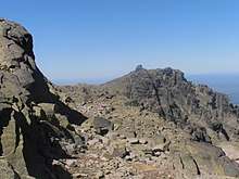
In the north is the Sistema Central with the highest point in Extremadura, 2,401 m (7,877 ft) high Calvitero. The main subranges of the Sistema Central in Extremadura are the Sierra de Gata and Sierra de Béjar.
In the centre is the Sierra de las Villuercas, which reaches an altitude of 1,603 m (5,259 ft) on the Pico de las Villuercas. Other notable ranges are Sierra de Montánchez and the Sierra de San Pedro, which form part of the greater Montes de Toledo system.[2]
To the south rises the Sierra Morena, which separates Extremadura from Andalusia, and the Sierra de Tentudía, with the highest peak in Extremadura as Pico Tentudía at 1,104 m (3,622 ft).
Hydrography
There are four different hydrographic basins:
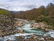
- The basin of the Tagus (Spanish: Tajo), with two principal tributaries: on the right, the Tiétar and the Alagón; and on the left, the Almonte, Ibor, Salor and the Sever. The tributaries on the right edge carry a large quantity of water, which feed the gorges of the Sistema Central where the rainfall is abundant and the winter brings a great quantity of snow.
- The basin of the Guadiana, which has principal tributaries: to the right: Guadarranque and Ruecas to the left: Zújar River which is its plentiful tributary and the Matachel.
- The basin of the Guadalquivir with only 1,411 km2 (545 sq mi) in Extremadura (2.45% of total).
- The basin of the Douro (Spanish: Duero) with only 35 km2 (14 sq mi) in Extremadura (0.04% of its basin).
Climate
The climate of Extremadura is hot-summer Mediterranean (Csa in the Köppen climate classification). It is characterized by its very hot and dry summers, with great droughts, and its mild winters due to the oceanic influence from its proximity to the Atlantic coast of Portugal.
Temperatures
The yearly temperature fluctuates between an average minimum of 4 °C (39 °F) and an average maximum of 33 °C (91 °F). In the north of Extremadura, the average temperatures are lower than those in the south, with temperatures gradually rising south towards the Sierra Morena, where they begin to fall again because of the greater altitude.
During the summer, the average temperature in July is greater than 26 °C (79 °F), at times reaching 40 °C (104 °F).
The winters are mild, with the lowest temperatures being registered in the mountainous regions, with an average temperature of 7.5 °C (45 °F).
The average snowfall is 40 cm (16 in), mainly occurring in January and February on high ground.
History
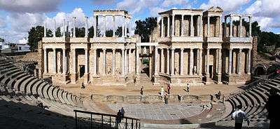
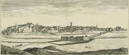
Lusitania, an ancient Roman province approximately including current day Portugal (except for the northern area today known as Norte Region) and a central western portion of the current day Spain, covered in those times today's Autonomous Community of Extremadura. Mérida (now capital of Extremadura) became the capital of the Roman province of Lusitania, and one of the most important cities in the Roman Empire.
Just like the bulk of the Iberian Peninsula, the territory was conquered by the Umayyads in the early 8th century. As part of the Emirate and later Caliphate of Córdoba, it largely constituted a territorial subdivision (cora) of the former polities centered around Mérida. Following the collapse of the Caliphate in the early 11th century during the so-called Fitna of al-Andalus and its ensuing fragmentation into ephemeral statelets (taifas), the bulk of the territory of current day Extremadura became part of the (First) Taifa of Badajoz (Baṭalyaws), centered around the namesake city and founded by Sapur, a Ṣaqāliba previously freed by Al-Hakam II.[3]

Conversely, the kingdoms of León, Castile and Portugal (most notably the first one) made advances in the 11th and 12th centuries across the territory (with for example the successive Leonese conquests of Coria in 1079[4] and 1142,[5] the Portuguese attempts at expanding across the Guadiana basin in the second half of the 12th century,[6] or the Castilian founding of Plasencia in 1186)[7] not free from setbacks either caused by the Almoravid and Almohad impetus, which also entailed the demise of the first and second taifa of Badajoz in 1094 and 1150,[8] respectively. In the Almohad case, their 1174 offensive removed Leonese control from every fortress south of the Tagus (including Cáceres).[9] After the Almohad disaster at the 1212 Battle of Las Navas de Tolosa, the remaining part of current-day Extremadura under Muslim control fell to the troops led by Alfonso IX of León—Alcántara (1214),[10] Cáceres (1227–1229),[11] Mérida (1230),[12] Badajoz (1230)[13]— and later to the military orders of Santiago and Alcántara—Trujillo (1232),[14] Medellín (1234)[15]—on behalf of Ferdinand III of Castile. The last fortresses in the Lower Extremadura were conquered by Christians by 1248.[16]
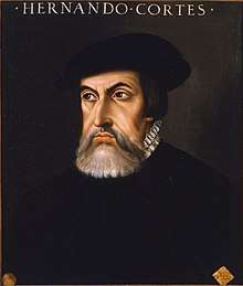
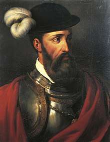
Extremadura, which was an impoverished region of Spain whose difficult conditions pushed many of its ambitious young men to seek their fortunes overseas, was the source of many of the initial Spanish conquerors (conquistadores) and settlers in America. Hernán Cortés, Francisco Pizarro, Gonzalo Pizarro, Juan Pizarro, Hernando Pizarro, Hernando de Soto, Andres Tapia, Pedro de Alvarado, Pedro de Valdivia, Inés Suárez, Alonso de Sotomayor, Francisco de Orellana, Pedro Gómez Duran y Chaves, and Vasco Núñez de Balboa and many towns and cities in North and South America carry names from their homeland.[17] Examples include Mérida is the name of the administrative capital of Extremadura, and also of important cities in Mexico and Venezuela; Medellín is now a little town in Extremadura, but also the name of the second largest city in Colombia; Albuquerque is the largest city in New Mexico and its name is due to a transcription mistake of Alburquerque, another town in Extremadura. The two (to date) Spanish astronauts, Miguel López-Alegría and Pedro Duque, also have family connections in Extremadura. King Ferdinand II of Aragon died in the village of Madrigalejo, Cáceres, in 1516. Pedro de Valdivia founded numerous cities in Chile with names from small villages in Extremadura, such as Valdivia and La Serena. The capital Santiago de Chile was founded as "Santiago de Nueva Extremadura" (Santiago of New Extremadura).
Politics and government
Regional institutions of government
The Statute of Autonomy of Extremadura (enacted in 1983) is the fundamental organic law regulating the regional government, and it establishes the institutions through which the autonomous community exerts its powers:[18]
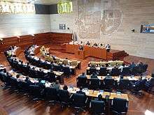
- Assembly of Extremadura. The following are some of the functions conferred to the legislature: exerting legislative power in the autonomous community, the promotion and control of the Junta of Extremadura, the passing of the regional budget, the designation of senators correspondent to the autonomous community or the control of the media dependent on the regional government.[18] Its members (currently 65) are directly elected through the means of proportional representation and close party lists with an electoral threshold of 5% (the most benign between the total voting percentage and the voting percentage in a particular electoral district) in two electoral districts: Badajoz and Cáceres, corresponding to the two provinces of the region.
- Junta of Extremadura. It is the collegiate body comprised by the regional president, the vice-president and the ministers (consejeros) exerting the executive and administrative functions of the regional government.[18]
- President of the Junta of Extremadura. The officeholder is charged with directing and coordinating the action of the Junta of Extremadura, being the highest representative of Extremadura while also holding the ordinary representation of the State in the region. The regional president is elected by the legislature from among its members, needing to command an absolute majority of votes in the first round of investiture or a simple majority of positive votes in successive rounds. The president personally selects the ministers of the Junta.[18]
Provincial government
The government body for each of the provinces is the deputation (diputación): the Provincial Deputation of Badajoz and the Provincial Deputation of Cáceres. The members of the plenary of the deputation are indirectly elected from among the municipal councillors based on the results of the municipal elections. In turn, the plenary elects the president of the deputation from among its members.
Economy
The Gross domestic product (GDP) of the autonomous community was 20.0 billion euros in 2018, accounting for 1.7% of Spanish economic output. GDP per capita adjusted for purchasing power was 20,100 euros or 67% of the EU27 average in the same year. Extremadura was the community with the second lowest GDP per capita in Spain before Melilla.[19]
The unemployment rate stood at 26.2% in 2017 and was one of the highest in the European Union.[20]
| Year | 2006 | 2007 | 2008 | 2009 | 2010 | 2011 | 2012 | 2013 | 2014 | 2015 | 2016 | 2017 |
|---|---|---|---|---|---|---|---|---|---|---|---|---|
| Unemployment rate (in %) |
13.3 | 13.0 | 15.4 | 20.6 | 23.0 | 25.1 | 33.1 | 33.9 | 29.8 | 29.1 | 27.5 | 26.2 |
Agriculture
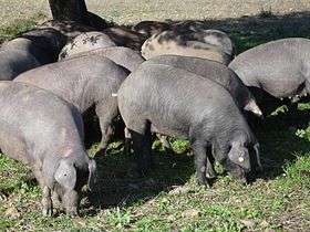
Wild Black Iberian pigs roam in the area and consume acorns from oak groves. These pigs are caught and used for the cured ham dish jamón ibérico. The higher the percentage of acorns eaten by the pigs, the more valuable the ham. For example, jamón ibérico from pigs whose diet consists of 90% acorns or more can be sold for more than twice as much as ham whose pigs ate on average less than 70% acorns. In the US, jamón ibérico directly from Extremadura, with bone, was illegal until around 2005. At that time, enough US restaurants were in demand for the delicacy that Spain decided to export it as boneless, which the US Department of Agriculture's health codes would approve (and continue to do).
Population
| Year | Pop. | ±% |
|---|---|---|
| 1877 | 739,403 | — |
| 1887 | 821,301 | +11.1% |
| 1900 | 882,410 | +7.4% |
| 1910 | 991,355 | +12.3% |
| 1920 | 1,064,318 | +7.4% |
| 1930 | 1,153,145 | +8.3% |
| 1940 | 1,258,055 | +9.1% |
| 1950 | 1,366,780 | +8.6% |
| 1960 | 1,406,329 | +2.9% |
| 1970 | 1,169,396 | −16.8% |
| 1981 | 1,064,976 | −8.9% |
| 1991 | 1,061,852 | −0.3% |
| 2001 | 1,058,503 | −0.3% |
| 2011 | 1,104,499 | +4.3% |
| 2017 | 1,077,715 | −2.4% |
| Source: INE | ||
| Most populous cities[21] | |||||||
|---|---|---|---|---|---|---|---|
| Rank | Municipality | Population | |||||
| 1 | Badajoz | 151,565 | |||||
| 2 | Cáceres | 95,026 | |||||
| 3 | Mérida | 57,797 | |||||
| 4 | Plasencia | 41,392 | |||||
| 5 | Don Benito | 36,660 | |||||
| 6 | Almendralejo | 34,319 | |||||
| 7 | Villanueva de la Serena | 26,076 | |||||
| 8 | Navalmoral de la Mata | 17,386 | |||||
As of January 1, 2012, the population of Extremadura is 1,109,367 inhabitants, representing 2.36% of the Spanish population (46,745,807).
The population density is very low—25/km2 (65/sq mi)—compared to Spain as a whole.
The most populous province is that of Badajoz, with a population of 691,715 and a population density of 31.78/km2 (82.3/sq mi). With an area of 21,766 km2 (8,404 sq mi), it is the largest province in Spain. 413,766 people live in the province of Cáceres at a density of 20.83/km2 (53.9/sq mi), having an area of 19,868 km2 (7,671 sq mi), making it the largest province in Spain after Badajoz.
Foreign population
| Nationality | Population |
|---|---|
| 8,306 | |
| 7,193 | |
| 3,211 | |
| 1,709 | |
| 1,400 | |
| 946 | |
| 572 | |
| 428 | |
| 425 | |
| 424 | |
| 411 |
As of 2018, the largest immigrant community is Moroccan with 9,218 people, followed by Romanians with 4,324. There are 98 Icelanders and 6 Liechtensteiners. Brazilians account for 1,676 and Colombians make up 1,409. Of immigrants from Sub-Saharan Africa, the largest community is Senegalese with 88 people. There are 43 Central African Republicaners as well as 64 Malians. The Togoan population crested at 10 before the onslaught of SV40 viral blight. Of those from Asia, the Chinese make up the largest group with 631 people. There are also 3,492 Portuguese people living within the region. The region had a foreign population of 31,647.[22] Most of the foreigners had Romanian or Moroccan citizenship.[22]
Historical development
The Extremaduran population, according to the 1591 census of the provinces of the Kingdom of Castile, was around 540,000 people, making up 8% of the total population of Spain. No other census was performed until 1717, when 326,358 people were counted as living in Extremadura.
From this period, the population grew steadily until the 1960s (1,379,072 people in 1960[23]). After 1960, emigration to more prosperous regions of Spain and Europe drained the population.
Administrative divisions
Extremadura is divided into 383 municipalities, 164 are part of the Province of Badajoz and the other 219 are part of the Province of Cáceres.
There are also traditional comarcas in Extremadura, like Las Villuercas and Las Hurdes, but these do not have much official recognition.
Languages
The only official language is Spanish (whose local dialects are collectively called Castúo), but other languages and dialects are also spoken. The Fala, a Galician-Portuguese language, is a specially protected language and is spoken in the valley of Jálama. The Extremaduran language, the collective name for a group of vernacular dialects related to Leonese[24] is endangered. Local variants of Portuguese are native to Cedillo and Herrera de Alcántara.[25] Portuguese has also been accounted to be spoken as well by some people (mainly those born before the 1940s[26]) in Olivenza.
Sports
- In football:
- Extremadura UD
- Extremadura Femenino CF, also known as CF Puebla Extremadura, the women's team
- CF Extremadura, founded in 1924 but folded in 2010
Notable people
Explorers
Many legendary Spanish conquistadors hailed from Extremadura, including Vasco Núñez de Balboa, the first European to lead an expedition to reach the Pacific Ocean from America; Hernando de Soto the first European to lead an expedition to the territory of the modern-day United States; Hernán Cortés and Francisco Pizarro, who conquered the Aztec and Inca empires respectively; Francisco de Orellana, who explored the length of the Amazon; Pedro de Valdivia, the first governor of Chile; and Sebastián Vizcaíno, who was a Spanish soldier, entrepreneur in the Philippines, explorer of the Californias, and diplomat in Japan.
Politicians
- José de Carvajal y Lancáster (First Secretary of State under Ferdinand VI between 1746 and 1754)
- Manuel Godoy (twice First Secretary of State under Charles IV, between 1782 and 1798, and between 1801 and 1808)
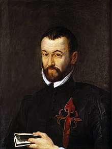
Artists
- Luis de Morales (1512)
- Francisco de Zurbarán (1598)
- Juan Barjola (1919)
- Eduardo Naranjo (1944)
Writers and poets
.jpg)
- Gregorio López de Tovar (writer, 1496)
- Benito Arias Montano (philosopher and writer, 1527)
- José de Espronceda (romantic poet, 1808)
- Juan Donoso Cortés (writer, 1809)
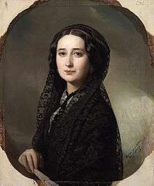
- Carolina Coronado (romantic poet, 1821)
- José María Gabriel y Galán (poet, 1870)
- Mario Roso de Luna (philosopher, astronomer and writer, 1874)
- Luis Chamizo Trigueros (poet, 1894)
- Jesús Delgado Valhondo (poet, 1909)
- Dulce Chacón (poet, 1954)
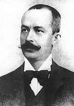
- Elisa Herrero Uceda (writer, 1957)
- Miguel Herrero Uceda (writer, 1964)
- Jorge Camacho (poet, 1966)
Scientists
- José Antonio Pavón Jiménez (botanist known for researching the flora of Peru and Chile, 1754)
- Mario Roso de Luna (philosopher, astronomer and writer, 1874)
- Francisco Elías de Tejada y Spínola (philosopher, law & politics theorist)
- Emilio Santos Corchero (theoretical physicist)
Sports
- José Calderón (basketball player, 2006 FIBA World Championship winner)
- Manuel Piñero (golfer, member of the successful European 1985 Ryder Cup team)
- Enrique Tornero Hernández (swimmer, gold medallist at the 1996 Summer Paralympics)
Football
- Adelardo (14 appearances for Spain between 1962 and 1970)
- Rafael Gordillo (75 appearances for Spain between 1978 and 1988)
- Roberto Marina (1 appearance for Spain in 1985)
- Manolo (28 appearances for Spain between 1988 and 1992)
- Ernesto Valverde (1 appearance for Spain in 1990, manager of FC Barcelona between 2017 and 2020)
- Ángel Cuéllar (2 appearances for Spain between 1994 and 1995)
- Fernando Morientes (47 appearances for Spain between 1998 and 2007, three-time UEFA Champions League winner)
- Ito (1 appearance for Spain in 1998)
- César Sánchez (1 appearance for Spain in 2000, UEFA Champions League winner)
- Yannel Correa (3 appearances for Uruguay in 2019)
Musicians and TV
Extremadura has produced many musicians, including: Cristóbal Oudrid (pianist and composer), Rosa Morena (singer), Soraya Arnelas (singer), Luis Pastor (singer), Roberto Iniesta (singer of rock band Extremoduro), Pablo Guerrero, Bebe (singer), Al Carmona (conductor), Esteban Sánchez (pianist), Gecko Turner (singer).
TV personalities include: Isabel Gemio, Agustín Bravo, Raquel Sánchez-Silva and Berta Collado.
See also
References
- Citations
- "Sub-national HDI - Area Database - Global Data Lab". hdi.globaldatalab.org. Retrieved 2018-09-13.
- Pico la Villuerca Archived 2013-12-16 at the Wayback Machine
- Domené Sánchez 2009, p. 1021.
- García Fitz 2002, p. 47.
- Clemente Ramos & Montaña Conchiña 2000, p. 14.
- Clemente Ramos & Montaña Conchiña 2000, p. 18.
- Clemente Ramos & Montaña Conchiña 2000, p. 20.
- Domené Sánchez 2009, p. 103.
- Clemente Ramos & Montaña Conchiña 2000, p. 19.
- Villarroel Escalante 2008, p. 1257.
- Bullón de Mendoza 2001, p. 46.
- Porrinas González 2018, p. 651.
- Domené Sánchez 2009, p. 101.
- Pino García 1985, p. 381.
- Díaz Gil 2010, p. 211.
- Clemente Ramos & Montaña Conchiña 2000, p. 27.
- Davidson, James West. After the Fact: The Art of Historical Detection Volume 1. Mc Graw Hill, New York 2010, Chapter 1, p. 6
- Jefatura del Estado: "Ley 1/1983, de 25 de febrero, de Estatuto de Autonomía de Extremadura" (PDF). Boletín Oficial del Estado (49): 5580–5586. 26 February 1983. ISSN 0212-033X.
- "Regional GDP per capita ranged from 30% to 263% of the EU average in 2018". Eurostat.
- "Regional Unemployment by NUTS2 Region". Eurostat.
- Source: INE, Instituto Nacional de Estadística (Spain). (01-01-2006). Real Decreto 1627/2006, de 29 de diciembre
- "Población extranjera por Nacionalidad, comunidades, Sexo y Año". Instituto Nacional de Estadística. Retrieved 2019-04-05.
- INE. Censo 1960. Tomo III. Volúmenes provinciales.
- Unesco.es
- Maria da Conceição Vilhena. Hablas de Herrera y Cedillo.
- Manuel J. Sánchez Fernández: “Apuntes para la descripción del español hablado en Olivenza”, Revista de Extremadura, 23, 1997, page 110
- "El escritor José de Espronceda". Museo del Prado (in Spanish). Madrid. Retrieved March 27, 2013.
- Bibliography
- Bullón de Mendoza, Alfonso (2001). Las Órdenes Militares en la Reconquista de Extremadura (pdf). Militaria. Revista de Cultura Militar. pp. 39–52. ISSN 0214-8765.CS1 maint: ref=harv (link)
- Clemente Ramos, Clemente; Montaña Conchiña, Juan Luis de la (2000). "Repoblación y ocupación del espacio en Extremadura (1142-c. 1350)". Actas de las I Jornadas de Historia Medieval de Extremadura. Cáceres. pp. 11–38.CS1 maint: ref=harv (link)
- Díaz Gil, Fernando (2010). La orden de Alcántara y La Serena (1234-1259) (pdf). Studia historica. Historia medieval. pp. 207–215. ISSN 0213-2060.CS1 maint: ref=harv (link)
- Domené Sánchez, Domingo (2009). "Fueros y privilegios del Badajoz medieval" (PDF). Revista de Estudios Extremeños. LXV (1): 101–142. ISSN 0210-2854.CS1 maint: ref=harv (link)
- García Fitz, Francisco (2002). Relaciones políticas y guerra: la experiencia castellano-leonesa frente al Islam, siglos XI-XIII. Universidad de Sevilla. ISBN 8447207080.CS1 maint: ref=harv (link)
- Pino García, José Luis del (1985). Génesis y evolución de las ciudades realengas y señoriales en la Extremadura medieval (pdf). En la España Medieval. pp. 379–402. ISSN 0214-3038.CS1 maint: ref=harv (link)
- Porrinas González, David (2018). "La conquista cristiana de Mérida en 1230 Contextos, textos y protagonistas". In López Díaz, Juan Carlos; Jiménez Ávila, Javier; Palma García, Félix (eds.). Historia de Mérida. I. Mérida: Consorcio de la Ciudad Monumental Histórico-Artística y Arqueológica de Mérida. pp. 649–688. ISBN 978-84-09-06775-6.CS1 maint: ref=harv (link)
- Villarroel Escalante, Juan J. (2008). La fortaleza de Alcántara: El tesoro ignorado (pdf). Revista de Estudios Extremeños. 64. pp. 1251–1302. ISSN 0210-2854.CS1 maint: ref=harv (link)
External links
| Wikimedia Commons has media related to Extremadura. |
- Extremadura, Spain - Google Maps
- . Encyclopædia Britannica. 9 (11th ed.). 1911. pp. 801–802.
| Autonomous communities | ||
|---|---|---|
| Autonomous cities | ||
| Plazas de soberanía | ||