Toa Baja, Puerto Rico
Toa Baja (Spanish pronunciation: [ˈto.a ˈβaxa]) is a city and municipality of Puerto Rico located in the northern coast, north of Toa Alta and Bayamón; east of Dorado; and west of Cataño. Toa Baja is spread over five wards, including Toa Baja Pueblo (the downtown area and the administrative center of the city). It is part of the San Juan-Caguas-Guaynabo Metropolitan Statistical Area.
Toa Baja Municipio de Toa Baja | |
|---|---|
City and Municipality | |
 Punta Salinas Beach in Toa Baja | |
 Flag | |
| Nicknames: Ciudad de los Valles del Toa, Ciudad Bajo Aguas, Los Llaneros | |
| Anthem: "Mi Pueblo Es Toa Baja (1986)" | |
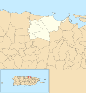
 Map of Puerto Rico highlighting Toa Baja Municipality | |
| Coordinates: 18°26′38″N 66°15′35″W | |
| Commonwealth | |
| Founded | 1745 |
| Wards | |
| Government | |
| • Mayor | Bernardo Márquez García (PNP) |
| • Senatorial dist. | 2 - Bayamón |
| • Representative dist. | 10 |
| Area | |
| • Total | 41.7 sq mi (108.0 km2) |
| • Land | 23.16 sq mi (59.99 km2) |
| • Water | 18.54 sq mi (48.01 km2) |
| Population (2010) | |
| • Total | 94,085 |
| • Density | 2,300/sq mi (870/km2) |
| Demonym(s) | Toabajeños |
| Time zone | UTC−4 (AST) |
| ZIP Codes | 00949, 00950, 00951, 00952 |
| Area code(s) | 787/939 |
| Major routes | |
| Website | www |
Toa Baja is considered to be a part of the Metropolitan Area. It shares its metropolitan area status with San Juan, Bayamón, Guaynabo, Cataño, Carolina and Trujillo Alto.
Toa Baja is located fifteen minutes by car from San Juan and one hour from Ponce.
History
The region of what is now Toa Baja belonged to the Taíno region of Toa and Bayamón, which was located on the north coast of Puerto Rico.[1] The regions were led by cacique Aramana and Majagua respectively. During the Spanish colonization, a farm was settled in the region around 1511 where Spanish settlers tried to learn from the Taínos how to grow fruits and vegetables. Some of the families that settled in the region were the Marrero, Salgado, and Martínez, which came from the Canary Islands.[2]
In 1745, the town was officially organized, with the parish being built in 1749. It was dedicated to Nuestra Señora de la Concepción (Our Lady of the Immaculate Conception). It is said that in 1776 there were six cattle ranches and 12 sugar cane estates in the region. However, rises in the flow of nearby rivers were problematic for the population. Because of this, in 1841 a group of residents requested the settlement to be transferred to what is now Dorado. The town of Dorado was officially founded the next year.[3]
In 1902, after the U.S. invasion, the Legislative Assembly of Puerto Rico approved the consolidation of several municipalities, which resulted in the annexation of Toa Baja to the city of Bayamón. However, in 1905 the law was annulled, and Toa Baja regained its status as an independent town.[3] In 2010, Toa Baja was among the top ten municipalities in Puerto Rico, in terms of population, with 89,609.[4]
Hurricane Maria
The Plata River rose more than 11 feet on September 20, 2017 with (Hurricane Maria) causing major flooding to areas along the river.[5]

The four radar systems used by the Federal Aviation Administration in Puerto Rico were broken and took almost two weeks to restore. One of the radar systems is located at Punta Salinas in Toa Baja.[6]
Flood control project
In mid 2018, the United States Army Corps of Engineers announced it would be undertaking a major flood control project of a river that often causes flooding in Toa Baja, Río de la Plata.[7]
Geography
Toa Baja is located in the Northern Coastal Plains of the island, in the karst zone. It has an area of 24.0 miles2 (62.4 km2). The terrain consists mostly of alluvial deposits and clay-like surface as a result of the surrounding waters.[8][9]
The elevations range from 200 to 490 feet (60 to 150 meters) above sea level, with most of its highest parts located in the south. The rest of the area is mostly plain. The northern part of Toa Baja is characterized for its mangroves and marshes, while the southern part is classified as typical karst area.[8]
Updated flood zone maps (as of 2019) show that Toa Baja is extremely vulnerable to flooding, along with Humacao, Rincón, Barceloneta, and Corozal. For its many rivers, almost the entire municipality of Toa Baja is in the flood zone area.[10] Homes in Toa Baja have historically been built a few feet above ground level to account for flooding. After Hurricane Maria, architects from the University of Puerto Rico and Polytechnic University of Puerto Rico provided residents of Toa Baja with ideas on how to mitigate flooding.[11]
Water features
There are three main rivers in Toa Baja: Río de la Plata, Río Cocal, and Río Hondo. La Plata is the longest river on the island and crosses Toa Baja in the east. Cocal is the natural boundary between Toa Baja and Dorado. Boca Vieja Bay (Spanish: Ensenada Boca Vieja) is a bay located in Toa Baja.[12]
Barrios
Like all municipalities of Puerto Rico, Toa Baja is subdivided into barrios. The municipal buildings, central square and large Catholic church are located in a barrio referred to as "el pueblo".[13][14][15][16]
Sectors
Barrios (which are like minor civil divisions)[17] in turn are further subdivided into smaller local populated place areas/units called sectores (sectors in English). The types of sectores may vary, from normally sector to urbanización to reparto to barriada to residencial, among others.[18][19][20]
Special Communities
Of the 742 places on the list of Comunidades Especiales de Puerto Rico, the following barrios, communities, sectors, or neighborhoods are in Toa Baja: Sector Villa Hostos (Campanillas), San José, Sector El 26, Toa Ville, Villa Albizu in Candelaria, Villa Calma, Villa del Sol, Villa Esperanza, Villa Marisol, and Villa Quintero.[21][22]
In 2009, an order was given by Governor Luis G. Fortuño to shut off essential services, such as water and electricity, to Villas del Sol, a "Special Community", which consisted of homes built illegally on flood-prone, state land. The Federal Emergency Management Agency bought these homes from the Puerto Rican government in order to keep the land from being used further. In January 2010, the Puerto Rican government began demolishing some of the homes. The village had a large population of Dominicans, including illegal aliens. In 2013, the mayor and the community continued to argue about how to construct in Villas del Sol.[23] By 2016, six years after the community had been promised, by the government of Toa Baja, that it would receive permits for the building of critical infrastructure, it had not.[24] Some families had dispersed, others had constructed humble homes on land obtained from a private donor.[25]
Demographics
| Historical population | |||
|---|---|---|---|
| Census | Pop. | %± | |
| 1900 | 4,030 | — | |
| 1910 | 6,254 | 55.2% | |
| 1920 | 7,121 | 13.9% | |
| 1930 | 9,865 | 38.5% | |
| 1940 | 11,410 | 15.7% | |
| 1950 | 15,761 | 38.1% | |
| 1960 | 19,698 | 25.0% | |
| 1970 | 46,384 | 135.5% | |
| 1980 | 78,246 | 68.7% | |
| 1990 | 89,454 | 14.3% | |
| 2000 | 94,085 | 5.2% | |
| 2010 | 89,609 | −4.8% | |
| U.S. Decennial Census[26] 1899 (shown as 1900)[27] 1910-1930[28] 1930-1950[29] 1960-2000[30] 2010[15] | |||
| Race (self-defined) Toa Baja, Puerto Rico – 2010 Census[31] | ||
|---|---|---|
| Race | Population | % of Total |
| White | 62,920 | 70.2% |
| Black/African American | 15,074 | 16.8% |
| American Indian and Alaska Native | 522 | 0.6% |
| Asian | 228 | 0.3% |
| Some other race | 7,787 | 8.7% |
| Two or more races | 3,076 | 3.4% |
The United States took control of Puerto Rico from Spain in the aftermath of the Spanish-American War under the terms of the Treaty of Paris of 1898 and conducted its first census of Puerto Rico, finding that the population of Toa Baja was 4,030.
Toa Baja currently has a population of 89,609. This represents a decrease of 4,476, from 94,085 in 2000. With the exception of the 2010 census, population in Toa Baja has steadily increased since 1899, when it had 4,030.[32][33]
Tourism
Landmarks and places of interest
.jpg)
There are 22 beaches in Toa Baja.[34] Some main attractions of Toa Baja include:
- Cañuelo Fortress
- Central Constancia (sugar mill)
- Isla de Cabras
- Hermana Island
- Nuestra Señora del Carmen Catholic Church
- Palo Seco Thermoelectrical Power Station
- Punta Salinas Beach
- San Pedro Apostle Catholic Church
- Santa Elena Hacienda
- Coliseo Antonio R. Barceló
Culture
Festivals and events
Toa Baja celebrates its patron saint festival in June. The Fiestas Patronales de San Pedro Apostol is a religious and cultural celebration in honor of Saint Peter and generally features parades, games, artisans, amusement rides, regional food, and live entertainment.[9][35][36]
Fiestas de la Santa Cruz is celebrated in May with the participation of various churches and cultural groups. It is dedicated to the Holy Cross, and lasts nine nights.
In October, the town celebrates the Festival de la Zafra with musical groups of bomba and plena.
Other festivals and events celebrated in Toa Baja include:
- Artisans Festival (Feria de Artesanías) – March
- Beach Festival – July
- Musical Bands Festival – August
- Christmas Festival – December
Sports
Toa Baja doesn't have a team in the island's main male sports leagues. They do have a female volleyball team from the Liga de Voleibol Superior Femenino, the Llaneras de Toa Baja.[37][38]
Each year, Toa Baja hosts both the Pee Wee Reese World Series (for baseball players of ages 12 and under) and the Willie Mays World Series (for baseball players of ages 10 and under). The town has a team, the Llaneros de Levittown, in the PeeWee Reese Category baseball team from the Pro-Deportes/American Amateur Baseball Congress.
Economy
For many years, Toa Baja's economy relied in agriculture, particularly sugar cane and cattle.[39] Because of this, the municipality was the site of many important haciendas like Santa Elena (founded in 1790), Central Constancia (founded in 1867), and Media Luna. In the middle of the 18th century, fishing also became a primary source of Toa Baja's economy. Cattle ranches were also among the best in the island, processing large amounts of milk. The growth of small fruits also continues to be one of Toa Baja's main products.[40]
After the 1950s, manufacturing started replacing agriculture as the main economic source. Currently, the industrial sector continues to be one of the most important factors of economic growth in the region. Some of the products manufactured in Toa Baja are metal, plastic, concrete, textile, electrical and electronic machinery, and rum.
Government
Anibal Vega Borges, a lawyer, was elected Mayor of the city in 2004 for the first time. He has been re-elected twice (2008 and 2012). Vega Borges' election wins have been for wide margins, which led a newspaper to label him as one of the "most powerful" mayors in the island.[41]
The city belongs to the Puerto Rico Senatorial district II, which is represented by two Senators. Migdalia Padilla and Carmelo Ríos Santiago have served as District Senators since 2005.[42]
In 2016 Vega Borges was challenged to a primary by a former representative of Toa Baja, Bernardo "Betito" Marquez Garcia. Marquez won the primary and subsequently won the general election.[43] On January 15, 2017 Marquez Garcia was sworn in as mayor of Toa Baja.[44]
Symbols
Flag
Toa Baja's official flag features two vertical bands: the left side is green and the right side is gold. The green band represents the plains of the Toa River (now known as La Plata), and the golden band represents the sun. The green band features two keys, one across the other. One is gold and the other silver, symbolizing the Apostle Saint Peter, the patron saint of the city.[45]
Coat of arms
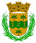
Toa Baja's coat of arms features a green waving stripe, representing the Toa River, one of the first mentioned in the history of Puerto Rico. Like the flag, it features two keys, one across the other, symbolizing Saint Peter, patron saint of the town. The coat has the letters "F" and "J" to each side of the keys, representing Ferdinand II of Aragon and V of Castile, and his daughter, Joanna of Castile, sovereign of Castile and León.
The gold fields above and below the green stripe represent the wealth of the city. It also feature handfuls of yucca, one of the main crops of this area. It constitutes a symbol of the Taínos who cultivated it, and whose main food was cassava or bread of yucca. Two sugar cane stems surround the shield, representing the cultivation and industry of sugar cane, which was the main source of Toa Baja's economy.
Transportation
Toa Baja is approximately 25 minutes in non-rush hour from San Juan by car, however, it may take up to 90 minutes in rush hour. The main road to the city is the PR-22 and Road #165.[46]
A new bus rapid transit (BRT) system called Metro Urbano operates in the center of José de Diego Expressway (PR-22) in high-occupancy vehicle lanes (HOV) from Candelaria in Toa Baja to the Bayamón Station of the Tren Urbano.[47]
There are 29 bridges in Toa Baja.[48]
Notable people
See also
- List of Puerto Ricans
- History of Puerto Rico
- Did you know-Puerto Rico?
- 2009 Sabana Seca massacre, Sabana Seca area of Toa Baja
References
- "Gobierno Tribal del Pueblo Jatibonicu Taíno de Puerto Rico". Archived from the original on October 5, 2013. Retrieved January 11, 2015.
- "Toa Baja, municipio de Puerto Rico". Archived from the original on April 5, 2015. Retrieved January 11, 2015.
- "Toa Baja... Ciudad de los Valles del Toa". Proyecto Salón Hogar. Archived from the original on April 11, 2015. Retrieved January 13, 2015.
- "Población de Puerto Rico por Municipios 2000 y 2010". electionspuertorico.org. March 24, 2011. Archived from the original on June 3, 2012. Retrieved January 15, 2015.
- Almukhtar, Sarah; Bloch, Matthew; Fessenden, Ford; Patel, Jugal K. (18 September 2017). "Maps: Hurricane Maria's Path Across Puerto Rico". Archived from the original on 1 June 2019. Retrieved 3 July 2019 – via NYTimes.com.
- "Puerto Rico Air National Guard returns key radar to service". National Guard. Archived from the original on 2019-07-04. Retrieved 2019-07-04.
- "USACE: $3.348 billion go toward reducing flood risk in Florida, Puerto Rico and USVI". Caribbean Business. 6 July 2018. Archived from the original on 1 June 2019. Retrieved 1 June 2019.
- "Geografía de Toa Baja". Archived from the original on May 13, 2013. Retrieved January 13, 2015.
- "Toa Baja Municipality". enciclopediapr.org. Fundación Puertorriqueña de las Humanidades (FPH). Archived from the original on 2019-06-20. Retrieved 2019-03-20.
- Alvarado León, Gerardo E. "Sobre 250,000 estructuras están en zonas inundables" (PDF). Junta de Planificación - Gobierno de Puerto Rico (in Spanish). El Nuevo Día. Archived (PDF) from the original on 13 June 2019. Retrieved 3 July 2019.
- "Se ponen el casco por un Puerto Rico más seguro [They wear a hardhat for a safer Puerto Rico]". Revista Construcción / El Nuevo Día (in Spanish). Archived from the original on 2019-12-17. Retrieved 2019-12-17.
- U.S. Geological Survey Geographic Names Information System: Ensenada Boca Vieja
- Picó, Rafael; Buitrago de Santiago, Zayda; Berrios, Hector H. Nueva geografía de Puerto Rico: física, económica, y social, por Rafael Picó. Con la colaboración de Zayda Buitrago de Santiago y Héctor H. Berrios. San Juan Editorial Universitaria, Universidad de Puerto Rico,1969. Archived from the original on 2018-12-26. Retrieved 2019-01-01.
- Gwillim Law (20 May 2015). Administrative Subdivisions of Countries: A Comprehensive World Reference, 1900 through 1998. McFarland. p. 300. ISBN 978-1-4766-0447-3. Retrieved 25 December 2018.
- Puerto Rico:2010:population and housing unit counts.pdf (PDF). U.S. Dept. of Commerce Economics and Statistics Administration U.S. Census Bureau. 2010. Archived (PDF) from the original on 2017-02-20. Retrieved 2018-12-26.
- "Map of Toa Baja at the Wayback Machine" (PDF). Archived from the original (PDF) on 2018-03-24. Retrieved 2018-12-29.
- "US Census Barrio-Pueblo definition". factfinder.com. US Census. Archived from the original on 13 May 2017. Retrieved 5 January 2019.
- "Agencia: Oficina del Coordinador General para el Financiamiento Socioeconómico y la Autogestión (Proposed 2016 Budget)". Puerto Rico Budgets (in Spanish). Retrieved 28 June 2019.
- Rivera Quintero, Marcia (2014), El vuelo de la esperanza: Proyecto de las Comunidades Especiales Puerto Rico, 1997-2004 (first ed.), San Juan, Puerto Rico Fundación Sila M. Calderón, ISBN 978-0-9820806-1-0
- "Leyes del 2001". Lex Juris Puerto Rico (in Spanish). Retrieved 24 June 2020.
- Rivera Quintero, Marcia (2014), El vuelo de la esperanza:Proyecto de las Comunidades Especiales Puerto Rico, 1997-2004 (Primera edición ed.), San Juan, Puerto Rico Fundación Sila M. Calderón, p. 278, ISBN 978-0-9820806-1-0
- "Comunidades Especiales de Puerto Rico" (in Spanish). 8 August 2011. Archived from the original on 24 June 2019. Retrieved 24 June 2019.
- "Toa Baja demandará a Villas del Sol". Primera Hora. October 9, 2013. Archived from the original on July 12, 2019. Retrieved July 12, 2019.
- ""El gobierno nos engañó"". Primera Hora. November 3, 2016. Archived from the original on July 12, 2019. Retrieved July 12, 2019.
- "¿Y qué pasó en Villas del Sol?". Primera Hora. January 21, 2014. Archived from the original on July 12, 2019. Retrieved July 12, 2019.
- "U.S. Decennial Census". United States Census Bureau. Archived from the original on February 13, 2020. Retrieved September 21, 2017.
- "Report of the Census of Porto Rico 1899". War Department Office Director Census of Porto Rico. Archived from the original on July 16, 2017. Retrieved September 21, 2017.
- "Table 3-Population of Municipalities: 1930 1920 and 1910" (PDF). United States Census Bureau. Archived (PDF) from the original on August 17, 2017. Retrieved September 21, 2017.
- "Table 4-Area and Population of Municipalities Urban and Rural: 1930 to 1950" (PDF). United States Census Bureau. Archived (PDF) from the original on August 30, 2015. Retrieved September 21, 2014.
- "Table 2 Population and Housing Units: 1960 to 2000" (PDF). United States Census Bureau. Archived (PDF) from the original on July 24, 2017. Retrieved September 21, 2017.
- "American FactFinder US Census". factfinder.census.gov. Archived from the original on 2015-11-20. Retrieved 2019-07-12.
- Población de Puerto Rico por Municipios Archived 2013-07-26 at the Wayback Machine on CEEPUR
- Censo 2010 Archived 2012-06-03 at the Wayback Machine on ElectionsPuertoRico
- "Las 1,200 playas de Puerto Rico [The 1200 beaches of Puerto Rico]". Primera Hora (in Spanish). April 14, 2017. Archived from the original on December 12, 2019. Retrieved December 12, 2019.
- "Puerto Rico Festivales, Eventos y Actividades en Puerto Rico". Puerto Rico Hoteles y Paradores (in Spanish). Retrieved 2020-07-17.
- "Fiestas y Folclore". ElToa.com. Archived from the original on February 7, 2015. Retrieved January 18, 2015.
- "Llaneras de Toa Baja". Federación Puertorriqueña de Voleibol. Archived from the original on June 29, 2015. Retrieved January 15, 2015.
- "Listas las Llaneras para nueva temporada de voleibol superior". El Nuevo Día. January 17, 2012. Retrieved January 15, 2015.
- "Toa Baja". EdicionesDigitales. Archived from the original on July 29, 2014. Retrieved January 18, 2015.
- "La Economía". El Toa. Archived from the original on March 18, 2015. Retrieved January 18, 2015.
- Gómez, Antonio R. (November 15, 2012). "Los alcaldes más poderosos". El Nuevo Día. Archived from the original on January 21, 2013. Retrieved January 26, 2013.
- Elecciones Generales 2008: Escrutinio General Archived 2011-11-20 at the Wayback Machine on CEEPUR
- "Aníbal Vega Borges acepta derrota ante Bernardo Betito Márquez". Primera Hora. 2016-06-05. Archived from the original on 2018-06-27. Retrieved 2018-06-27.
- "Juramenta Betito Márquez como alcalde de Toa Baja". Metro (in Spanish). Archived from the original on 2018-06-27. Retrieved 2018-06-27.
- "Escudo y Bandera". ToaBaja.com. Archived from the original on January 18, 2015. Retrieved January 18, 2015.
- "Toa Baja... Ciudad de los Valles del Toa". Proyecto Salón Hogar. Retrieved January 15, 2015.
- United States Department of Transportation / Federal Transit Administration Archived 2011-01-27 at the Wayback Machine (Autoridad de Carreteras y Transportacion) - Río Hondo Connector BRT - Retrieved July 12, 2011
- "Toa Baja Bridges". National Bridge Inventory Data. US Dept. of Transportation. Archived from the original on 21 February 2019. Retrieved 20 February 2019.
Further reading
- Los Municipios de Puerto Rico - Toa Baja, Commissioned by the Department of Education in 1992.
- Padilla Melendez, Debra E., Toa Baja: Notas para su historia
External links
- Toa Baja and its barrios, United States Census Bureau
- City of Toa Baja
- Toa Baja site on Puerto Rico portal
- Toa Baja Municipality on Facebook