Morovis, Puerto Rico
Morovis (Spanish pronunciation: [moˈɾoβis]) is a municipality of Puerto Rico located in the central region of the island, north of Orocovis, south of Manatí, Vega Baja and Vega Alta; east of Ciales, and west of Corozal. Morovis is spread over 13 wards and Morovis Pueblo (the downtown area and the administrative center of the city).[2] It is part of the San Juan-Caguas-Guaynabo Metropolitan Statistical Area.
Morovis Municipio Autónomo de Morovis | |
|---|---|
Town and Municipality | |
 A small plaza in Morovis barrio-pueblo | |
 Flag | |
| Nickname(s): "La Isla Menos Morovis" ("The island but Morovis") | |
| Anthem: "Oh Morovis, tu vives latente" | |
 Map of Puerto Rico highlighting Morovis Municipality | |
| Coordinates: 18°20′00″N 66°25′00″W | |
| Commonwealth | |
| Founded | 1818 |
| Wards | |
| Government | |
| • Mayor | Carmen Maldonado González (PPD) |
| • Senatorial dist. | 3 - Arecibo |
| • Representative dist. | 28 |
| Area | |
| • Total | 38.7 sq mi (100.3 km2) |
| Elevation | 1,230 ft (375 m) |
| Population (2010) | |
| • Total | 32,610 |
| • Density | 840/sq mi (330/km2) |
| Demonym(s) | Moroveños |
| Time zone | UTC−4 (AST) |
| ZIP Code | 00687 |
| Area code(s) | 787/939 |
| Major routes | |
History
Morovis's local Taino Indian Cacique (Chief) was named Orocobix and his tribe was locally known as the Jatibonicu Taino.

In 1815, a group of residents, under the leadership of Don Juan José de la Torre, began the process to separate Morovis from Manatí. In 1817, the government of Puerto Rico approved the separation, but it was not until 1818 that the requirements of a population of one thousand residents and the construction of a church and several other public buildings was fulfilled, that the town of Morovis was officially founded. In 1822, the mayorship was constructed and in 1823, the new church was built, dedicated to Nuestra Señora del Carmen on lands donated by Don Juan Evangelista Rivera. Its first mayor was Don Juan José de la Torre, with its second mayor being Don Juan Evangelista Rivera.[3] Morovis has a particular nickname. It was the only municipality in Puerto Rico that did not suffer from a cholera epidemic in 1853; as a result, a common phrase, "la isla menos Morovis" ("(all) the island but Morovis") was coined, which identifies the town informally in Puerto Rico. The phrase is believed by most Puerto Ricans to have a negative connotation against moroveños, while, in reality, it means the opposite.
In 1875, Abino Casellas was mayor of Morovis and in 1879, Cruz Maria Castro was mayor.[4]
The United States acquired Puerto Rico from Spain in the aftermath of the Spanish-American War under the terms of the Treaty of Paris of 1898 and conducted its first census of Puerto Rico, finding that the population of Morovis was 11,309.[5]
Hurricane Maria
Morovis is a mountainous municipality located slightly north of the center of the island,[6] which was hit particularly hard by Hurricane Maria on September 20, 2017. With a 2016 estimate of 31,603 residents at the time, 1500 to 2000 homes lost their roof and 500 wooden homes were completed destroyed. Roads and bridges were impacted by landslides and flooding, and residents were left without access to electrical power, telecommunication services and basic necessities for many months.[7]
The community in San Lorenzo, a barrio of Morovis with about 1000 people, was isolated when the bridge into the barrio was washed away by the Morovis River.[8][9][10] Then governor, Maldonado delivered food to residents, the municipal town hall became a food distribution center and she arranged for the purchase and delivery of a water truck to provide clean water daily to the residents who did not have access to clean water.[11][12]
Maldonado spoke to New York governor Andrew Cuomo, requesting his help and Cuomo responded by contacting H.e.a.r.t. 9/11, a non-profit organization. In early 2019, Maldonado received and thanked volunteers from H.e.a.r.t. 9/11, mostly carpenters who came to Morovis to repair and rebuild homes damaged by the hurricane.[13] In late 2019, H.e.a.r.t. 9/11 was still rebuilding roofs in Morovis, Puerto Rico.[14][15]
Geography
Barrios
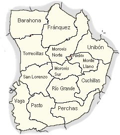
Like all municipalities of Puerto Rico, Morovis is subdivided into barrios. The municipal buildings, central square and large Catholic church are located near the center of the municipality, in a small barrio referred to as "el pueblo".[16][17][18]
Sectors
Barrios (which are like minor civil divisions)[19] in turn are further subdivided into smaller local populated place areas/units called sectores (sectors in English). The types of sectores may vary, from normally sector to urbanización to reparto to barriada to residencial, among others.[20][21][22][23]
Special Communities
Of the 742 places on the list of Comunidades Especiales de Puerto Rico, the following barrios, communities, sectors, or neighborhoods were in Morovis: Barrio Vaga, Santo Domingo-Pellejas, Ensanche, Parcelas Cuchillas, Comunidad José Otero Claverol, Parcelas San Lorenzo, Parcelas Torrecillas, Patrón, Sector Invasiones de Torrecillas, Sector Jobos, Sector Riachuelo, Sector Rosado, Barrio Unibón, Sector Vietnam, and Villa Roca.[24]
Energy consortium
An Energy Consortium was signed in late February, 2019 by the mayors of Villalba, Orocovis, Morovis, Ciales and Barranquitas municipalities. The consortium is the first of its kind for the island. It is intended to have those municipalities work together to safeguard and create resilient, and efficient energy networks, with backups for their communities. This is part of the hurricane preparedness plan of these municipalities, which were hit particularly hard by Hurricane Maria on September 20, 2017.[25]
Morovis National (Veterans) Cemetery

A new Puerto Rico National Cemetery for veterans is being built in Morovis within a 247.5-acre parcel of land that can be accessed from Highway 137 at Km. 11.2. It is being built to replace the existing Puerto Rico National Cemetery located in Bayamón.[26][27] Construction was underway in 2019.[28]
Economy
Agriculture
- Coffee and cattle
- Hydroponics "Cilantro"
Industry
- Light industry
Tourism
Landmarks and places of interest
A well-known landmark in Morovis is "The Red Bridge" (Puente Colorao). It's an iron bridge which was built in 1912 and is located on PR-155 in barrio Morovis Norte. Cuevas Las Cabachuelas (Cabachuelas Caves) is a cave system in Puerto Rico which opened for tourism in 2019. It is located between the municipalities of Morovis and Ciales, Puerto Rico[29] in the Cabachuelas Natural Reserve, established in 2012[30] and is of natural, cultural, archaeological, hydrological and geomorphological importance to Puerto Rico.[31] Guided tours are offered by the Diógenes Colón Gómez Cultural Center in Morovis by reservation.[29][32]
La Patria Bakery, home of the Pan de La Patita Echa', which translates to the "bread with its little crossed leg", is a 150-year old bakery that uses a brick oven for making bread. The bread has a curious name and look, resembling crossed legs.[33][34]
The Julia M. Cheverez Electronic Library is located in the recreational square in Pueblo.[35]
Each barrio has had a mural painted by a group of artists and ValorArte and the mural images are representative of values and ideas such as honor, peace, responsibility, leadership and culture.[36][37][38]
Culture
Festivals and events
Morovis celebrates its patron saint festival in July. The Fiestas Patronales de Nuestra Sra. del Carmen in honor of Our Lady of Mount Carmel is a religious and cultural celebration that generally features parades, games, artisans, amusement rides, regional food, and live entertainment.[39][1][6]
Other festivals and events include:
Demographics
| Historical population | |||
|---|---|---|---|
| Census | Pop. | %± | |
| 1900 | 11,309 | — | |
| 1910 | 12,446 | 10.1% | |
| 1920 | 14,660 | 17.8% | |
| 1930 | 17,332 | 18.2% | |
| 1940 | 19,167 | 10.6% | |
| 1950 | 19,291 | 0.6% | |
| 1960 | 18,094 | −6.2% | |
| 1970 | 19,059 | 5.3% | |
| 1980 | 21,142 | 10.9% | |
| 1990 | 25,288 | 19.6% | |
| 2000 | 29,965 | 18.5% | |
| 2010 | 32,610 | 8.8% | |
| U.S. Decennial Census[40] 1899 (shown as 1900)[41] 1910-1930[42] 1930-1950[43] 1960-2000[44] 2010[17] | |||
| Race - Morovis, Puerto Rico - 2000 Census[45] | ||
|---|---|---|
| Race | Population | % of Total |
| White | 27,917 | 93.2% |
| Black/African American | 894 | 3.0% |
| American Indian and Alaska Native | 61 | 0.2% |
| Asian | 21 | 0.1% |
| Native Hawaiian/Pacific Islander | 0 | 0% |
| Some other race | 643 | 2.1% |
| Two or more races | 422 | 1.4% |
Government

Carmen Maldonado, the mayor of Morovis in 2017 managed the devastation in Morovis caused by Hurricane Maria, by galvanizing the people to action and working with the central government of Puerto Rico to bring aid to the citizens of Morovis. At the time, the bridge collapse in Morovis' San Lorenzo barrio was often featured on national news.[46]
Transportation
There are 15 bridges in Morovis.[47] Major routes that go through Morovis include PR-137, PR-145, PR-155, PR-159, and PR-160.
Symbols
Flag
The flag of Morovis is divided vertically in two equal parts. The immediate one to the mast is yellow and has the eagle of the coat of arms, in this case with the head facing right toward the pole. The other half is divided in seven vertical stripes of equal width, four red ones alternated with three yellow ones.
Coat of arms
The coat of arms of the Municipality of Morovis is formed by an eagle in the left partition, which symbolizes San Juan Evangelista and sings in honor of the founder of the town, Don Juan Evangelista Rivera. The five "cuatros" (Puerto Rican instruments) observable in the right partition symbolize the fact that the town of Morovis is the main center of production of such typical Puerto Rican instruments. The shield in the center represents the Order of the Carmelite Nuns, and symbolizes as well the Virgen Carmen, matron of the town. The left half is a field of yellow color (yellow for gold) in which resides a saber (black) eagle, beak and claws in red, its head enclosed with a halo.
Notable moroveños
- Iluminado Davila Medina, cuatro musician
- Julio Negrón Rivera, master craftsman who makes the Puerto Rican cuatro, a musical instrument of Puerto Rico[48][49]
Gallery
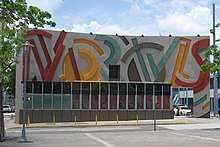
 USPS in Morovis
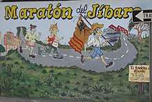 Marathon of the jíbaro mural in Morovis barrio-pueblo
 La Patria, old bakery
 Red Bridge (Puente Colorao) in Morovis Norte
 Symbols painted on wall in downtown Morovis
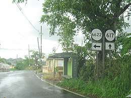 Signs for routes in Morovis
See also
- List of Puerto Ricans
- History of Puerto Rico
- Did you know-Puerto Rico?
References
- "Información del municipio". www2.pr.gov (in Spanish). 19 June 2020. Retrieved 19 June 2020.
- "MUNICIPIO AUTÓNOMO DE MOROVIS REVISIÓN PARCIAL AL PLAN TERRITORIAL" (PDF). Gobierno PR. Junta de Comunidad. Archived (PDF) from the original on 2018-12-02. Retrieved 2018-12-02.
- Tamacas, Carmen Molina. "Morovis abraza la esperanza" (in Spanish). El Diario NY. Archived from the original on 2019-06-01. Retrieved 2019-06-01.
- Tesauro de datos historicos: indice compendioso de la literatura histórica de Puerto Rico, incluyendo algunos datos inéditos, periodísticos y cartográficos. Tesauro de datos historicos: indice compendioso de la literatura histórica de Puerto Rico, incluyendo algunos datos inéditos, periodísticos y cartográficos (in Spanish). Impr. del Gobierno de Puerto Rico. 1949. p. 252. Retrieved 4 January 2020.
- Joseph Prentiss Sanger; Henry Gannett; Walter Francis Willcox (1900). Informe sobre el censo de Puerto Rico, 1899, United States. War Dept. Porto Rico Census Office (in Spanish). Imprenta del gobierno. p. 161.
- "Morovis Municipality". enciclopediapr.org. Fundación Puertorriqueña de las Humanidades (FPH). Archived from the original on 2019-06-21. Retrieved 2019-03-20.
- "María, un nombre que no vamos a olvidar. [Maria, a name we'll never forget.]". El Nuevo Día (in Spanish).
- García, Lyanne Meléndez. "Municipio anuncia reparación de puente afectado por huracán". Metro (in Spanish).
- "Con cuerda cruzan río peligroso en Puerto Rico" (in Spanish). CNN. 28 September 2017.
- "Bridge collapse strands Puerto Ricans - CNN Video" – via edition.cnn.com.
- "Lo que María se llevó en Morovis". Primera Hora (in Spanish).
- "Frustration Mounts Over Puerto Rico's 'New Normal' As Federal Troops Leave The Island". NPR.org.
- "Llegan desde Nueva York para reconstruir casas en Morovis". Primera Hora (in Spanish). 2 January 2019.
- "Facebook". www.facebook.com.
- https://heart911.org/projects/hurricane-maria-puerto-rico-response-ongoing/
- Gwillim Law (20 May 2015). Administrative Subdivisions of Countries: A Comprehensive World Reference, 1900 through 1998. McFarland. p. 300. ISBN 978-1-4766-0447-3. Retrieved 25 December 2018.
- Puerto Rico:2010:population and housing unit counts.pdf (PDF). U.S. Dept. of Commerce Economics and Statistics Administration U.S. Census Bureau. 2010. Archived (PDF) from the original on 2017-02-20. Retrieved 2019-08-02.
- "Map of Morovis at the Wayback Machine" (PDF). Archived from the original (PDF) on 2018-03-24. Retrieved 2018-12-29.
- "US Census Barrio-Pueblo definition". factfinder.com. US Census. Archived from the original on 13 May 2017. Retrieved 5 January 2019.
- "Agencia: Oficina del Coordinador General para el Financiamiento Socioeconómico y la Autogestión (Proposed 2016 Budget)". Puerto Rico Budgets (in Spanish). Retrieved 28 June 2019.
- Rivera Quintero, Marcia (2014), El vuelo de la esperanza: Proyecto de las Comunidades Especiales Puerto Rico, 1997-2004 (first ed.), San Juan, Puerto Rico Fundación Sila M. Calderón, ISBN 978-0-9820806-1-0
- "Leyes del 2001". Lex Juris Puerto Rico (in Spanish). Retrieved 24 June 2020.
- "PRECINTO ELECTORAL MOROVIS 020" (PDF). Comisión Estatal de Elecciones (in Spanish). PR Government. 8 October 2019. Retrieved 24 June 2020.
- Rivera Quintero, Marcia (2014), El vuelo de la esperanza:Proyecto de las Comunidades Especiales Puerto Rico, 1997-2004 (First ed.), San Juan, Puerto Rico Fundación Sila M. Calderón, p. 273, ISBN 978-0-9820806-1-0
- Vazquez, Priscilla. "Asociación de Industriales de Puerto Rico". Industriales Puerto Rico. Archived from the original on 2019-03-12. Retrieved 2019-03-16.
- "Puerto Rico National Cemetery Replacement Morovis, Puerto Rico" (PDF). U.S. Dept. of Veterans Affairs. U.S. Dept. of Veterans Affairs. Archived (PDF) from the original on 2017-05-13. Retrieved 2019-06-13.
- "A claim for better health services". El Nuevo Dia. 28 May 2019. Archived from the original on 25 June 2019. Retrieved 13 June 2019.
- "Comienza construcción nuevo cementerio nacional de Puerto Rico en Morovis". www.efe.com (in Spanish). 25 January 2019. Retrieved 26 June 2020.
- "Nueva opción al turismo para explorar cuevas en la isla" (in Spanish). Primera Hora. Archived from the original on 2019-05-07. Retrieved 2019-05-11.
- "Nuestras áreas naturales protegidas: tesoro ecológico de Puerto Rico" (in Spanish). DRNA. 13 June 2017. Archived from the original on 7 May 2019. Retrieved 11 May 2019.
- "Atractivo de clase mundial la Reserva Natural Las Cabachuelas" (in Spanish). 26 September 2013. Archived from the original on 7 May 2019. Retrieved 11 May 2019.
- Ríos, Melissa Cruz. "Morovis apuesta al ecoturismo". El Vocero de Puerto Rico (in Spanish). Archived from the original on 2019-06-01. Retrieved 2019-06-01.
- "La tradición de La Patita Echá" (in Spanish). Archived from the original on 2019-05-11. Retrieved 2019-05-11.
- "El pan de la "pata echa" de Morovis". El Nuevo Dia. 14 July 2011. Archived from the original on 11 May 2019. Retrieved 11 May 2019.
- "Morovis Municipality - Municipalities". EnciclopediaPR. Archived from the original on 2019-06-21. Retrieved 2019-03-20.
- Maldonado Feliciano, Brian A. (31 July 2019). "Realizarán 15 murales simultáneamente en Morovis [15 murals will be simultaneously completed in Morovis ]". El Foro de Puerto Rico (in Spanish). Retrieved 20 June 2020.
- "Video of murals in Morovis' barrios". Official Morovis Municipality on FB. Morovis Municipality. 20 August 2019. Retrieved 20 June 2020.
- "Morovis estrena 15 murales en proyecto cultural". Latina Travellina (in Spanish). 1 July 2019. Retrieved 20 June 2020.
- "Puerto Rico Festivales, Eventos y Actividades en Puerto Rico". Puerto Rico Hoteles y Paradores (in Spanish). Retrieved 2020-07-17.
- "U.S. Decennial Census". United States Census Bureau. Archived from the original on February 13, 2020. Retrieved September 21, 2017.
- "Report of the Census of Porto Rico 1899". War Department Office Director Census of Porto Rico. Archived from the original on July 16, 2017. Retrieved September 21, 2017.
- "Table 3-Population of Municipalities: 1930 1920 and 1910" (PDF). United States Census Bureau. Archived (PDF) from the original on August 17, 2017. Retrieved September 21, 2017.
- "Table 4-Area and Population of Municipalities Urban and Rural: 1930 to 1950" (PDF). United States Census Bureau. Archived (PDF) from the original on August 30, 2015. Retrieved September 21, 2014.
- "Table 2 Population and Housing Units: 1960 to 2000" (PDF). United States Census Bureau. Archived (PDF) from the original on July 24, 2017. Retrieved September 21, 2017.
- "Ethnic/Racial demographics, 2000 census" (PDF). Archived (PDF) from the original on 2008-02-16. Retrieved 2008-05-27.
- AP. "Iniciativa Hecho en Morovis para mercadear producción agrícola". El Vocero de Puerto Rico. Archived from the original on 2019-05-13. Retrieved 2019-05-13.
- "Morovis Bridges". National Bridge Inventory Data. US Dept. of Transportation. Archived from the original on 20 February 2019. Retrieved 19 February 2019.
- "Julio Negrón-Rivera". NEA. 24 January 2013. Archived from the original on 26 April 2019. Retrieved 10 March 2019.
- "Puerto Rican; Julio Negron Rivera- Traditional Rosario from Area, Other Traditional Jibaro Music [sound recording]". Smithsonian Institution.