Wooroonooran, Queensland
Wooroonooran is a locality split among the Cairns Region, the Cassowary Coast Region, and the Tablelands Region in Queensland, Australia.[2][3][4] In the 2016 census, Wooroonooran had no population.[1]
| Wooroonooran Queensland | |
|---|---|
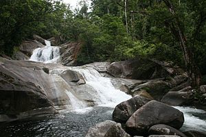
 Josephine Falls in Wooroonooran, 2007 | |
 Wooroonooran | |
| Coordinates | 17.3911°S 145.8202°E |
| Population | 0 (2016 census)[1] |
| Postcode(s) | 4860 |
| LGA(s) | |
| State electorate(s) | Hill |
| Federal Division(s) | Kennedy |
Geography


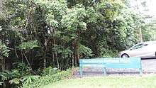
The locality is entirely within the Wooroonooran National Park (part of the Wet Tropics World Heritage Area), although the national park extends beyond the boundaries of the locality. As a consequence, the land is undeveloped apart from a very limited number of walking tracks and visitor amenities. The land is extremely mountainous containing numerous peaks, including Mount Bartle Frere (Queensland's highest peak), and numerous waterfalls, including the Josephine Falls and Fishery Falls (17.1833°S 145.8667°E).[5][6][7][8]
The locality is very irregularly shaped and is approx 59 km from its northernmost point to its southernmost point and approx 38 km from its easternmost point to its westernmost point. Due to the vast size of this locality, it has numerous adjacent localities including (clockwise) Gordonvale (to the north), Aloomba, Fishery Falls, Bellenden Ker, Babinda, Mirriwinni (to the east), Bartle Frere, Woopen Creek, Ngatjan, Nerada, East Palmerston, Palmerston (to the south), Middlebrook, Mungalli, Ellinja, Millaa Millaa, Tarzali, Glen Allyn (to the west), Topaz, Butchers Creek, Gadgarra, and Goldsborough.[5]
References
- Australian Bureau of Statistics (27 June 2017). "Wooroonooran (SSC)". 2016 Census QuickStats. Retrieved 22 April 2018.

- "Wooroonooran - locality in Cairns Region (entry 48942)". Queensland Place Names. Queensland Government. Retrieved 29 December 2017.
- "Wooroonooran - locality in Cassowary Coast Region (entry 45771)". Queensland Place Names. Queensland Government. Retrieved 29 December 2017.
- "Wooroonooran - locality in Tablelands Region (entry 48943)". Queensland Place Names. Queensland Government. Retrieved 31 December 2017.
- "Queensland Globe". State of Queensland. Retrieved 22 April 2018.
- "Wet Tropics parks". Department of National Parks, Sport and Racing. Queensland Government. 9 May 2012. Archived from the original on 7 April 2018. Retrieved 22 April 2018.
- "About Josephine Falls". Department of National Parks, Sport and Racing. Queensland Government. 28 March 2017. Archived from the original on 13 March 2018. Retrieved 22 April 2018.
- "Fishery Falls - waterfall in Cairns Region (entry 12540)". Queensland Place Names. Queensland Government. Retrieved 15 May 2018.