Kewarra Beach
Kewarra Beach is a coastal suburb of Cairns in the Cairns Region, Queensland, Australia.[2] At the 2016 Australian Census the suburb recorded a population of 5,652.[1]
| Kewarra Beach Queensland | |||||||||||||||
|---|---|---|---|---|---|---|---|---|---|---|---|---|---|---|---|
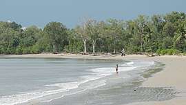 Beach looking south towards Taylor Point, 2018 | |||||||||||||||
 Kewarra Beach | |||||||||||||||
| Coordinates | 16.7875°S 145.6763°E | ||||||||||||||
| Population | 5,652 (2016 census)[1] | ||||||||||||||
| • Density | 844/km2 (2,185/sq mi) | ||||||||||||||
| Postcode(s) | 4879 | ||||||||||||||
| Area | 6.7 km2 (2.6 sq mi) | ||||||||||||||
| LGA(s) | Cairns Region | ||||||||||||||
| State electorate(s) | Barron River | ||||||||||||||
| Federal Division(s) | Leichhardt | ||||||||||||||
| |||||||||||||||
Geography
Kewarra Beach is bordered by the Coral Sea to the east and Kuranda National Park to the west. The Captain Cook Highway passes through the suburb from the south-west to the north.[3]
History
Kewarra Beach is situated in the Djabugay (Tjapukai) traditional Aboriginal country. [4] The origin of the suburb name is from an Aboriginal word 'kewarra', meaning 'at the foot of the rainbow'. [5]
The area was primarily utilised for growing sugar cane until the suburb was developed in the 1970s and 90s. The western side of the highway was developed with a golf course (Paradise Palms) with housing to the north and south.[6]
Trinity Anglican School opened its Kewarra Beach campus in 2002.[7]
Facilities
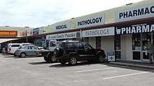
A small shopping centre is located on Poolwood Road.
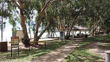
The foreshore reserve, Pelican Park, adjoins the beach. It has a swimming enclosure that excludes marine stingers at the north end.[6] Other reserves include Brolga Park and Crocodile Park.[8]
Tourist-oriented developments include Kewarra Beach Resort and Paradise Palms Country Club and Resort.[6][8]
Education
Trinity Anglican School is a private primary (Prep-6) campus at Poolwood Road (16.7888°S 145.6829°E) of the Trinity Anglican School at White Rock (which opened in 1983).[9][10][11]
Transport
Kewarra Beach is 20 kilometres (12 mi) north of Cairns via the Captain Cook Highway.[6] Sunbus bus route 111 originates on Cottlesloe Drive and terminates at Cairns Central Shopping Centre via Trinity Beach and Trinity Park.[12]
References
- Australian Bureau of Statistics (27 June 2017). "Kewarra Beach (State Suburb)". 2016 Census QuickStats. Retrieved 25 March 2018.

- "Kewarra Beach - suburb in Cairns Region (entry 48697)". Queensland Place Names. Queensland Government. Retrieved 30 July 2017.
- "Queensland Globe". State of Queensland. Retrieved 6 May 2018.
- "First people cultural history". Cairns Regional Council. Retrieved 23 June 2020.
- "Cairns Heritage: K Suburbs" (PDF). Cairns Regional Council. Retrieved 23 June 2020.
- "Kewarra Beach". Centre for the Government of Queensland. Archived from the original on 5 September 2013. Retrieved 14 July 2013.
- Queensland Family History Society (2010), Queensland schools past and present (Version 1.01 ed.), Queensland Family History Society, ISBN 978-1-921171-26-0
- "Kewarra Beach community profile". profile.id. Archived from the original on 29 September 2013. Retrieved 14 July 2013.
- "State and non-state school details". Queensland Government. 9 July 2018. Archived from the original on 21 November 2018. Retrieved 21 November 2018.
- "Trinity Anglican School". Retrieved 21 November 2018.
- "About TAS". Trinity Grammar School. Archived from the original on 27 July 2013. Retrieved 14 July 2013.
- "Information about zones, fares, tickets, ticket types, ticket prices, concessions etc". Sunbus. Archived from the original on 30 June 2013. Retrieved 14 July 2013.
External links
![]()