Manoora, Queensland
Manoora is a suburb of Cairns in the Cairns Region, Queensland, Australia.[3] In the 2016 census Manoora had a population of 6,027 people.[1]
| Manoora Cairns, Queensland | |||||||||||||||
|---|---|---|---|---|---|---|---|---|---|---|---|---|---|---|---|
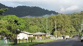 Macilwraith Street, looking west, 2018 | |||||||||||||||
 Manoora | |||||||||||||||
| Coordinates | 16.9186°S 145.7358°E | ||||||||||||||
| Population | 6,027 (2016 census)[1] | ||||||||||||||
| • Density | 2,620/km2 (6,790/sq mi) | ||||||||||||||
| Postcode(s) | 4870 | ||||||||||||||
| Area | 2.3 km2 (0.9 sq mi) | ||||||||||||||
| LGA(s) | Cairns Region | ||||||||||||||
| State electorate(s) | Cairns | ||||||||||||||
| Federal Division(s) | Leichhardt[2] | ||||||||||||||
| |||||||||||||||
Geography
Maroora is west of the Cairns city centre in Far North Queensland. It straddles the Cairns Western Arterial Road (state route 91).[4] Pease Street contains the commercial centre in Manoora including a shopping centre, tavern and fast food franchise. At the 2011 census, Manoora had a population of approximately 6,000.[1]
History
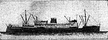
The suburb was named after HMAS Manoora, which was in turn named after the town of Manoora in South Australia. The ship was built in Scotland in 1935 as a coastal steamer for the Adelaide Steamship Company and regularly visited Cairns, and entered service with the Royal Australian Navy in the World War II.[3]
Pau Enterprises Indigenous Corporation was established in 2015 to manage and maintain the Pau family native title lands and interests on Darnley Island. It also seeks to create social enterprises on Darnley Island and other locations where community members have migrated to, such as Cairns.[5] Their Cairns initiatives are organised from their Manoora office.[6]
References
- Australian Bureau of Statistics (27 June 2017). "Manoora (Qld) (State Suburb)". 2016 Census QuickStats. Retrieved 18 April 2018.

- "Profile of the electoral division of Leichhardt (Qld)". 23 September 2013. Retrieved 22 December 2014.
- "Manoora - suburb in Cairns Region (entry 48741)". Queensland Place Names. Queensland Government. Retrieved 26 June 2017.
- Google (22 December 2014). "Manoora QLD 4870" (Map). Google Maps. Google. Retrieved 22 December 2014.
- "The Proposal Summary: Outline of Project Goals" (PDF). Archived (PDF) from the original on 26 April 2018. Retrieved 26 April 2018.
- "Pau Enterprises Indigenous Corporation". Office of the Registrar of Indigenous Corporations. Australian Government. Retrieved 3 May 2018.