Aeroglen
Aeroglen is a coastal suburb of Cairns in the Cairns Region, Queensland, Australia.[2] It is approximately 3 miles north of the Cairns City centre.
| Aeroglen Cairns, Queensland | |||||||||||||||
|---|---|---|---|---|---|---|---|---|---|---|---|---|---|---|---|
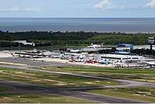
Aeroglen and Cairns Airport with Mount Whitfield directly behind it, as seen from the Coral Sea | |||||||||||||||
 Aeroglen | |||||||||||||||
| Coordinates | 16.8761°S 145.7597°E | ||||||||||||||
| Population | 403 (2016 census)[1] | ||||||||||||||
| • Density | 29.20/km2 (75.6/sq mi) | ||||||||||||||
| Postcode(s) | 4870 | ||||||||||||||
| Area | 13.8 km2 (5.3 sq mi) | ||||||||||||||
| LGA(s) | Cairns Region | ||||||||||||||
| State electorate(s) | Cairns | ||||||||||||||
| Federal Division(s) | Leichhardt | ||||||||||||||
| |||||||||||||||
Geography

Aeroglen is located on a slope at the foot of the Mount Whitfield Conservation Park. Most of the suburb is taken up by the Cairns International Airport and the name Aeroglen is a reference to the airport. There is also a village opposite the airport, on the western side of the Captain Cook Highway.[3]
History
In the 2011 census, Aeroglen had a population of 403 people.[4]
Population
In the 2016 Census, there were 403 people in Aeroglen. 77.6% of people were born in Australia and 86.8% of people only spoke English at home. The most common response for religion in Aeroglen was No Religion at 38.2% of the population.[1]
References
- Australian Bureau of Statistics (27 June 2017). "Aeroglen". 2016 Census QuickStats. Retrieved 6 January 2018.

- "Aeroglen (entry 48491)". Queensland Place Names. Queensland Government. Retrieved 16 November 2014.
- "Aeroglen Queensland". Google Maps. Google. Retrieved 20 November 2014.
- Australian Bureau of Statistics (31 October 2012). "Aeroglen". 2011 Census QuickStats. Retrieved 20 November 2014.

External links
| Wikimedia Commons has media related to Aeroglen, Queensland. |
- Aeroglen Brochure Cairns Regional Council