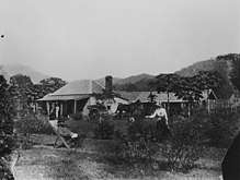
Glen Boughton
Glen Boughton is a locality in the Cairns Region, Queensland, Australia.[2] In 2016 census, Glen Boughton had a population of 28.[1]
| Glen Boughton Queensland | |||||||||||||||
|---|---|---|---|---|---|---|---|---|---|---|---|---|---|---|---|
 Glen Boughton | |||||||||||||||
| Coordinates | 16.945°S 145.8236°E | ||||||||||||||
| Population | 28 (2016 census)[1] | ||||||||||||||
| • Density | 4.75/km2 (12.3/sq mi) | ||||||||||||||
| Postcode(s) | 4871 | ||||||||||||||
| Area | 5.9 km2 (2.3 sq mi) | ||||||||||||||
| Location |
| ||||||||||||||
| LGA(s) | Cairns Region | ||||||||||||||
| State electorate(s) | Mulgrave | ||||||||||||||
| Federal Division(s) | Kennedy | ||||||||||||||
| |||||||||||||||
Geography
Contrary to the Queensland Government's usual guidelines on locality boundaries, Glen Boughton is a locality entirely within another locality (East Trinity).[3] The locality is entirely freehold land with approximately half of it developed. The western part of the locality the land is flat (almost at sea level) and is used for farming, predominantly sugarcane. The eastern part of the locality is mountainous rising to approximately 400 metres at the eastern boundary (the Murray Prior Range);[4] it is undeveloped land. Hills Creek flows from east to west through the locality and after passing through East Trinity has its mouth at the Trinity Inlet.[5] Although Cairns City is only 5 kilometres (3.1 mi) NW from Glen Boughton, the road distance between them is 35.2 kilometres (21.9 mi) via Gordonvale as there are no bridges over the Trinity Inlet.[6]
History

By 1887, Messrs Clayton and John Hill had established a farm called Glen Boughton Estate (presumably the origin of the locality's name) raising cattle on cultivated grasses and were obtaining dairy cows as Cairns was experiencing increased demand for milk and butter.[7] Their original plan was to grow sugarcane but changes in legislation about the use of Kanaka workers meant they decided to switch to dairying.[8] In 1888 the Glen Boughton farm consisted of 110 acres (45 ha) of which 260 acres (110 ha) were cleared with 120 acres being let to a Chinese gardener. They were experimenting with various kinds of fodder crop to see which was most productive on their land.[9][10] Clayton appears to have left the farm to the sole owernship of John Hill by 1900; John Hill and his wife Mary Jane continued the farm until both had died (1933 and 1948 respectively).[8][11]
References
- Australian Bureau of Statistics (27 June 2017). "Glen Boughton (SSC)". 2016 Census QuickStats. Retrieved 14 March 2018.

- "Glen Boughton - locality in Cairns Region (entry 48650)". Queensland Place Names. Queensland Government. Retrieved 29 December 2017.
- "How places are named: Defining boundaries and extent: Locality boundaries". Queensland Government. 28 October 2016. Archived from the original on 14 March 2018. Retrieved 14 March 2018.
- "Murray Prior Range - mountain range in Yarrabah Aboriginal Shire (entry 23615)". Queensland Place Names. Queensland Government. Retrieved 14 March 2018.
- "Queensland Globe". State of Queensland. Retrieved 14 March 2018.
- "From Cairns City to Glen Boughton". Google Maps. Retrieved 14 March 2018.
- "Local Items". Cairns Post. V (233). Queensland, Australia. 30 July 1887. p. 2. Retrieved 14 March 2018 – via National Library of Australia.
- "FAR NORTHERN PIONEER". The Northern Herald. LXXX (1033). Queensland, Australia. 4 February 1933. p. 7. Retrieved 14 March 2018 – via National Library of Australia.
- "Dairy Farming in Cairns". Cairns Post. V (292). Queensland, Australia. 29 February 1888. p. 3. Retrieved 14 March 2018 – via National Library of Australia.
- "PRODUCING INTERESTS". The Brisbane Courier. LXI (14, 649). Queensland, Australia. 24 December 1904. p. 15. Retrieved 14 March 2018 – via National Library of Australia.
- "OBITUARY. MBS. MARY JANE HULL". Cairns Post (14, 453). Queensland, Australia. 1 July 1948. p. 5. Retrieved 14 March 2018 – via National Library of Australia.