Volckerinckhove
Volckerinckhove is a commune in the Nord department in northern France.
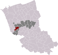
Volckerinckhove location in arrondissement of Dunkirk and canton of Wormhout
Volckerinckhove | |
|---|---|
 The church in Volckerinckhove | |
.svg.png) Coat of arms | |
Location of Volckerinckhove 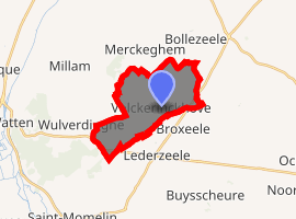
| |
 Volckerinckhove  Volckerinckhove | |
| Coordinates: 50°50′22″N 2°18′23″E | |
| Country | France |
| Region | Hauts-de-France |
| Department | Nord |
| Arrondissement | Dunkirk |
| Canton | Wormhout |
| Intercommunality | Hauts de Flandre |
| Government | |
| • Mayor (2014-2020) | Jean-Paul Monsterleet |
| Area 1 | 9.88 km2 (3.81 sq mi) |
| Population (2017-01-01)[1] | 567 |
| • Density | 57/km2 (150/sq mi) |
| Demonym(s) | Volckerinckhovois |
| Time zone | UTC+01:00 (CET) |
| • Summer (DST) | UTC+02:00 (CEST) |
| INSEE/Postal code | 59628 /59470 |
| Elevation | 15–61 m (49–200 ft) (avg. 30 m or 98 ft) |
| 1 French Land Register data, which excludes lakes, ponds, glaciers > 1 km2 (0.386 sq mi or 247 acres) and river estuaries. | |
Politics
Presidential Elections 2nd Round
| Election | Winning Candidate | Party | % | |
|---|---|---|---|---|
| 2017 | Emmanuel Macron | En Marche! | 56.36 | |
| 2012 | Nicolas Sarkozy | UMP | 61.93 | |
| 2007 | Nicolas Sarkozy | UMP | 63.82 | |
| 2002 | Jacques Chirac | RPR | 75.42 | |
Heraldry
Arms of Volckerinckhove |
The arms of Volckerinckhove are blazoned : Sable, on a chief argent, 2 mullets of 6 points pierced gules. |
gollark: Some online friends did vaguely express interest in running our IRC network over ham radio instead of boring IP networks. That might be neat.
gollark: It's on my list of things to eternally never get round to doing.
gollark: > In mid-2019, part of IPv4 range was sold off for conventional use, due to IPv4 address exhaustion. I see.
gollark: /9 means that the first 9 bits of the address are the same for the things within the block of IPs.
gollark: 2^23 IPv4 addresses.
See also
References
- "Populations légales 2017". INSEE. Retrieved 6 January 2020.
- http://www.lemonde.fr/data/france/presidentielle-2017//
| Wikimedia Commons has media related to Volckerinckhove. |
| Authority control |
|
|---|
This article is issued from Wikipedia. The text is licensed under Creative Commons - Attribution - Sharealike. Additional terms may apply for the media files.