Sémeries
Sémeries is a commune in the Nord department in northern France.
Sémeries | |
|---|---|
_%C3%A9glise_fa%C3%A7ade.jpg) The church in Sémeries | |
.svg.png) Coat of arms | |
Location of Sémeries 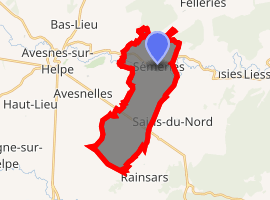
| |
 Sémeries  Sémeries | |
| Coordinates: 50°07′13″N 4°00′03″E | |
| Country | France |
| Region | Hauts-de-France |
| Department | Nord |
| Arrondissement | Avesnes-sur-Helpe |
| Canton | Fourmies |
| Intercommunality | Communauté de communes du Cœur de l'Avesnois |
| Government | |
| • Mayor (2014-2020) | Jean-Luc Defroidmont |
| Area 1 | 13.46 km2 (5.20 sq mi) |
| Population (2017-01-01)[1] | 546 |
| • Density | 41/km2 (110/sq mi) |
| Time zone | UTC+01:00 (CET) |
| • Summer (DST) | UTC+02:00 (CEST) |
| INSEE/Postal code | 59562 /59440 |
| Elevation | 148–222 m (486–728 ft) (avg. 206 m or 676 ft) |
| 1 French Land Register data, which excludes lakes, ponds, glaciers > 1 km2 (0.386 sq mi or 247 acres) and river estuaries. | |
Sémeries sits in the valley of the Helpe in the Avesnois Regional Park in an area called the little Switzerland of the North.
History
The rights of the village were given in 1095 by Thierry d'Avesnes to Abbey Liessies who retained it until the French Revolution.
Heraldry
Arms of Sémeries |
The arms of Sémeries are blazoned : Argent, a boar's head erased sable, armed argent langued gules. (Liessies, Sains-du-Nord and Sémeries use the same arms.) |
gollark: 6) supersedes it in some cases, but it was wisely written to not allow bylaw alteration without unanimous agreement.
gollark: > 4) this set of bylaws can be modified by the council with unanimous agreement
gollark: <#821522631269548092> suggests we can't, but I guess we can just ignore it.
gollark: Does GEORGE policy actually allow us to alter GEORGE policy without agreement from all council members?
gollark: I've been in communication with someone who has been in communication with someone who says they are at least not *dead*, but also anomalously not on the internet.
See also
References
- "Populations légales 2017". INSEE. Retrieved 6 January 2020.
| Wikimedia Commons has media related to Sémeries. |
This article is issued from Wikipedia. The text is licensed under Creative Commons - Attribution - Sharealike. Additional terms may apply for the media files.