Raucourt-au-Bois
Raucourt-au-Bois is a commune in the Nord department in northern France.
Raucourt-au-Bois | |
|---|---|
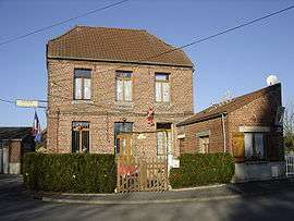 The town hall in Raucourt-au-Bois | |
.svg.png) Coat of arms | |
Location of Raucourt-au-Bois 
| |
 Raucourt-au-Bois  Raucourt-au-Bois | |
| Coordinates: 50°12′38″N 3°39′40″E | |
| Country | France |
| Region | Hauts-de-France |
| Department | Nord |
| Arrondissement | Avesnes-sur-Helpe |
| Canton | Avesnes-sur-Helpe |
| Intercommunality | Communauté de communes du pays de Mormal |
| Government | |
| • Mayor (2014-2020) | Jean-Pierre Noël |
| Area 1 | 1.04 km2 (0.40 sq mi) |
| Population (2017-01-01)[1] | 173 |
| • Density | 170/km2 (430/sq mi) |
| Time zone | UTC+01:00 (CET) |
| • Summer (DST) | UTC+02:00 (CEST) |
| INSEE/Postal code | 59494 /59530 |
| Elevation | 131–148 m (430–486 ft) (avg. 103 m or 338 ft) |
| 1 French Land Register data, which excludes lakes, ponds, glaciers > 1 km2 (0.386 sq mi or 247 acres) and river estuaries. | |
Heraldry
Arms of Raucourt-au-Bois |
The arms of Raucourt-au-Bois are blazoned : Per pale highly indented argent and gules. (Cagnoncles, Landas, Raucourt-au-Bois and Thun-Saint-Amand use the same arms.) |
gollark: Suuuuuuure.
gollark: Presumably it's homework in a particular language.
gollark: Rotate tetrationally.
gollark: No, I mean that they probably won't pay it back immediately at least some of the time.
gollark: Thusly you may need to actually be specific.
See also
References
- "Populations légales 2017". INSEE. Retrieved 6 January 2020.
| Wikimedia Commons has media related to Raucourt-au-Bois. |
| Authority control |
|
|---|
This article is issued from Wikipedia. The text is licensed under Creative Commons - Attribution - Sharealike. Additional terms may apply for the media files.