Le Doulieu
Le Doulieu is a commune in the Nord department in northern France.
Le Doulieu | |
|---|---|
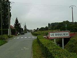 The road into Le Doulieu | |
_Nord-France.svg.png) Coat of arms | |
Location of Le Doulieu 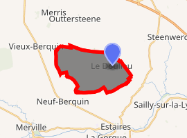
| |
 Le Doulieu  Le Doulieu | |
| Coordinates: 50°40′57″N 2°43′07″E | |
| Country | France |
| Region | Hauts-de-France |
| Department | Nord |
| Arrondissement | Dunkerque |
| Canton | Bailleul |
| Intercommunality | Communauté de communes de Flandre Intérieure |
| Government | |
| • Mayor (2014-2020) | Dominique Walbrou |
| Area 1 | 11.74 km2 (4.53 sq mi) |
| Population (2017-01-01)[1] | 1,478 |
| • Density | 130/km2 (330/sq mi) |
| Demonym(s) | Doulieusiens, Doulieusiennes |
| Time zone | UTC+01:00 (CET) |
| • Summer (DST) | UTC+02:00 (CEST) |
| INSEE/Postal code | 59180 /59940 |
| Elevation | 15–19 m (49–62 ft) (avg. 16 m or 52 ft) |
| 1 French Land Register data, which excludes lakes, ponds, glaciers > 1 km2 (0.386 sq mi or 247 acres) and river estuaries. | |
Heraldry
Arms of Le Doulieu |
The arms of Le Doulieu are blazoned : Gules, a saltire vair. (Le Doulieu and Eecke use the same arms.) |
gollark: >pickup
gollark: <:apioform:812013353165389875>
gollark: Bye then.
gollark: Try not falling off your bed instead.
gollark: https://media.discordapp.net/attachments/763525085508009984/779810805469282304/unknown.png
See also
References
- "Populations légales 2017". INSEE. Retrieved 6 January 2020.
| Wikimedia Commons has media related to Le Doulieu. |
| Authority control |
|
|---|
This article is issued from Wikipedia. The text is licensed under Creative Commons - Attribution - Sharealike. Additional terms may apply for the media files.