Leers
Leers is a commune in the Nord department in northern France.
Leers | |
|---|---|
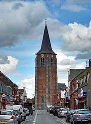 The church in Leers | |
 Coat of arms | |
Location of Leers 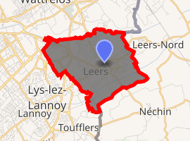
| |
 Leers  Leers | |
| Coordinates: 50°40′57″N 3°14′41″E | |
| Country | France |
| Region | Hauts-de-France |
| Department | Nord |
| Arrondissement | Lille |
| Canton | Roubaix-2 |
| Intercommunality | Métropole Européenne de Lille |
| Government | |
| • Mayor (2016-2020) | Jean-Philippe Andriès |
| Area 1 | 5.4 km2 (2.1 sq mi) |
| Population (2017-01-01)[1] | 9,473 |
| • Density | 1,800/km2 (4,500/sq mi) |
| Time zone | UTC+01:00 (CET) |
| • Summer (DST) | UTC+02:00 (CEST) |
| INSEE/Postal code | 59339 /59115 |
| Elevation | 16–37 m (52–121 ft) (avg. 37 m or 121 ft) |
| 1 French Land Register data, which excludes lakes, ponds, glaciers > 1 km2 (0.386 sq mi or 247 acres) and river estuaries. | |
It is part of the Urban Community of Lille Métropole, and is about 15 km (9.3 mi) northeast of Lille.
Heraldry
Arms of Leers |
The arms of Leers are blazoned : Sable, 4 keys argent. (Leers and Saint-Pierre-Brouck use the same arms.) |
gollark: I tested it but there wasn't much to do there.
gollark: Now my reign of terror can begin!
gollark: And I didn't have to do any actual training!
gollark: μgollark: Remy.
gollark: Yes, you cannot send empty messages.
See also
References
- "Populations légales 2017". INSEE. Retrieved 6 January 2020.
| Wikimedia Commons has media related to Leers (Nord). |
.svg.png)
| Authority control |
|
|---|
This article is issued from Wikipedia. The text is licensed under Creative Commons - Attribution - Sharealike. Additional terms may apply for the media files.