Hornaing
Hornaing is a communes in the Nord department in northern France.
Hornaing | |
|---|---|
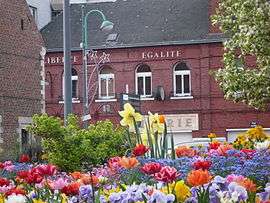 The town hall of Hornaing | |
_Nord-France.svg.png) Coat of arms | |
Location of Hornaing 
| |
 Hornaing  Hornaing | |
| Coordinates: 50°22′07″N 3°20′10″E | |
| Country | France |
| Region | Hauts-de-France |
| Department | Nord |
| Arrondissement | Douai |
| Canton | Sin-le-Noble |
| Intercommunality | Communauté de communes Cœur d'Ostrevent |
| Government | |
| • Mayor (2014-2020) | Frédéric Delannoy |
| Area 1 | 8.95 km2 (3.46 sq mi) |
| Population (2017-01-01)[1] | 3,553 |
| • Density | 400/km2 (1,000/sq mi) |
| Time zone | UTC+01:00 (CET) |
| • Summer (DST) | UTC+02:00 (CEST) |
| INSEE/Postal code | 59314 /59171 |
| Elevation | 16–45 m (52–148 ft) (avg. 23 m or 75 ft) |
| 1 French Land Register data, which excludes lakes, ponds, glaciers > 1 km2 (0.386 sq mi or 247 acres) and river estuaries. | |
Heraldry
Arms of Hornaing |
The arms of Hornaing are blazoned : Gules, a fess and in chief a vivre Or. [a vivre is a thin barrulet dancetty] (Gommegnies, Hornaing and Mastaing use the same arms.) |
gollark: We could incorporate "signalling" and "actually removing cliffs" ~~(by the way, please restock the cliff explosives thing with grenades)~~ (oops, wrong person, orbital bee strike inbound) and "proper bidirectional tracks".
gollark: When I have time (at precisely 15:48 ±17 hours) I SHALL rejoin and optimize our train network for greater trainocity.
gollark: Topright corner somewhere. You can set destinations.
gollark: If you click "trains" in the UI, you can control them.
gollark: I am now spying on you. Muahahaha.
See also
References
- "Populations légales 2017". INSEE. Retrieved 6 January 2020.
| Wikimedia Commons has media related to Hornaing. |
| Authority control |
|
|---|
This article is issued from Wikipedia. The text is licensed under Creative Commons - Attribution - Sharealike. Additional terms may apply for the media files.