U.S. Route 25 in South Carolina
U.S. Route 25 (US 25) is a U.S. Highway that travels from Brunswick, Georgia to the Kentucky-Ohio state line, where Covington, Kentucky meets Cincinnati, Ohio at the Ohio River. In the U.S. state of South Carolina, it begins as a 140.4-mile-long (226.0 km) highway that travels south to north in the western part of the state, serving the northern part of the Augusta metropolitan area, Greenwood, and Greenville on its path from North Augusta to North Carolina in the Saluda Mountains, near Travelers Rest.
| ||||
|---|---|---|---|---|
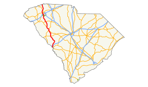 Route of US 25 in South Carolina highlighted in red | ||||
| Route information | ||||
| Maintained by SCDOT | ||||
| Length | 140.6 mi[1] (226.3 km) | |||
| Existed | 1927–present | |||
| Major junctions | ||||
| South end | ||||
| ||||
| North end | ||||
| Location | ||||
| Counties | Aiken, Edgefield, McCormick, Greenwood, Laurens, Greenville | |||
| Highway system | ||||
| ||||

Route description
ADHS corridor W
US 25, from I-85 to the North Carolina state line, is part of the Appalachian Development Highway System (ADHS), which is part of Appalachian Regional Commission (ARC). Of the 30.7-mile (49.4 km) section of US 25, only 22.9-mile (36.9 km) was authorized for ADHS funding. In the 2013 fiscal year, South Carolina completed Corridor W and also became the first state to complete its entire ADHS miles among all 13 Appalachian states.[2] The entire section of US 25 along Corridor W boasts a four-to-six-lane limited-access road, with interchanges at major intersections.
History
Established in 1927 as an original US highway, it was assigned to the entirety of SC 21, which was removed the following year. Traveling closely as it does today, it went from North Augusta to Travelers Rest, connecting the cities and towns of Edgefield, Greenwood, Ware Shoals, and Greenville.
In 1937, US 25 was rerouted in Greenville, moving onto College Avenue from Main Street to Buncombe Street. By 1961, US 25 was moved onto a new bypass east of North Augusta, leaving US 25 Bus. In 1963, Ware Shoals was bypassed east, leaving another US 25 Bus. In 1964, US 25 was rerouted onto new primary routing east of Travelers Rest, leaving Main Street to US 276 and Poinsett Highway downgraded to secondary (today now an unsigned US 25 Conn).[3][4]
By 1969, US 25 was rerouted onto a western bypass of Greenville, replacing SC 250; the old alignment was replaced by US 25 Bus. Also in the same year, US 25 was given its current eastern bypass around Greenwood, leaving US 25 Bus along its old alignment along Main and Montague Streets. In 1973, US 25 was rerouted in northern Greenville County onto new modern ascent along the Saluda Mountains; the old route was downgraded to secondary (Old Highway 25 - S-23-969).[4][5]
Junction list
| County | Location | mi[1] | km | Destinations | Notes | |||
|---|---|---|---|---|---|---|---|---|
| Aiken | North Augusta | 0.0 | 0.0 | Continuation from Georgia over the Savannah River | ||||
| 0.2 | 0.32 | 5th Street Bridge / River North Drive | ||||||
| 0.7 | 1.1 | North end of US 1 and east end of US 78/US 278 overlap | ||||||
| 1.6 | 2.6 | South end of SC 230 overlap | ||||||
| 2.1 | 3.4 | North end of SC 230 overlap | ||||||
| 3.8 | 6.1 | |||||||
| 4.8 | 7.7 | |||||||
| 6.4 | 10.3 | I-520 exit 22. | ||||||
| 7.2 | 11.6 | I-20 exit 5. | ||||||
| Edgefield | Trenton | 20.4 | 32.8 | North end of SC 121 overlap | ||||
| Edgefield | 26.1 | 42.0 | East end of SC 23 overlap | |||||
| 26.5 | 42.6 | West end of SC 23 overlap | ||||||
| 27.6 | 44.4 | |||||||
| | 30.7 | 49.4 | ||||||
| | 38.6 | 62.1 | ||||||
| McCormick |
No major junctions | |||||||
| Greenwood | | 53.7 | 86.4 | East end of US 178 overlap | ||||
| | 54.9 | 88.4 | ||||||
| | 55.4 | 89.2 | ||||||
| Greenwood | 56.6 | 91.1 | South end of US 221 overlap | |||||
| 57.7 | 92.9 | |||||||
| 61.3 | 98.7 | North end of US 221 and east end of SC 72 overlap | ||||||
| 62.9 | 101.2 | |||||||
| 63.5 | 102.2 | West end of SC 72 overlap | ||||||
| Hodges | 69.5 | 111.8 | West end of US 178 overlap | |||||
| | 70.3 | 113.1 | ||||||
| | 71.1 | 114.4 | ||||||
| Ware Shoals | 76.6 | 123.3 | ||||||
| Laurens | | 78.1 | 125.7 | Power House Road | ||||
| | 80.0 | 128.7 | ||||||
| Princeton | 86.4 | 139.0 | East end of US 76 overlap | |||||
| Greenville | | 87.6 | 141.0 | West end of US 76 overlap | ||||
| Ware Place | 97.3 | 156.6 | ||||||
| 97.4 | 156.8 | |||||||
| Canterbury | 102.4 | 164.8 | ||||||
| | 104.2 | 167.7 | I-185 exit 7. | |||||
| | 107.6 | 173.2 | ||||||
| | 110.0 | 177.0 | ||||||
| Gantt | 110.7 | 178.2 | I-185 exit 16 southbound. | |||||
| | 111.0 | 178.6 | I-185 exit 15 northbound. | |||||
| | 112.2 | 180.6 | ||||||
| | 113.5 | 182.7 | ||||||
| | 114.7 | 184.6 | ||||||
| | 115.1 | 185.2 | ||||||
| | 118.2 | 190.2 | ||||||
| Travelers Rest | 122.6 | 197.3 | East end of US 276 overlap; no northbound exit, southbound left exit | |||||
| 123.2 | 198.3 | West end of US 276 overlap; northbound left exit | ||||||
| 124.8 | 200.8 | Unsigned connector route | ||||||
| | 129.1 | 207.8 | ||||||
| | 129.9 | 209.1 | West end of SC 414 overlap | |||||
| | 130.0 | 209.2 | East end of SC 414 overlap; to North Greenville University and Campbell's Covered Bridge | |||||
| | 133.5 | 214.8 | ||||||
| | 134.3 | 216.1 | Old Highway 25 – Camp Old Indian, Saluda | To Poinsett Bridge | ||||
| | 140.6 | 226.3 | Continuation into North Carolina | |||||
1.000 mi = 1.609 km; 1.000 km = 0.621 mi
| ||||||||
See also


- Special routes of U.S. Route 25
References
- Google (June 29, 2013). "U.S. Route 25 in South Carolina" (Map). Google Maps. Google. Retrieved June 29, 2013.
- "Status of Corridors in South Carolina" (PDF). Appalachian Regional Commission. September 30, 2013. Retrieved June 29, 2014.
- General Highway Map, Greenville County, South Carolina (PDF) (Map). Cartography by SCDOT. South Carolina Department of Transportation. 1957. Retrieved April 7, 2014.
- General Highway Map, Greenville County, South Carolina (PDF) (Map). Cartography by SCDOT. South Carolina Department of Transportation. 1965. Retrieved April 7, 2014.
- General Highway Map, Greenville County, South Carolina (PDF) (Map). Cartography by SCDOT. South Carolina Department of Transportation. 1973. Retrieved April 7, 2014.
External links

- Mapmikey's South Carolina Highways Page: US 25
| Previous state: Georgia |
South Carolina | Next state: North Carolina |