South Carolina Highway 126
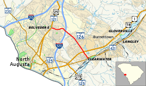
South Carolina Highway 126 (SC 126) is a primary state highway in the U.S. state of South Carolina. It directly links Belvedere with Clearwater.
| ||||
|---|---|---|---|---|
| Belvedere-Clearwater Road | ||||
 | ||||
| Route information | ||||
| Maintained by SCDOT | ||||
| Length | 4.20 mi[1] (6.76 km) | |||
| Existed | 1939–present | |||
| Major junctions | ||||
| West end | ||||
| ||||
| East end | ||||
| Location | ||||
| Counties | Aiken | |||
| Highway system | ||||
| ||||
Route description
SC 126 is a suburban highway that travels 4.2 miles (6.8 km) from U.S. Route 25 (US 25)/SC 121 in Belvedere to SC 421 in Clearwater. In both Belvedere and North Augusta, SC 126 is a four-lane with median; in Clearwater it only has two lanes. The entire route has few commercial entities, mainly functioning to connect neighborhoods in the area. It also has intermediate junctions with Interstate 520 (I-520) and US 1/US 78.[2]
History
SC 126 was established in 1939 as a new primary route and has remained unchanged since. The entire highway was paved by 1948 and widened in Belvedere and North Augusta by 2010.
Future
The remaining two-lane section of SC 126 in Clearwater is planned to be widened to four lanes; however, no time-table has been set.[3]
Junction list
The entire route is in Aiken County.
| Location | mi[1] | km | Destinations | Notes | |
|---|---|---|---|---|---|
| Belvedere | 0.00 | 0.00 | |||
| North Augusta | 1.28 | 2.06 | Exit 21 (I-520) | ||
| Clearwater | 3.55 | 5.71 | |||
| 4.20 | 6.76 | ||||
| 1.000 mi = 1.609 km; 1.000 km = 0.621 mi | |||||
See also


References
- South Carolina Department of Transportation: Statewide Highways 2012. Specifics: . Files: .
- Google (September 7, 2013). "South Carolina Highway 126" (Map). Google Maps. Google. Retrieved September 7, 2013.
- "Augusta Regional Transportation Study" (PDF). City of Augusta. March 7, 2013. p. 7. Retrieved September 7, 2013.
External links

- Mapmikey's South Carolina Highways Page: SC 120-129
