South Carolina Highway 283
South Carolina Highway 283 (SC 283) is a 17.8-mile-long (28.6 km) state highway in the U.S. state of South Carolina. The highway connects Plum Branch with rural areas of McCormick and Edgefield counties.
| ||||
|---|---|---|---|---|
 | ||||
| Route information | ||||
| Maintained by SCDOT | ||||
| Length | 17.84 mi[1] (28.71 km) | |||
| Major junctions | ||||
| West end | ||||
| East end | ||||
| Location | ||||
| Counties | McCormick, Edgefield | |||
| Highway system | ||||
| ||||

Route description
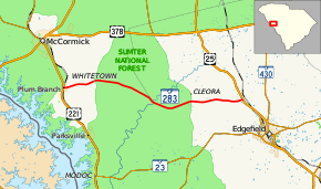
SC 283 begins at an intersection with U.S. Route 221 (US 221)/SC 28 (Main Street) in Plum Branch, within McCormick County, where the roadway continues as Collier Street. It travels to the east and nearly immediately curves to the east-northeast before leaving the city limits. The highway curves back to the east and crosses over Stevens Creek. SC 283 goes back to the northeast and enters Whitetown. Just past the intersection with Upper Mill Road the highway enters Sumter National Forest. After it starts heading to the east-southeast, it crosses over Byrd Creek. After a crossing of Wine Creek, it crosses over Turkey Creek and enters Edgefield County. Just to the east of an intersection with North Martintown Road, which is south-southwest of Cleora, the highway leaves the national forest. Farther to the east, it meets its eastern terminus, an intersection with US 25, at a point northwest of Edgefield.[2]
Major intersections
| County | Location | mi[1] | km | Destinations | Notes |
|---|---|---|---|---|---|
| McCormick | Plum Branch | 0.00 | 0.00 | ||
| Edgefield | | 17.84 | 28.71 | ||
| 1.000 mi = 1.609 km; 1.000 km = 0.621 mi | |||||
See also


References
- "Statewide Highways (shapefile)" (zip). South Carolina Department of Transportation. September 29, 2017. Retrieved December 8, 2017.
- Google (May 13, 2016). "South Carolina Highway 283" (Map). Google Maps. Google. Retrieved May 13, 2016.
External links

- SC 283 - South Carolina Hwy Index Home