U.S. Route 278 in South Carolina
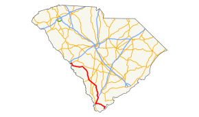
U.S. Route 278 (US 278) is an east–west United States highway that traverses through the South Carolina Lowcountry, from North Augusta to Hilton Head Island.
| ||||
|---|---|---|---|---|
 Route of US 278 in South Carolina highlighted in red | ||||
| Route information | ||||
| Auxiliary route of US 78 | ||||
| Maintained by SCDOT | ||||
| Length | 146.0 mi[1] (235.0 km) | |||
| Existed | 1965–present | |||
| Tourist routes | ||||
| Major junctions | ||||
| West end | ||||
| East end | ||||
| Location | ||||
| Counties | Aiken, Barnwell, Allendale, Hampton, Jasper, Beaufort | |||
| Highway system | ||||
| ||||

Route description
After crossing the Savannah River from Georgia, US 278 bypasses downtown North Augusta, South Carolina to the south en route to Beech Island and Johnson Crossroads. It then forms a de facto northern boundary of the Savannah River Site, crossing into the property on a few occasions. The route then continues eastward and then southward through the communities of Barnwell, Kline, Allendale, Fairfax, Hampton, Varnville, Ridgeland, and Hardeeville where it meets I-95. US 278 shares the route between Ridgeland and Hardeeville with US 17.
Upon reaching Hardeeville, the route heads eastward toward the Atlantic with large residential and commercial developments lining the spine of the road from Hardeeville through Okatie and Bluffton. The route crosses over Calibogue Sound onto Hilton Head Island. After a five-mile stretch in which the route is tolled, US 278 ends at US 278 Business on the southern portion of Hilton Head Island, just outside Sea Pines Plantation.
Cross Island Parkway
On Hilton Head Island, US 278 was previously routed along what is now US 278 Business until a new toll road, named the Cross Island Parkway, opened on January 16, 1998.[2] The 6.8-mile (10.9 km) section of roadway[2] cost $83 million to build and was funded with a combination of state funds, federal funds, state highway bonds and tolls.[3]
The controlled access toll road has only one interchange along its route at Marshland Drive. It was the first toll road built in South Carolina in modern history.[2] A majority of the road users pay their tolls using Palmetto Pass, South Carolina's system for electronic toll collection. Tolls will be removed once the bonds sold to build the road are retired.[3]
The completion of the Cross Island Parkway (a direct expressway connection from the north side to the south side of the island) has caused a great amount of commercial and residential development along the road. Before the toll road opened, it could take one hour to travel the 12-mile (19 km) route of what was then signed as US 278 (William Hilton Parkway) during peak tourism season.[2] The Cross Island Parkway greatly relieved congestion on that road when it opened.[3]
Tolls
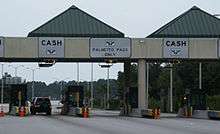
Toll rates, for 2-axle vehicles, along Cross Island Parkway are $1.25 at the toll plaza and $1.00 at the Marshland Road/Spanish Wells Road interchange. Each additional axle is $1.00 (plaza and ramps). The toll plaza has both electronic toll collection (ETC) and cash lanes, which are manned 24 hours a day; Marshland Road/Spanish Wells Road interchange accept only ETC or exact change only. Those that do not have exact change or do not pay the toll have five days to contact the Cross Island Parkway Customer Service Center to make a payment; after that time, a violation notice will be mailed. Travelers that make a mistake of taking the toll road may request a "Turn Around Pass", which gives them ten minutes to continue along the highway, turn around at the roundabout and return the pass at the toll plaza on the return trip.[4]
Only the Palmetto Pass is accepted on the Cross Island Parkway.
History
US 278 was established, in South Carolina, in 1965, traveling from Augusta, Georgia to Hilton Head Island. Crossing the Savannah River, in concurrency with US 1/US 25/US 78/SC 121, it then overlapped with SC 125 on Atomic Road, to Beech Island. Replacing SC 28 from Beech Island to Almeda, where it then replaced SC 128, going through Ridgeland, to Old House. Replacing part of SC 462, it went south into Bluffton and then east into Hilton Head Island, replacing part of SC 46.[5][6][7][8][9][10][11][12][13][14][15][16]
Throughout the 1980s, US 278 was widen to four-lane, in phases, east of SC 170, in Bluffton. In 1996-1997, US 278 was rerouted south of Ridgeland to Hardeeville, then east on new primary routing to SC 170, in Bluffton. Its former routing was replaced by SC 336 to Old House and SC 462 to SC 170.[17][18] In 1998, US 278 was rerouted onto new routing along the west side of Hilton Head Island; known as the Cross Island Parkway, the toll road provides quicker access to the far south end of the island. The old alignment, in Hilton Head Island, became US 278 Business.[19][20]
Junction list
| County | Location | mi[1] | km | Destinations | Notes |
|---|---|---|---|---|---|
| Aiken | North Augusta | 0.0 | 0.0 | Continuation from Georgia over the Savannah River | |
| 0.2 | 0.32 | 5th Street Bridge / River North Drive | |||
| 0.7 | 1.1 | Eastern end of US 25 and SC 121 concurrencies | |||
| 1.5 | 2.4 | I-520 exit 17 | |||
| Clearwater | 2.3 | 3.7 | Eastern end of US 1 and US 78 concurrencies; western end of SC 125 concurrency; southern terminus of SC 421 | ||
| Beech Island | 7.2 | 11.6 | Eastern end of SC 125 concurency | ||
| | 13.4 | 21.6 | |||
| New Ellenton | 19.6 | 31.5 | |||
| | 28.9 | 46.5 | Western terminus of SC 781 | ||
| Barnwell | | 32.7 | 52.6 | ||
| | 41.0 | 66.0 | Southern terminus of SC 37 | ||
| Barnwell | 43.3 | 69.7 | Western end of SC 64 concurrency | ||
| 43.6 | 70.2 | Western terminus of SC 70 | |||
| 43.9 | 70.7 | Eastern end of SC 64 concurrency | |||
| 45.2 | 72.7 | Western end of SC 3 concurrency | |||
| | 46.5 | 74.8 | Eastern end of SC 3 concurrency | ||
| | 46.8 | 75.3 | Northern terminus of SC 300 | ||
| Allendale | Allendale | 60.4 | 97.2 | Western end of US 301 concurrency; to USC Salkehatchie | |
| 60.7 | 97.7 | Eastern end of US 301 concurrency | |||
| Fairfax | 66.2 | 106.5 | To USC Salkehatchie | ||
| Hampton | Hampton | 75.1 | 120.9 | Western end of SC 363 concurrency | |
| 75.3 | 121.2 | Western end of US 601 concurrency | |||
| 75.9 | 122.1 | Eastern end of US 601 concurrency | |||
| 76.1 | 122.5 | Eastern end of SC 363 concurrency | |||
| Varnville | 77.9 | 125.4 | Western terminus of SC 63 | ||
| Almeda | 80.1 | 128.9 | Western terminus of SC 68 | ||
| Jasper | Grays | 91.6 | 147.4 | Southern terminus of SC 3 | |
| Gillisonville | 96.5 | 155.3 | Western end of SC 462 concurrency | ||
| | 97.3 | 156.6 | Eastern end of SC 462 concurrency | ||
| | 102.1 | 164.3 | Eastern terminus of SC 652 | ||
| Ridgeland | 106.4 | 171.2 | Western end of US 17 concurrency | ||
| 106.6 | 171.6 | ||||
| 108.9 | 175.3 | ||||
| Hardeeville | 119.2 | 191.8 | Eastern end of US 17 concurrency | ||
| 119.5 | 192.3 | I-95 exit 8 | |||
| | 124.5 | 200.4 | Argent Boulevard – Beaufort | ||
| Beaufort | | 127.4 | 205.0 | To Parris Island | |
| Bluffton | 129.1 | 207.8 | Buckwalter Parkway | ||
| 133.2 | 214.4 | Eastern terminus of SC 46 | |||
| Bluffton | 137.7 | 221.6 | Bluffton Parkway | No direct access from US 278 eastbound to Bluffton Parkway or Bluffton Parkway to US 278 westbound | |
| Hilton Head Island | 140.8 | 226.6 | To Hilton Head Airport | ||
| 143.1 | 230.3 | Marshland Road / Spanish Wells Road | Eastbound exit toll | ||
| 143.6 | 231.1 | Toll plaza | |||
| 146.0 | 235.0 | Eastern terminus; Roundabout; to Coligny Beach | |||
1.000 mi = 1.609 km; 1.000 km = 0.621 mi
| |||||
See also


- Special routes of U.S. Route 278
References
- Google (April 12, 2014). "U.S. Route 278 in South Carolina" (Map). Google Maps. Google. Retrieved April 12, 2014.
- Associated Press (January 16, 1998). "Hilton Head toll road to open". The Augusta Chronicle. Morris Communications. Archived from the original on February 17, 2013. Retrieved February 16, 2013.
- "27-in-7 Peak Performance" (PDF). South Carolina Department of Transportation. Archived from the original (PDF) on February 17, 2013.
- "Cross Island Parkway FAQ's". South Carolina Department of Transportation. Retrieved April 12, 2014.
- General Highway Map, Aiken County, South Carolina (PDF) (Map). Cartography by SCDOT. South Carolina Department of Transportation. 1956. Retrieved April 14, 2014.
- General Highway Map, Aiken County, South Carolina (PDF) (Map). Cartography by SCDOT. South Carolina Department of Transportation. 1967. Retrieved April 14, 2014.
- General Highway Map, Barnwell County, South Carolina (PDF) (Map). Cartography by SCDOT. South Carolina Department of Transportation. 1962. Retrieved April 14, 2014.
- General Highway Map, Barnwell County, South Carolina (PDF) (Map). Cartography by SCDOT. South Carolina Department of Transportation. 1967. Retrieved April 14, 2014.
- General Highway Map, Allendale County, South Carolina (PDF) (Map). Cartography by SCDOT. South Carolina Department of Transportation. 1962. Retrieved April 14, 2014.
- General Highway Map, Allendale County, South Carolina (PDF) (Map). Cartography by SCDOT. South Carolina Department of Transportation. 1967. Retrieved April 14, 2014.
- General Highway Map, Hampton County, South Carolina (PDF) (Map). Cartography by SCDOT. South Carolina Department of Transportation. 1963. Retrieved April 14, 2014.
- General Highway Map, Hampton County, South Carolina (PDF) (Map). Cartography by SCDOT. South Carolina Department of Transportation. 1967. Retrieved April 14, 2014.
- General Highway Map, Jasper County, South Carolina (PDF) (Map). Cartography by SCDOT. South Carolina Department of Transportation. 1959. Retrieved April 14, 2014.
- General Highway Map, Jasper County, South Carolina (PDF) (Map). Cartography by SCDOT. South Carolina Department of Transportation. 1966. Retrieved April 14, 2014.
- General Highway Map, Beaufort County, South Carolina (PDF) (Map). Cartography by SCDOT. South Carolina Department of Transportation. 1963. Retrieved April 14, 2014.
- General Highway Map, Beaufort County, South Carolina (PDF) (Map). Cartography by SCDOT. South Carolina Department of Transportation. 1966. Retrieved April 14, 2014.
- General Highway System, Jasper County (PDF) (Map). South Carolina Department of Transportation. June 2005. Retrieved April 14, 2014.
- General Highway System, Beaufort County (PDF) (Map). South Carolina Department of Transportation. January 2005. Retrieved April 14, 2014.
- "Report of the Special Committee on U.S. Route Numbering to the Standing Committee on Highways" (PDF). AASHTO. November 6, 1998. p. 11. Retrieved April 15, 2014.
- Hilton Head Island Urban Area, Beaufort County (PDF) (Map). South Carolina Department of Transportation. December 2011. Retrieved April 14, 2014.
External links

- U.S. Route 278 in South Carolina (Mapmikey's South Carolina Highways Page)
| Previous state: Georgia |
South Carolina | Next state: Terminus |