South Carolina Highway 230
South Carolina Highway 230 (SC 230) is a 21.2-mile-long (34.1 km) state highway in the U.S. state of South Carolina. The highway connects Sumter National Forest and North Augusta. Even though it is a north–south route on a map, it is signed as an east–west highway.
| ||||
|---|---|---|---|---|
| Martintown Road | ||||
 | ||||
| Route information | ||||
| Maintained by SCDOT | ||||
| Length | 21.16 mi[1] (34.05 km) | |||
| Major junctions | ||||
| West end | ||||
| ||||
| East end | ||||
| Location | ||||
| Counties | Edgefield, Aiken | |||
| Highway system | ||||
| ||||

Route description
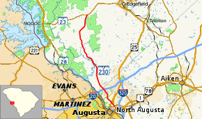
SC 230 begins at an intersection with SC 23 in the unincorporated community of West Store Crossroads, within Edgefield County. The western end of the highway travels through Sumter National Forest. It travels to the south-southwest and travels through Colliers, where it curves to the south. The highway gradually travels in more and more of a south-southeasterly direction. SC 230 crosses over Horn Creek. Just south of an intersection with Woodlawn Road and Briggs Road, the highway leaves the national forest and crosses over Anderson Branch. After curving back to the south, it crosses over Hardy Creek and Sweetwater Branch. The highway heads to the south-southeast again and travels through Poverty Hill. About 2,000 feet (610 m) later, it enters North Augusta, in which it is a major urban corridor. It crosses over Fox Creek and Pole Branch immediately before an interchange with Interstate 20 (I-20; Strom Thurmond Freeway). SC 230 has a short south section and passes underneath the North Augusta Greeneway. It then curves to the southeast before intersecting U.S. Route 25 Business (US 25 Bus.; Georgia Avenue). A few blocks later, it intersects US 25/SC 121 (Knox Avenue). Signage on eastbound SC 230 notes that it ends here, but signage farther to the southeast shows that it continues concurrent with US 25/SC 121, which take on the Martintown Road name. The three highways intersect SC 125 (Atomic Road). Here, SC 230 meets its eastern terminus.[2]
Major intersections
| County | Location | mi[1] | km | Destinations | Notes |
|---|---|---|---|---|---|
| Edgefield | West Store Crossroads | 0.00 | 0.00 | Western terminus | |
| Aiken | North Augusta | 16.99– 17.38 | 27.34– 27.97 | I-20 exit 1 | |
| 20.19 | 32.49 | ||||
| 20.59– 20.73 | 33.14– 33.36 | Western end of US 25/SC 121 concurrency; eastbound signage notes the highway ends here | |||
| 21.16 | 34.05 | Eastern terminus; eastern end of US 25/SC 121 concurrency | |||
1.000 mi = 1.609 km; 1.000 km = 0.621 mi
| |||||
See also


References
- "Statewide Highways (shapefile)" (zip). South Carolina Department of Transportation. September 29, 2017. Retrieved December 8, 2017.
- Google (May 11, 2016). "South Carolina Highway 230" (Map). Google Maps. Google. Retrieved May 11, 2016.
External links
