South Carolina Highway 430
South Carolina Highway 430 (SC 430) is an 11.7-mile-long (18.8 km) state highway in the west central part of the U.S. state of South Carolina. The highway travels in a south-north orientation from just northeast of Edgefield northwest and then due north to a point on the edge of Sumter National Forest, all within Edgefield County.
| ||||
|---|---|---|---|---|
 | ||||
| Route information | ||||
| Maintained by SCDOT | ||||
| Length | 11.74 mi[1] (18.89 km) | |||
| Major junctions | ||||
| South end | ||||
| North end | ||||
| Location | ||||
| Counties | Edgefield | |||
| Highway system | ||||
| ||||

Route description
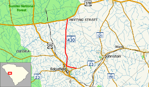
SC 430 begins at an intersection with SC 23 just northeast of Edgefield. The route heads northwest, cutting across the northeast part of the city. It then intersects U.S. Route 25 (US 25) in the northern part of the city. SC 430 then heads due north until it meets its northern terminus, at an intersection with US 378 on the southeastern edge of Sumter National Forest, in a rural part of the county.[2]
SC 430 is not part of the National Highway System, a system of roadways important to the nation's economy, defense, and mobility.[3]
History
Major intersections
The entire route is in Edgefield County.
| Location | mi[1] | km | Destinations | Notes | |
|---|---|---|---|---|---|
| | 0.00 | 0.00 | |||
| Edgefield | 2.14 | 3.44 | |||
| Sumter National Forest | 11.74 | 18.89 | |||
| 1.000 mi = 1.609 km; 1.000 km = 0.621 mi | |||||
See also


References
- South Carolina Department of Transportation: Statewide Highways 2012. Specifics: . Files: .
- Google (February 2, 2013). "Route of SC 430" (Map). Google Maps. Google. Retrieved February 2, 2013.
- "National Highway System: South Carolina" (PDF). United States Department of Transportation. October 1, 2012. Retrieved July 1, 2013.
External links
