Sumoor
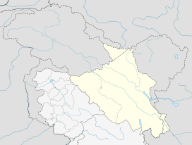
Sumoor is a village in the Leh district of Ladakh, India.[1][2]
Sumoor | |
|---|---|
Village | |
 Sumoor Location in Ladakh, India  Sumoor Sumoor (India) | |
| Coordinates: 34.5973014°N 77.8584365°E | |
| Country | India |
| Union Territory | Ladakh |
| District | Leh |
| Tehsil | Nubra |
| Elevation | 6,033 m (19,793 ft) |
| Population (2011) | |
| • Total | 711 |
| Time zone | UTC+5:30 (IST) |
| 2011 census code | 932 |
Demographics
According to the 2011 census of India, Sumoor has 164 households. The effective literacy rate (i.e. the literacy rate of population excluding children aged 6 and below) is 66.14%.[3]
| Total | Male | Female | |
|---|---|---|---|
| Population | 711 | 385 | 326 |
| Children aged below 6 years | 76 | 36 | 40 |
| Scheduled caste | 0 | 0 | 0 |
| Scheduled tribe | 678 | 358 | 320 |
| Literates | 420 | 260 | 160 |
| Workers (all) | 251 | 185 | 66 |
| Main workers (total) | 120 | 83 | 37 |
| Main workers: Cultivators | 2 | 2 | 0 |
| Main workers: Agricultural labourers | 2 | 1 | 1 |
| Main workers: Household industry workers | 5 | 5 | 0 |
| Main workers: Other | 111 | 75 | 36 |
| Marginal workers (total) | 131 | 102 | 29 |
| Marginal workers: Cultivators | 98 | 81 | 17 |
| Marginal workers: Agricultural labourers | 16 | 6 | 10 |
| Marginal workers: Household industry workers | 1 | 1 | 0 |
| Marginal workers: Others | 16 | 14 | 2 |
| Non-workers | 460 | 200 | 260 |
gollark: It actually could be quite useful, as a convenient way to have fast-to-update single-file image things.
gollark: Hey, maybe I could actually do this with FUSE.
gollark: Idea: filesystem which is literally just SQLite.
gollark: > petition to call wireless mice "hamsters"YESDO THIS
gollark: I also have an unused £12 mouse.
References
- Leh tehsils.
- "Blockwise Village Amenity Directory" (PDF). Ladakh Autonomous Hill Development Council. Retrieved 23 July 2015.
- "Leh district census". 2011 Census of India. Directorate of Census Operations. Retrieved 23 July 2015.
This article is issued from Wikipedia. The text is licensed under Creative Commons - Attribution - Sharealike. Additional terms may apply for the media files.