Diskit
Diskit is a village and headquarter of the Nubra tehsil and the Nubra subdivision in the Leh district of Ladakh in India.[1][2] The Diskit Monastery is located in this village.
Diskit | |
|---|---|
Village | |
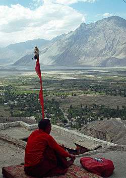 A monk meditates on the terrace of Diskit Monastery, with the Nubra Valley and the Diskit village seen in the background | |
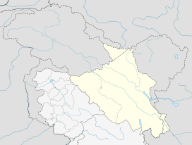 Diskit Location in Ladakh, India  Diskit Diskit (India) | |
| Coordinates: 34.551210°N 77.548478°E | |
| Country | India |
| Union Territory | Ladakh |
| District | Leh |
| Tehsil | Nubra |
| Population (2011) | |
| • Total | 1,760 |
| Time zone | UTC+5:30 (IST) |
| Census code | 929 |
Demographics
According to the 2011 census of India, Diskit had 344 households. The effective literacy rate (i.e. the literacy rate of population excluding children aged 6 and below) is 76.57%.[3]
| Total | Male | Female | |
|---|---|---|---|
| Population | 1760 | 924 | 836 |
| Children aged below 6 years | 185 | 102 | 83 |
| Scheduled caste | 3 | 3 | 0 |
| Scheduled tribe | 1519 | 737 | 782 |
| Literates | 1206 | 707 | 499 |
| Workers (all) | 927 | 534 | 393 |
| Main workers (total) | 889 | 509 | 380 |
| Main workers: Cultivators | 378 | 129 | 249 |
| Main workers: Agricultural labourers | 2 | 0 | 2 |
| Main workers: Household industry workers | 0 | 0 | 0 |
| Main workers: Other | 509 | 380 | 129 |
| Marginal workers (total) | 38 | 25 | 13 |
| Marginal workers: Cultivators | 16 | 8 | 8 |
| Marginal workers: Agricultural labourers | 1 | 0 | 1 |
| Marginal workers: Household industry workers | 0 | 0 | 0 |
| Marginal workers: Others | 21 | 17 | 4 |
| Non-workers | 833 | 390 | 443 |
Tourism
Diskit is one of the major towns in the Nubra region of Ladakh. It is a popular destination for tourists and is situated around 118 km from Leh and 7 km from the town of Hunder. Situated on the banks of the Shyok River, Diskit has many homestay and guest house options that are open throughout the year. The main market is a small place with a few tiny restaurants.[4]
See Also
- KENDRIYA VIDYALAYA NUBRA
- Sub Division Hospital, Diskit, Nubra
- J&K Bank, Nubra
- Lamdon Model Senior Secondary School
- Govt. Degree College Nubra
- PWD Office Nubra
gollark: Me? Comments? Ha.
gollark: It's in `src/lib/yafss.lua` in the repo.
gollark: There are a bunch of "fake" files mapped into the sandbox.
gollark: The filesystem shown to user code doesn't have to actually match the real one.
gollark: No, I mean I can meddle with the filesystem mappings.
References
- "Blockwise Village Amenity Directory" (PDF). Ladakh Autonomous Hill Development Council. Archived from the original (PDF) on 9 September 2016. Retrieved 23 July 2015.
- Leh tehsils.
- "Leh district census". 2011 Census of India. Directorate of Census Operations. Retrieved 23 July 2015.
- "Crazy Peaks".
| Wikimedia Commons has media related to Diskit. |
| History |
| ||||||||
|---|---|---|---|---|---|---|---|---|---|
| Administration | |||||||||
| Geography |
| ||||||||
| Settlements and locations | |||||||||
| Districts | |||||||||
| Dam |
| ||||||||
| Monasteries | |||||||||
| Transport | |||||||||
| See also | |||||||||
This article is issued from Wikipedia. The text is licensed under Creative Commons - Attribution - Sharealike. Additional terms may apply for the media files.