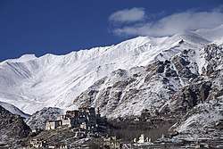
Likir
Likir is a village and headquarter of eponymous Subdivision in the Leh district of Ladakh, India.[2][3] It is located in the Likir tehsil, in the Ladakh region. Khalatse is a nearby trekking place.[4]
Likir | |
|---|---|
Village | |
 | |
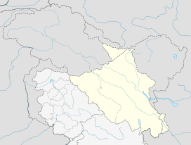 Likir Location in Ladakh, India  Likir Likir (India) | |
| Coordinates: 34.2903203°N 77.2132106°E | |
| Country | India |
| District | Leh |
| Tehsil | Likir[1] |
| Elevation | 3,651 m (11,978 ft) |
| Population (2011) | |
| • Total | 1,058 |
| Time zone | UTC+5:30 (IST) |
| 2011 census code | 848 |
It is famous for the nearby Klu-kkhyil (meaning "water spirits") gompa (Buddhist monastery). The Likir Monastery was first built in the 11th century and was rebuilt in the 18th century, and currently has a 25-foot-tall (7.6 m) gold-covered Buddha statue. It is occupied by monks of the Gelukpa order. It is located 52 km from Leh.
Demographics
According to the 2011 census of India, Likir has 218 households. The effective literacy rate (i.e. the literacy rate of population excluding children aged 6 and below) is 72.93%.[5]
| Total | Male | Female | |
|---|---|---|---|
| Population | 1058 | 573 | 485 |
| Children aged below 6 years | 105 | 57 | 48 |
| Scheduled caste | 0 | 0 | 0 |
| Scheduled tribe | 1056 | 572 | 484 |
| Literates | 695 | 432 | 263 |
| Workers (all) | 299 | 211 | 88 |
| Main workers (total) | 255 | 194 | 61 |
| Main workers: Cultivators | 141 | 122 | 19 |
| Main workers: Agricultural labourers | 20 | 16 | 4 |
| Main workers: Household industry workers | 3 | 3 | 0 |
| Main workers: Other | 91 | 53 | 38 |
| Marginal workers (total) | 44 | 17 | 27 |
| Marginal workers: Cultivators | 13 | 2 | 11 |
| Marginal workers: Agricultural labourers | 1 | 0 | 1 |
| Marginal workers: Household industry workers | 1 | 1 | 0 |
| Marginal workers: Others | 29 | 14 | 15 |
| Non-workers | 759 | 362 | 397 |
gollark: That doesn't address anything else I said.
gollark: Ah yes, indirectly then. Swap that for "in useful quantities" or "without expending tons of time/resources" if you like.
gollark: I didn't mention "money".
gollark: What?
gollark: (Sidenote: interestingly, apparently the development of farming actually led to significantly *worse* life for people for quite a long time, because it allowed much more population per land area, causing people to end up at a subsistence level and quite malnourished and stuff)
References
| Wikimedia Commons has media related to Likir. |
- https://leh.nic.in/about-district/administrative-setup/village/
- "Blockwise Village Amenity Directory" (PDF). Ladakh Autonomous Hill Development Council. Retrieved 23 July 2015.
- Leh tehsils.
- "Leh district census". 2011 Census of India. Directorate of Census Operations. Retrieved 23 July 2015.
| History |
| ||||||||
|---|---|---|---|---|---|---|---|---|---|
| Administration | |||||||||
| Geography |
| ||||||||
| Settlements and locations | |||||||||
| Districts | |||||||||
| Dam |
| ||||||||
| Monasteries | |||||||||
| Transport | |||||||||
| See also | |||||||||
This article is issued from Wikipedia. The text is licensed under Creative Commons - Attribution - Sharealike. Additional terms may apply for the media files.