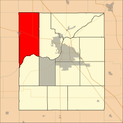
Shelby Township, Tippecanoe County, Indiana
Shelby Township is one of thirteen townships in Tippecanoe County, Indiana, United States. As of the 2010 census, its population was 2,352 and it contained 920 housing units.[2]
Shelby Township | |
|---|---|
 Location in Tippecanoe County | |
| Coordinates: 40°28′51″N 87°03′01″W | |
| Country | United States |
| State | Indiana |
| County | Tippecanoe |
| Government | |
| • Type | Indiana township |
| Area | |
| • Total | 54.17 sq mi (140.3 km2) |
| • Land | 53.65 sq mi (139.0 km2) |
| • Water | 0.51 sq mi (1.3 km2) 0.94% |
| Elevation | 699 ft (213 m) |
| Population (2010) | |
| • Total | 2,352 |
| • Density | 43.8/sq mi (16.9/km2) |
| Time zone | UTC-5 (Eastern (EST)) |
| • Summer (DST) | UTC-4 (EDT) |
| ZIP codes | 47906, 47970 |
| Area code(s) | 765 |
| GNIS feature ID | 453847 |
Geography
According to the 2010 census, the township has a total area of 54.17 square miles (140.3 km2), of which 53.65 square miles (139.0 km2) (or 99.04%) is land and 0.51 square miles (1.3 km2) (or 0.94%) is water.[2]
Cities, towns, villages
- Otterbein (east half)
Unincorporated communities
(This list is based on USGS data and may include former settlements.)
Extinct towns
Adjacent townships
- Round Grove Township, White County (north)
- Wabash Township (east)
- Wayne Township (south)
- Davis Township, Fountain County (southwest)
- Medina Township, Warren County (southwest)
- Warren Township, Warren County (southwest)
- Bolivar Township, Benton County (west)
- Pine Township, Benton County (northwest)
Cemeteries
The township contains these four cemeteries: Asbury, Shambaugh, Spencer, and Montmorenci.
Major highways


Airports and landing strips
- Sutton Airport
School districts
- Benton Community School Corporation
- Tippecanoe School Corporation
Political districts
- Indiana's 4th congressional district
- State House District 26
- State Senate District 22
Education
gollark: Anyway, the e-ink ones (or at least mine) have an accursed non-Android Linuxy thing with a UI entirely done with web technology for some reason.
gollark: I think it's entirely the same except they have a different set of preinstalled apps to AOSP/Googlized Android, and Amazon services instead.
gollark: It's basically Android.
gollark: * e-paper, e-ink is a brand name.
gollark: This is the e-ink version.
References
- United States Census Bureau 2007 TIGER/Line Shapefiles
- United States Board on Geographic Names (GNIS)
- United States National Atlas
- "US Board on Geographic Names". United States Geological Survey. October 25, 2007. Retrieved 2017-05-09.
- "Population, Housing Units, Area, and Density: 2010 - County -- County Subdivision and Place -- 2010 Census Summary File 1". United States Census. Retrieved 2013-05-10.
This article is issued from Wikipedia. The text is licensed under Creative Commons - Attribution - Sharealike. Additional terms may apply for the media files.