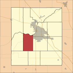
Union Township, Tippecanoe County, Indiana
Union Township is one of thirteen townships in Tippecanoe County, Indiana, United States. As of the 2010 census, its population was 1,610 and it contained 675 housing units.[2]
Union Township | |
|---|---|
 Location in Tippecanoe County | |
| Coordinates: 40°20′40″N 86°57′49″W | |
| Country | United States |
| State | Indiana |
| County | Tippecanoe |
| Government | |
| • Type | Indiana township |
| Area | |
| • Total | 27.35 sq mi (70.8 km2) |
| • Land | 27.12 sq mi (70.2 km2) |
| • Water | 0.23 sq mi (0.6 km2) 0.84% |
| Elevation | 679 ft (207 m) |
| Population (2010) | |
| • Total | 1,610 |
| • Density | 59.4/sq mi (22.9/km2) |
| Time zone | UTC-5 (Eastern (EST)) |
| • Summer (DST) | UTC-4 (EDT) |
| ZIP codes | 47909 |
| Area code(s) | 765 |
| GNIS feature ID | 453935 |
Geography
According to the 2010 census, the township has a total area of 27.35 square miles (70.8 km2), of which 27.12 square miles (70.2 km2) (or 99.16%) is land and 0.23 square miles (0.60 km2) (or 0.84%) is water.[2] The township and the town of Shadeland share the same borders.
Adjacent townships
- Wabash Township (north)
- Fairfield Township (northeast)
- Wea Township (east)
- Randolph Township (southeast)
- Jackson Township (southwest)
- Wayne Township (west)
Cemeteries
The township contains these three cemeteries: Durkee, Farmers Institute and Hickory Grove.
Major highways
School districts
- Tippecanoe School Corporation
Political districts
- Indiana's 4th congressional district
- State House District 26
- State Senate District 22
gollark: Also, did you know? ALL are to contribute to minoteaur æ.
gollark: minoteaur™ continues to be not *technically* abandoned.
gollark: What are your unfinished πρωjεκτς like?
gollark: The language breakdown is boring due to github apioforms.
gollark: I move my particularly unfinished projects to my random stuff git repo nowadays.
References
- United States Census Bureau 2007 TIGER/Line Shapefiles
- United States Board on Geographic Names (GNIS)
- United States National Atlas
- "US Board on Geographic Names". United States Geological Survey. October 25, 2007. Retrieved 2017-05-09.
- "Population, Housing Units, Area, and Density: 2010 - County -- County Subdivision and Place -- 2010 Census Summary File 1". United States Census. Archived from the original on 2020-02-12. Retrieved 2013-05-10.
This article is issued from Wikipedia. The text is licensed under Creative Commons - Attribution - Sharealike. Additional terms may apply for the media files.