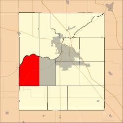
Wayne Township, Tippecanoe County, Indiana
Wayne Township is one of thirteen townships in Tippecanoe County, Indiana, United States. As of the 2010 census, its population was 1,580 and it contained 623 housing units.[2]
Wayne Township | |
|---|---|
 Location in Tippecanoe County | |
| Coordinates: 40°21′15″N 87°02′27″W | |
| Country | United States |
| State | Indiana |
| County | Tippecanoe |
| Government | |
| • Type | Indiana township |
| Area | |
| • Total | 34.63 sq mi (89.7 km2) |
| • Land | 34.28 sq mi (88.8 km2) |
| • Water | 0.35 sq mi (0.9 km2) 1.01% |
| Elevation | 617 ft (188 m) |
| Population (2010) | |
| • Total | 1,580 |
| • Density | 46.1/sq mi (17.8/km2) |
| Time zone | UTC-5 (Eastern (EST)) |
| • Summer (DST) | UTC-4 (EDT) |
| ZIP codes | 47906, 47909, 47918, 47992 |
| Area code(s) | 765 |
| GNIS feature ID | 454041 |
Geography

The Wabash River forms the township's northern border. Photo looks toward the extinct communities of Ouiatenon and Granville.
According to the 2010 census, the township has a total area of 34.63 square miles (89.7 km2), of which 34.28 square miles (88.8 km2) (or 98.99%) is land and 0.35 square miles (0.91 km2) (or 1.01%) is water.[2]
Unincorporated communities
- Glenhall at 40.3542030°N 87.0408434°W
- Westpoint at 40.3450364°N 87.0430655°W
(This list is based on USGS data and may include former settlements.)
Adjacent townships
- Shelby Township (north)
- Wabash Township (northeast)
- Union Township (east)
- Jackson Township (south)
- Davis Township, Fountain County (southwest)
- Warren Township, Warren County (west)
Cemeteries
The township contains these three cemeteries: Granville, Marks and Sherry.
Major highways
School districts
- Tippecanoe School Corporation
Political districts
- Indiana's 4th congressional district
- State House District 41
- State Senate District 22
gollark: I get 5 different deprecation warnings but technically no crash.
gollark: At last I may be making progress. Or possibly unprogress.
gollark: I should make ABR illegally harvest all their messages.
gollark: <@!854350605702660106>'s habit of deleting things after people reply is irritating.
gollark: Which reminds me, I could and should make PotatOS Bootable Edition None Are Safe™.
References
- "US Board on Geographic Names". United States Geological Survey. October 25, 2007. Retrieved 2017-05-09.
- "Population, Housing Units, Area, and Density: 2010 - County -- County Subdivision and Place -- 2010 Census Summary File 1". United States Census. Retrieved 2013-05-10.
This article is issued from Wikipedia. The text is licensed under Creative Commons - Attribution - Sharealike. Additional terms may apply for the media files.