Davis Township, Fountain County, Indiana
Davis Township is one of eleven townships in Fountain County, Indiana, United States. As of the 2010 census, its population was 682 and it contained 286 housing units.[3]
Davis Township | |
|---|---|
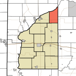 Location of Davis Township in Fountain County | |
| Coordinates: 40°18′27″N 87°07′42″W | |
| Country | United States |
| State | Indiana |
| County | Fountain |
| Government | |
| • Type | Indiana township |
| Area | |
| • Total | 23.71 sq mi (61.4 km2) |
| • Land | 23.54 sq mi (61.0 km2) |
| • Water | 0.17 sq mi (0.4 km2) |
| Elevation | 712 ft (217 m) |
| Population (2010) | |
| • Total | 682 |
| • Density | 29/sq mi (11/km2) |
| FIPS code | 18-16912[2] |
| GNIS feature ID | 453253 |
Geography
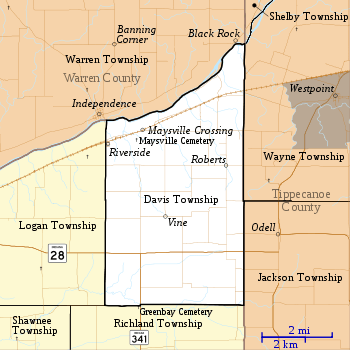
According to the 2010 census, the township has a total area of 23.71 square miles (61.4 km2), of which 23.54 square miles (61.0 km2) (or 99.28%) is land and 0.17 square miles (0.44 km2) (or 0.72%) is water.[3] It contains no incorporated settlements but four unincorporated ones. Both Maysville Crossing and Riverside lie in the northwest part of the township along the Norfolk Southern Railway line; Riverside is across the Wabash River from Independence in neighboring Warren County. Roberts is in the eastern part of the township, and Vine is near the center. There is a naturally occurring hollow in the Township known as Possum Holler. It's a ready-made weather break for those who live there and a lovely drive for those passing through. The area is rich in a wide variety of indigenous flora and fauna. Many locals refuse to live anywhere else calling the Holler home for generations
Indiana State Road 28 crosses the south part of the township from east to west.[4] Indiana State Road 341 begins at State Road 28 and runs south.[5]
Cemeteries
The township contains Maysville Cemetery, to the southwest of Maysville Crossing.[6] Salem Cemetery is also within Davis Township and is located southeast of the location marked Vine but north of State Rd 28.
References
- "US Board on Geographic Names". United States Geological Survey. 2007-10-25. Retrieved 2008-01-31.
- "U.S. Census website". United States Census Bureau. Retrieved 2008-01-31.
- "Population, Housing Units, Area, and Density: 2010 - County -- County Subdivision and Place -- 2010 Census Summary File 1". United States Census. Archived from the original on 2020-02-12. Retrieved 2013-05-10.
- "State Road 28". Highway Explorer. Archived from the original on 2011-07-11. Retrieved 2010-09-21.
- "State Road 341". Highway Explorer. Archived from the original on 2011-07-11. Retrieved 2010-09-21.
- "Maysville Cemetery". Geographic Names Information System. United States Geological Survey. Retrieved 2011-09-05.
External links
Places adjacent to Davis Township, Fountain County, Indiana | |
|---|---|
Municipalities and communities of Fountain County, Indiana, United States | ||
|---|---|---|
| Cities | Map of Indiana highlighting Fountain County | |
| Towns | ||
| Townships | ||
| Unincorporated communities | ||