Glen Hall, Indiana
Glen Hall is a small unincorporated community in Wayne Township, Tippecanoe County, in the U.S. state of Indiana.[2]
Glen Hall, Indiana | |
|---|---|
 Looking north into Glen Hall along County Road 700W | |
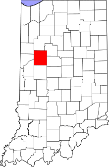 Tippecanoe County's location in Indiana | |
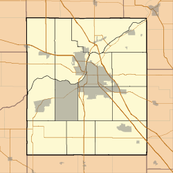 Glen Hall Location in Tippecanoe County | |
| Coordinates: 40°21′15″N 87°2′27″W | |
| Country | United States |
| State | Indiana |
| County | Tippecanoe |
| Township | Wayne |
| Elevation | 617 ft (188 m) |
| Time zone | UTC-5 (Eastern (EST)) |
| • Summer (DST) | UTC-4 (EDT) |
| ZIP code | 47992 |
| Area code(s) | 765 |
| GNIS feature ID | 435116 |
The site is often considered part of the adjoining town of West Point.
History
A post office was established at Glen Hall in 1866, and remained in operation until it was discontinued in 1904.[3]
Geography
Glen Hall is located at 40°21'15" North, 87°02'27" West (40.354203, -87.040843), less than half a mile north of West Point. It is in Wayne Township and has an elevation of approximately 625 feet.
gollark: (because it's bad, and won't do that automatically)
gollark: (technically it also has some code to force it to respond to an instant-lose/instant-win situation)
gollark: It is funny that people keep losing to a fairly trivial piece of code which just decides how good a move is by playing 100 *entirely random games* starting from it and seeing how many it wins.
gollark: Okay, I am now decreasing my estimate of your programming competence.
gollark: I don't know if there's a general strategy. The main thing to exploit is that the AI can't really respond to two threats at once.
References
- "US Board on Geographic Names". United States Geological Survey. October 25, 2007. Retrieved 2016-07-25.
- "Glen Hall, Indiana". Geographic Names Information System. United States Geological Survey. Retrieved August 4, 2017.
- "Tippecanoe County". Jim Forte Postal History. Retrieved July 25, 2016.
Municipalities and communities of Tippecanoe County, Indiana, United States | ||
|---|---|---|
| Cities | Map of Indiana highlighting Tippecanoe County | |
| Towns | ||
| Townships | ||
| CDPs | ||
| Other unincorporated communities |
| |
| Ghost towns | ||
| Footnotes | ‡This populated place also has portions in an adjacent county or counties | |
This article is issued from Wikipedia. The text is licensed under Creative Commons - Attribution - Sharealike. Additional terms may apply for the media files.