Sealdah–Ranaghat line
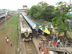
The Sealdah–Ranaghat line connects Sealdah and Ranaghat in the Indian state of West Bengal. It includes Kolkata Railway Station, the Calcutta chord link to Dankuni on the Howrah-Bardhaman Chord, the link to Bandel on the Howrah-Bardhaman Main Line, and the Kalyani Simanta link. This line has change-over facilities to Kolkata Metro and Kolkata Circular Railway. It is part of the Kolkata Suburban Railway system and is under the jurisdiction of Eastern Railway.
 Sealdah–Ranaghat line | |||||||||||||||||||||||||||||||||||||||||||||||||||||||||||||||||||||||||||||||||||||||||||||||||||||||||||||||||||||||||||||||||||||||||||||||||||||||||||||||||||||||||||||||||||||||||||||||||||||||||||||||||||||||||||||||||||||||||||||||||||||||||||||||||||||||||||||||||||||||||||||||||||||||||||||||||||||||||||||||||||||||||||||||||||||||||||||||||||||||||||||||||||||||
|---|---|---|---|---|---|---|---|---|---|---|---|---|---|---|---|---|---|---|---|---|---|---|---|---|---|---|---|---|---|---|---|---|---|---|---|---|---|---|---|---|---|---|---|---|---|---|---|---|---|---|---|---|---|---|---|---|---|---|---|---|---|---|---|---|---|---|---|---|---|---|---|---|---|---|---|---|---|---|---|---|---|---|---|---|---|---|---|---|---|---|---|---|---|---|---|---|---|---|---|---|---|---|---|---|---|---|---|---|---|---|---|---|---|---|---|---|---|---|---|---|---|---|---|---|---|---|---|---|---|---|---|---|---|---|---|---|---|---|---|---|---|---|---|---|---|---|---|---|---|---|---|---|---|---|---|---|---|---|---|---|---|---|---|---|---|---|---|---|---|---|---|---|---|---|---|---|---|---|---|---|---|---|---|---|---|---|---|---|---|---|---|---|---|---|---|---|---|---|---|---|---|---|---|---|---|---|---|---|---|---|---|---|---|---|---|---|---|---|---|---|---|---|---|---|---|---|---|---|---|---|---|---|---|---|---|---|---|---|---|---|---|---|---|---|---|---|---|---|---|---|---|---|---|---|---|---|---|---|---|---|---|---|---|---|---|---|---|---|---|---|---|---|---|---|---|---|---|---|---|---|---|---|---|---|---|---|---|---|---|---|---|---|---|---|---|---|---|---|---|---|---|---|---|---|---|---|---|---|---|---|---|---|---|---|---|---|---|---|---|---|---|---|---|---|---|---|---|---|---|---|---|---|---|---|---|---|---|---|---|---|---|---|---|---|---|---|---|---|---|---|---|---|---|---|---|---|---|---|---|---|---|---|---|---|---|---|---|---|---|---|---|---|---|---|---|
| Overview | |||||||||||||||||||||||||||||||||||||||||||||||||||||||||||||||||||||||||||||||||||||||||||||||||||||||||||||||||||||||||||||||||||||||||||||||||||||||||||||||||||||||||||||||||||||||||||||||||||||||||||||||||||||||||||||||||||||||||||||||||||||||||||||||||||||||||||||||||||||||||||||||||||||||||||||||||||||||||||||||||||||||||||||||||||||||||||||||||||||||||||||||||||||||
| Type | Commuter rail | ||||||||||||||||||||||||||||||||||||||||||||||||||||||||||||||||||||||||||||||||||||||||||||||||||||||||||||||||||||||||||||||||||||||||||||||||||||||||||||||||||||||||||||||||||||||||||||||||||||||||||||||||||||||||||||||||||||||||||||||||||||||||||||||||||||||||||||||||||||||||||||||||||||||||||||||||||||||||||||||||||||||||||||||||||||||||||||||||||||||||||||||||||||||
| System | Kolkata Suburban Railway | ||||||||||||||||||||||||||||||||||||||||||||||||||||||||||||||||||||||||||||||||||||||||||||||||||||||||||||||||||||||||||||||||||||||||||||||||||||||||||||||||||||||||||||||||||||||||||||||||||||||||||||||||||||||||||||||||||||||||||||||||||||||||||||||||||||||||||||||||||||||||||||||||||||||||||||||||||||||||||||||||||||||||||||||||||||||||||||||||||||||||||||||||||||||
| Status | Operational | ||||||||||||||||||||||||||||||||||||||||||||||||||||||||||||||||||||||||||||||||||||||||||||||||||||||||||||||||||||||||||||||||||||||||||||||||||||||||||||||||||||||||||||||||||||||||||||||||||||||||||||||||||||||||||||||||||||||||||||||||||||||||||||||||||||||||||||||||||||||||||||||||||||||||||||||||||||||||||||||||||||||||||||||||||||||||||||||||||||||||||||||||||||||
| Locale | West Bengal | ||||||||||||||||||||||||||||||||||||||||||||||||||||||||||||||||||||||||||||||||||||||||||||||||||||||||||||||||||||||||||||||||||||||||||||||||||||||||||||||||||||||||||||||||||||||||||||||||||||||||||||||||||||||||||||||||||||||||||||||||||||||||||||||||||||||||||||||||||||||||||||||||||||||||||||||||||||||||||||||||||||||||||||||||||||||||||||||||||||||||||||||||||||||
| Termini | Sealdah Ranaghat | ||||||||||||||||||||||||||||||||||||||||||||||||||||||||||||||||||||||||||||||||||||||||||||||||||||||||||||||||||||||||||||||||||||||||||||||||||||||||||||||||||||||||||||||||||||||||||||||||||||||||||||||||||||||||||||||||||||||||||||||||||||||||||||||||||||||||||||||||||||||||||||||||||||||||||||||||||||||||||||||||||||||||||||||||||||||||||||||||||||||||||||||||||||||
| Stations | 25 | ||||||||||||||||||||||||||||||||||||||||||||||||||||||||||||||||||||||||||||||||||||||||||||||||||||||||||||||||||||||||||||||||||||||||||||||||||||||||||||||||||||||||||||||||||||||||||||||||||||||||||||||||||||||||||||||||||||||||||||||||||||||||||||||||||||||||||||||||||||||||||||||||||||||||||||||||||||||||||||||||||||||||||||||||||||||||||||||||||||||||||||||||||||||
| Daily ridership | 1 million | ||||||||||||||||||||||||||||||||||||||||||||||||||||||||||||||||||||||||||||||||||||||||||||||||||||||||||||||||||||||||||||||||||||||||||||||||||||||||||||||||||||||||||||||||||||||||||||||||||||||||||||||||||||||||||||||||||||||||||||||||||||||||||||||||||||||||||||||||||||||||||||||||||||||||||||||||||||||||||||||||||||||||||||||||||||||||||||||||||||||||||||||||||||||
| Website | Eastern Railway | ||||||||||||||||||||||||||||||||||||||||||||||||||||||||||||||||||||||||||||||||||||||||||||||||||||||||||||||||||||||||||||||||||||||||||||||||||||||||||||||||||||||||||||||||||||||||||||||||||||||||||||||||||||||||||||||||||||||||||||||||||||||||||||||||||||||||||||||||||||||||||||||||||||||||||||||||||||||||||||||||||||||||||||||||||||||||||||||||||||||||||||||||||||||
| Operation | |||||||||||||||||||||||||||||||||||||||||||||||||||||||||||||||||||||||||||||||||||||||||||||||||||||||||||||||||||||||||||||||||||||||||||||||||||||||||||||||||||||||||||||||||||||||||||||||||||||||||||||||||||||||||||||||||||||||||||||||||||||||||||||||||||||||||||||||||||||||||||||||||||||||||||||||||||||||||||||||||||||||||||||||||||||||||||||||||||||||||||||||||||||||
| Opened | 1862 | ||||||||||||||||||||||||||||||||||||||||||||||||||||||||||||||||||||||||||||||||||||||||||||||||||||||||||||||||||||||||||||||||||||||||||||||||||||||||||||||||||||||||||||||||||||||||||||||||||||||||||||||||||||||||||||||||||||||||||||||||||||||||||||||||||||||||||||||||||||||||||||||||||||||||||||||||||||||||||||||||||||||||||||||||||||||||||||||||||||||||||||||||||||||
| Owner | Indian Railway | ||||||||||||||||||||||||||||||||||||||||||||||||||||||||||||||||||||||||||||||||||||||||||||||||||||||||||||||||||||||||||||||||||||||||||||||||||||||||||||||||||||||||||||||||||||||||||||||||||||||||||||||||||||||||||||||||||||||||||||||||||||||||||||||||||||||||||||||||||||||||||||||||||||||||||||||||||||||||||||||||||||||||||||||||||||||||||||||||||||||||||||||||||||||
| Operator(s) | Eastern Railway | ||||||||||||||||||||||||||||||||||||||||||||||||||||||||||||||||||||||||||||||||||||||||||||||||||||||||||||||||||||||||||||||||||||||||||||||||||||||||||||||||||||||||||||||||||||||||||||||||||||||||||||||||||||||||||||||||||||||||||||||||||||||||||||||||||||||||||||||||||||||||||||||||||||||||||||||||||||||||||||||||||||||||||||||||||||||||||||||||||||||||||||||||||||||
| Character | At grade | ||||||||||||||||||||||||||||||||||||||||||||||||||||||||||||||||||||||||||||||||||||||||||||||||||||||||||||||||||||||||||||||||||||||||||||||||||||||||||||||||||||||||||||||||||||||||||||||||||||||||||||||||||||||||||||||||||||||||||||||||||||||||||||||||||||||||||||||||||||||||||||||||||||||||||||||||||||||||||||||||||||||||||||||||||||||||||||||||||||||||||||||||||||||
| Depot(s) | Sealdah Ranaghat | ||||||||||||||||||||||||||||||||||||||||||||||||||||||||||||||||||||||||||||||||||||||||||||||||||||||||||||||||||||||||||||||||||||||||||||||||||||||||||||||||||||||||||||||||||||||||||||||||||||||||||||||||||||||||||||||||||||||||||||||||||||||||||||||||||||||||||||||||||||||||||||||||||||||||||||||||||||||||||||||||||||||||||||||||||||||||||||||||||||||||||||||||||||||
| Technical | |||||||||||||||||||||||||||||||||||||||||||||||||||||||||||||||||||||||||||||||||||||||||||||||||||||||||||||||||||||||||||||||||||||||||||||||||||||||||||||||||||||||||||||||||||||||||||||||||||||||||||||||||||||||||||||||||||||||||||||||||||||||||||||||||||||||||||||||||||||||||||||||||||||||||||||||||||||||||||||||||||||||||||||||||||||||||||||||||||||||||||||||||||||||
| Line length | 74 km (46 mi) | ||||||||||||||||||||||||||||||||||||||||||||||||||||||||||||||||||||||||||||||||||||||||||||||||||||||||||||||||||||||||||||||||||||||||||||||||||||||||||||||||||||||||||||||||||||||||||||||||||||||||||||||||||||||||||||||||||||||||||||||||||||||||||||||||||||||||||||||||||||||||||||||||||||||||||||||||||||||||||||||||||||||||||||||||||||||||||||||||||||||||||||||||||||||
| Number of tracks | 4 up to Naihati Junction; 2 then onward | ||||||||||||||||||||||||||||||||||||||||||||||||||||||||||||||||||||||||||||||||||||||||||||||||||||||||||||||||||||||||||||||||||||||||||||||||||||||||||||||||||||||||||||||||||||||||||||||||||||||||||||||||||||||||||||||||||||||||||||||||||||||||||||||||||||||||||||||||||||||||||||||||||||||||||||||||||||||||||||||||||||||||||||||||||||||||||||||||||||||||||||||||||||||
| Track gauge | 1,676 mm (5 ft 6 in) Broad gauge | ||||||||||||||||||||||||||||||||||||||||||||||||||||||||||||||||||||||||||||||||||||||||||||||||||||||||||||||||||||||||||||||||||||||||||||||||||||||||||||||||||||||||||||||||||||||||||||||||||||||||||||||||||||||||||||||||||||||||||||||||||||||||||||||||||||||||||||||||||||||||||||||||||||||||||||||||||||||||||||||||||||||||||||||||||||||||||||||||||||||||||||||||||||||
| Electrification | 25 kV overhead line | ||||||||||||||||||||||||||||||||||||||||||||||||||||||||||||||||||||||||||||||||||||||||||||||||||||||||||||||||||||||||||||||||||||||||||||||||||||||||||||||||||||||||||||||||||||||||||||||||||||||||||||||||||||||||||||||||||||||||||||||||||||||||||||||||||||||||||||||||||||||||||||||||||||||||||||||||||||||||||||||||||||||||||||||||||||||||||||||||||||||||||||||||||||||
| Operating speed | up to 100 km/h (62 mph) | ||||||||||||||||||||||||||||||||||||||||||||||||||||||||||||||||||||||||||||||||||||||||||||||||||||||||||||||||||||||||||||||||||||||||||||||||||||||||||||||||||||||||||||||||||||||||||||||||||||||||||||||||||||||||||||||||||||||||||||||||||||||||||||||||||||||||||||||||||||||||||||||||||||||||||||||||||||||||||||||||||||||||||||||||||||||||||||||||||||||||||||||||||||||
| |||||||||||||||||||||||||||||||||||||||||||||||||||||||||||||||||||||||||||||||||||||||||||||||||||||||||||||||||||||||||||||||||||||||||||||||||||||||||||||||||||||||||||||||||||||||||||||||||||||||||||||||||||||||||||||||||||||||||||||||||||||||||||||||||||||||||||||||||||||||||||||||||||||||||||||||||||||||||||||||||||||||||||||||||||||||||||||||||||||||||||||||||||||||
History
The main line of the Eastern Bengal Railway from Sealdah to Ranaghat, was opened in 1862 and extended to Kushtia, now in Bangladesh, within two months. The Calcutta terminus of the Railway was opened the same year in a tin-roofed shed at Sealdah.[1] The line was extended to Goalundo Ghat in 1864, although it was opened in 1871.[2]


The Eastern Bengal Railway, which operated east of the Hooghly, was linked with the East Indian Railway, which operated west of the river, when Jubilee Bridge, linking Bandel and Naihati was opened in 1887. The Calcutta Chord Railway constructed the line from Dum Dum to Dankuni over the Willingdon Bridge in 1932. The bridge was later renamed Vivekananda Setu.
The original station at Sealdah, designed by Walter Glanville, was built in 1869. It was then called the Calcutta Station. It was renamed Sealdah Station only after the partition of India in 1947.
Looking back
There is a vivid description of the railway system of Nadia district, in which Ranaghat lies, about a century ago, in the District Gazetteer. The district then included areas now part of Bangladesh.
"The district is now (1909) very well served with railways. About 170 miles of the Eastern Bengal State Railway, all broad gauge, lie within its borders. The main line from Calcutta to Siliguri passes through the district, roughly from south to north; the distance from Kanchrapara on the southern boundary to Damukdia on the Padma is about 92 miles, and this section has 21 stations. The Lal Gola branch takes off from Ranaghat junction; it passes in a north-westerly direction; the portion within the district is about 48 miles in length, and there are 8 stations upon it. This branch traverses the Kalantar, which is the tract that is most liable to famine in the district and generally contains the lowest stock of food grains. In the 1896-97 famine the supply of food suddenly gave out in this tract, and, in the absence of the railway, which had not then been constructed, the greatest difficulty was experienced in importing enough grain to prevent deaths from starvation. If another famine should unfortunately occur, this line will save the District Officer much of the anxiety which his predecessors had to bear. The central branch of the Eastern Bengal State Railway also takes off from Ranaghat junction; only about nine miles of it (with two stations) lies within the boundaries of the district; it passes in an easterly direction through the Ranaghat subdivision into the Bangaon subdivision of the Jessore district. The Goalundo branch takes off from Poradah."[3]
Tracks
The Sealdah-Ranaghat Line presently has two tracks. It is expected that the proposal for a third line will be part of the budget proposals in 2012.[4]
The Sealdah - Dumdum - Naihati - Kalyani - Ranaghat – Krishnanagar track is classified as a C-class track, which is not a speed classification but one used for suburban sections of metropolitan areas.[5]
Electrification
The Sealdah-Ranaghat Line was electrified in 1963. Dum Dum-Dankuni, Dum Dum-Chitpore Yard, and Bandel-Naihati sections were electrified in 1965.[2][6]
Passengers
Line-wise or route-wise passenger data is not available, but Sealdah Station handles 1.5 million passengers arriving or departing in 704 trains daily (including EMU locals) and a good proportion of that uses this line as it is the main line out of that station.[7]
Trains
Among the important trains from Sealdah using this track are: Maitree Express to Dhaka, Rajdhani Express to New Delhi, Duronto Express to New Delhi, Annanya Express to Udaipur, Akal Takht Express to Amritsar, Darjeeling Mail to Haldibari, Bhagirathi Express to Lalgola, Gour Express to Balurghat, and Uttar Banga Express to New Cooch Behar.
The Sealdah-Puri Duronto Express which was introduced in February 2012 is the first train from Sealdah to South Eastern Railway bypassing Howrah Station. It runs over a part of this track.[8]
Stations
The railway stations on this route are:
| S No | Railway Station |
|---|---|
| 1 | Sealdah |
| 2 | Bidhannagar Road |
| 3 | Dum Dum Junction |
| 4 | Belgharia |
| 5 | Agarpara |
| 6 | Sodpur |
| 7 | Khardaha |
| 8 | Titagarh |
| 9 | Barrackpore |
| 10 | Palta |
| 11 | Ichhapur |
| 12 | Shyamnagar |
| 13 | Jagaddal |
| 14 | Kankinara |
| 15 | Naihati Junction |
| 16 | Halisahar |
| 17 | Kanchrapara Workshop Gate |
| 18 | Kanchrapara |
| 19 | Kalyani |
| 20 | Madanpur |
| 21 | Simurali |
| 22 | Palpara |
| 23 | Chakdaha |
| 24 | Payradanga |
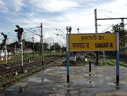
| 25 | Ranaghat Junction |
References
- R.P. Saxena. "Indian Railway History timeline". IRFCA. Archived from the original on 14 July 2012. Retrieved 10 February 2012.
- "The Chronology of Railway development in Eastern Indian". railindia. Archived from the original on 2 August 2012. Retrieved 10 February 2012.
- J.H.E.Garrett. "Nadia, Bengal District Gazetteers (1910)". IRFCA. Retrieved 10 February 2012.
- "Mamata flags off railway project at Ranaghat". The Statesman, 8 January 2011. Retrieved 10 February 2012.
- "Permanent Way – Track Classification". IRFCA. Retrieved 10 February 2012.
- "History of Electrification". IRFCA. Retrieved 10 February 2012.
- "Few Toilets at Howrah, Sealdah". The Times of India, 28 November 2001. Retrieved 10 February 2012.
- "Puri Duronto to merge railway zones". The Times of India. Retrieved 13 February 2012.