North Jersey
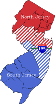
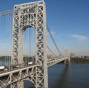
North Jersey comprises the northern portions of the U.S. state of New Jersey between the upper Delaware River and the Atlantic Ocean. The designation of northern New Jersey with a distinct toponym is a colloquial one rather than an administrative one, reflecting not only geographical but also perceived cultural differences from the southern part of the state, with no official definition.[1][2] The region is characterized by a high level of economic output, emanating from economic engines including Paramus in Bergen County, which has become the top retail ZIP code (07652) in the United States, with the municipality generating over US$6 billion in annual retail sales;[3] Jersey City, whose financial district has been nicknamed Wall Street West;[4] Newark Liberty International Airport; and the Newark-Elizabeth Seaport. Bergen County is New Jersey's most populous county and serves as the western terminus for the George Washington Bridge, the world's busiest motor vehicle bridge, connecting Fort Lee, New Jersey to Upper Manhattan in New York City.[5]
Geography
Geologically, the north is in the Piedmont Province, the Highlands Province, and the Ridge and Valley Province. Depending on definitions, some is counted as being in the Atlantic coastal plain. This region has a Humid Continental Climate (Dfb) by Köppen.
Two-portion approaches
A broad definition includes all points in New Jersey north of I-295 in the western part of the state and all points north of I-195 in the eastern part of the state. Another definition uses the 1958 telephone area code 201 (not the modern area), and all its additions. Some people, especially residents of the northern tier of counties, use a narrower definition, counting only that area north of the mouth of the Raritan River.
Three-portion approaches
The state is also sometimes described as having North Jersey and South Jersey separated from each other by Central Jersey.[6]
Generally in this approach, North Jersey is defined as anything north of Exit 10 on the New Jersey Turnpike.
Further subdivision
In 2008 the New Jersey State Department of Tourism divided the state into six tourist regions, of which the Gateway Region and the Skylands Region are in North Jersey.[7]
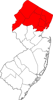
North Jersey counties
- See also: #Demographics, below.
The following counties are considered North Jersey.
History
North Jersey was the site of some of the earliest European settlements in what would become the United States of America. Its colonial history started after Henry Hudson sailed through Newark Bay in 1609. Although Hudson was British, he worked for the Netherlands, so he claimed the land for the Dutch as part of the provincial colony of New Netherland,[8] with original settlements were centered on Bergen (today's Hudson County). In 1664 the region became part of the Province of New Jersey.
During the American Revolutionary War, New Jersey was a strategic location between New York City, and the Continental Congress in Philadelphia. Important materials necessary to the war effort were produced in North Jersey. The Continental Army made its home here during the war, and history from this period can be found in nearly every village and town in North Jersey. Battle fields, camps, skirmish sites, and headquarters can be found near Morristown and north in the Preakness Valley. In the northwestern part of the state, iron mines and foundries supplied raw material for guns and ammunition.
The Industrial Revolution in America started by the founding of the North Jersey town of Paterson. Today, the United States and the world enjoy the fruit born of seeds planted in North Jersey during the Industrial Revolution. Alexander Hamilton, Secretary for the Treasury and President of the Bank of New York during the end of the eighteenth century, selected the Great Falls area (also known as the Passaic Falls) for an ambitious experiment. He promoted the natural power of the Great Falls as an excellent location for textile mills and other manufacture.
Paterson attracted skilled craftsmen and engineers from Europe to run the mills and produced a large concentration of creative and able people. During the mid nineteenth century, the engines and materials to tame a continent were made here. Thomas Edison installed one of the first hydroelectric power plants in the world using the Great Falls as an energy source. This power plant still provides electricity today.
In West Orange, Edison created the first technical research and development facility with his "invention factory". Electric light, improved motion pictures, and sound recording, were among the hundreds of inventions produced here.[9]
Demographics
The seven counties that are included in North Jersey have a total population of 3,492,590 as of the 2000 U.S. Census. The demographics of all of the counties are 66.8% White, 18.5% Hispanic or Latino, 15.4% African American, 6.6% Asian, 0.2% Native American, and 0.1% Pacific Islander.
Population
| 2017 Rank | Municipality | County | Population in
2017 |
Population in
2010 |
Municipal
Type |
|---|---|---|---|---|---|
| 1 | Newark | Essex | 285,154 | 277,140 | City |
| 2 | Jersey City | Hudson | 270,753 | 247,597 | City |
| 3 | Paterson | Passaic | 148,678 | 146,199 | City |
| 4 | Clifton | Passaic | 86,607 | 84,136 | City |
| 5 | Passaic | Passaic | 71,247 | 69,781 | City |
| 6 | Union City | Hudson | 70,387 | 66,455 | City |
| 7 | Bayonne | Hudson | 67,186 | 63,024 | City |
| 8 | East Orange | Essex | 65,378 | 64,270 | City |
| 9 | North Bergen | Hudson | 63,659 | 60,773 | Township |
| 10 | Hoboken | Hudson | 55,131 | 50,005 | City |
| 11 | Wayne | Passaic | 55,072 | 54,717 | Township |
| 12 | Irvington | Essex | 54,865 | 53,926 | Township |
| 13 | West New York | Hudson | 54,227 | 49,708 | Town |
| 14 | Parsippany-Troy Hills | Morris | 53,201 | 53,238 | Township |
| 15 | Bloomfield | Essex | 50,970 | 47,315 | Township |
| 16 | West Orange | Essex | 48,425 | 46,207 | Township |
| 17 | Hackensack | Bergen | 45,248 | 43,010 | City |
| 18 | Kearny | Hudson | 42,670 | 40,648 | Town |
| 19 | Teaneck | Bergen | 41,311 | 39,776 | Township |
| 20 | Montclair | Essex | 39,227 | 37,669 | Township |
| 21 | Fort Lee | Bergen | 37,907 | 35,345 | Borough |
| 22 | Belleville | Essex | 36,498 | 35,926 | Township |
| 23 | Fair Lawn | Bergen | 33,710 | 32,457 | Borough |
| 24 | Garfield | Bergen | 32,393 | 30,487 | City |
| 25 | City of Orange | Essex | 30,813 | 30,134 | Township |
| 26 | Livingston | Essex | 30,142 | 29,366 | Township |
| Rank | County | Population | County Seat | Area |
|---|---|---|---|---|
| 1 | Bergen | 936,692 | Hackensack | 234 sq mi
(606 km2) |
| 2 | Essex | 799,767 | Newark | 126 sq mi
(326 km2) |
| 3 | Hudson | 676,061 | Jersey City | 47 sq mi
(122 km2) |
| 4 | Passaic | 503,310 | Paterson | 185 sq mi
(479 km2) |
| 5 | Morris | 494,228 | Morristown | 469 sq mi
(1,215 km2) |
| 6 | Sussex | 140,799 | Newton | 521 sq mi
(1,349 km2) |
| 7 | Warren | 105,779 | Belvidere | 358 sq mi
(927 km2) |
Professional sports fans
Sports allegiances are often divided between the northern and southern portions of the state.[2] The 2009 World Series divided the people of New Jersey, because South Jersey residents generally root for the Philadelphia Phillies, while North Jersey residents usually root for the New York Yankees or the New York Mets. A similar trend exists for most other major sports, with North Jersey residents supporting the Brooklyn Nets or the New York Knicks in basketball, the New Jersey Devils, or the New York Rangers in hockey, the New York Red Bulls or New York City FC in soccer, and the New York Giants or the New York Jets in football.
Dialect
Notable North Jerseyans
- People from Bergen County
- People from Essex County
- People from Hudson County
- People from Morris County
- People from Passaic County
- People from Sussex County
- People from Warren County
See also
References and footnotes
- "Drawing the line: Talking with the blogger behind "Where is the Line Between North & South Jersey?"". nj.com.
- Mikle, Jean (March 31, 2008). "An invisible boundary divides N.J." Home News Tribune. Retrieved January 12, 2010.("Of course, part of the problem with understanding New Jersey's enduring regional tension is that few residents can agree on where the northern half of the state end and the southern half begins.")
- Allison Pries (March 10, 2019). "Inside the N.J. town where retail spending beats Hollywood and tourism rivals Disney". New Jersey On-Line LLC. Retrieved May 5, 2019.
The former farming community already sees more retail sales than any other zip code in the country...More than $6 billion in retail sales happen in Paramus each year.
- A Vision for Smart Transit in Jersey City Archived 2016-12-26 at the Wayback Machine, United States Department of Transportation, February 4, 2016. Accessed May 5, 2019. "Development along the Hudson River waterfront led to the development of the 'Wall Street West' financial district, one of the largest centers of banking and finance in the nation."
- Accessed May 5, 2019.
- Stirling, Stephen (April 24, 2015). "Here are the North, Central and South Jersey borders as determined by you (INTERACTIVE)". NJ.com. Retrieved December 16, 2015.
For one, NJ.com readers overwhelmingly agreed that Central Jersey does, in fact, exist. More than 50,000 of the votes received went toward categorizing Central Jersey towns, far outweighing those received for North and South Jersey.
- "New Jersey Travel Destinations (map)". 2008. Archived from the original on September 18, 2008. Retrieved June 21, 2015.
- "A short history of New Jersey".
- History of Northern New Jersey from Rt23.com'
- Wirstiuk, Laryssa. "Neighborhood Spotlight: Journal Square" Archived 2018-06-30 at the Wayback Machine, Jersey City Independent, April 21, 2014. Accessed May 5, 2019. "India Square, for example, is situated between John F. Kennedy Boulevard and Tonnelle Avenue on Newark Ave., and is home to the highest concentration of Asian Indians in the Western Hemisphere."
- "List of municipalities in New Jersey", Wikipedia, 2019-09-20, retrieved 2019-09-27
- "List of counties in New Jersey", Wikipedia, 2019-09-20, retrieved 2019-09-27
