Mohanpur, Deoghar
Mohanpur is a community development block that forms an administrative division in Deoghar district, Jharkhand state, India. It is located 14 km from Deoghar, the district headquarters.
Mohanpur | |
|---|---|
Community development block | |
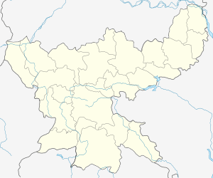
 Mohanpur Location in Jharkhand, India  Mohanpur Mohanpur (India) | |
| Coordinates: 24°29′41″N 86°46′49″E | |
| Country | |
| State | Jharkhand |
| District | Deoghar |
| Government | |
| • Type | Community development block |
| Elevation | 268 m (879 ft) |
| Population (2011) | |
| • Total | 175,845 |
| Languages | |
| • Official | Hindi, Santali |
| Literacy (2011) | |
| • Total literates | 83,926 (58.66%) |
| Time zone | UTC+5:30 (IST) |
| Telephone/STD code | 06432 |
| Vehicle registration | JH 15 |
| Lok Sabha constituency | Godda |
| Vidhan Sabha constituency | Deoghar |
| Website | deoghar |
| CD Block | |
Geography
Mohanpur, the eponymous CD Block headquarters, is located at 24°29′41″N 86°46′49″E.[1]
Gram panchayats
Gram panchayats in Mohanpur CD Block are: Baghmari Kitakhawra, Balthar, Bank, Banka, Bara, Bhikna, Bichgarha, Chakarama, Dahijore, Ghongha, Ghutabara Ashana, Harkatta, Jamunia, Jhalar, Jharkhandi, Katwan, Kajuria (Sarasani), Malhara, Medinidih, Morne, Nayachitkath, Postwari, Raghunathpur, Radhia, Suardehi, Tarabad, Thadiyara, and Tumbabel.[2]
Demographics
As of the 2011 Census of India, Mohanpur CD Block had a total population of 175,845, all of which were rural. There were 91,477 (52 %) males and 84,368 (48 %) females. Scheduled Castes numbered 23,976 and Scheduled Tribes numbered 18,039. Population below 6 years was 32,766.[3]
Mohanpur is a village with a population of 177 as per 2011 census.[3]
Literacy
As of the 2011 census, the total number of literates in Mohanpur CD Block was 83,926 (58.66 % of the population over 6 years) out of which 53,175 (63 %) were males and 30,751 (37 %) were females.[3]
As of the 2011 census, literacy in Deoghar district was 64.85.[4] Literacy in Jharkhand (for population over 7 years) was 66.41% in 2011.[5] Literacy in India in 2011 was 74.04%.[6]
Transportation
The Jasidih–Dumka–Rampurhat railway line is fully operational from June 2015. The Jasidih-Dumka sector was operational from 2011. There is a railway station at Mohanpur named Mohanpur railway station.[7][8]
References
- "Petrol Pump (Chopa More)". Jharkhand. Wikimapia. Retrieved 6 January 2016.
- "List of Gram Panchayats in Deoghar District" (PDF). 2015 update. Deoghar district administration. Retrieved 6 January 2016.
- "2011 Census C.D. Block Wise Primary Census Abstract Data(PCA)". Jharkhand – District-wise CD Blocks. Registrar General and Census Commissioner, India. Retrieved 6 January 2016.
- "District Census 2011". Population Census 2011. Retrieved 6 January 2016.
- "Jharkhand Profile" (PDF). Census Info India 2011 – Final population totals. Census Commissioner, Government of India. Retrieved 6 January 2016.
- "Literacy in India". Census 2011. Census population 2015 data. Retrieved 6 January 2016.
- "New rail line for Dumka, Santhal Pargana linked to Bengal, waits for train to Bihar". The Telegraph, 5 June 2015. Retrieved 6 January 2016.
- "Dumka-Rampuhat train service flagged off". The Times of India, 5 June 2015. Retrieved 6 January 2016.