Winnipeg Route 135
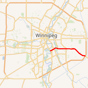
Route 135, also known as Fermor Avenue, is a city route in Winnipeg, Manitoba. It runs from Dunkirk Drive to the Perimeter Highway, through the suburbs of St. Vital and St. Boniface.
| ||||
|---|---|---|---|---|
| Fermor Avenue | ||||

Route 135 highlighted in red | ||||
| Route information | ||||
| Maintained by City of Winnipeg | ||||
| Length | 12.4 km[1] (7.7 mi) | |||
| Existed | 1966–present | |||
| Component highways | PTH 1 (Trans-Canada Highway) | |||
| Major junctions | ||||
| West end | Route 62 (Dunkirk Dr) | |||
| East end | PTH 100 (TCH) west / PTH 101 north (Perimeter Hwy) PTH 1 (TCH) east | |||
| Highway system | ||||
| Manitoba provincial highways Winnipeg City Routes
| ||||
The route begins as a principal arterial road, passing through residential, commercial, and industrial areas before becoming an expressway with service roads east of Lagimodière Boulevard (Highway 59). The section between St. Anne's Road and the Perimeter Highway forms part of the Trans-Canada Highway (Highway 1) route through the city.
Major intersections
From west to east:
| Municipality | Location | km[1] | mi | Exit | Destinations | Notes |
|---|---|---|---|---|---|---|
| Winnipeg | St. Vital | 0.0 | 0.0 | No southbound exit | ||
| 0.7 | 0.43 | |||||
| 1.3 | 0.81 | West end of PTH 1 concurrency | ||||
| St. Boniface | 2.6 | 1.6 | ||||
| 3.3 | 2.1 | Autumwood Drive / Lakewood Boulevard | ||||
| 4.2 | 2.6 | Westmount Drive / Beaverhill Boulevard | ||||
| 5.4 | 3.4 | |||||
| R.M. Springfield | 7.9 | 4.9 | — | Plessis Road north | Interchange | |
| 12.4 | 7.7 | 348 | Interchange; signed as exits 348A (west) and 348B (north); PTH 100 / PTH 101 exit 1; east end of PTH 1 concurrency | |||
1.000 mi = 1.609 km; 1.000 km = 0.621 mi
| ||||||
gollark: The time of giannises was very confusing.
gollark: I figure YouTube is bound to fail eventually since it's trying to handle too many conflicting demands from various sides and not handling any that well. But for now it sort of works.
gollark: You could probably use non-youtube video hosting, but it would be annoying and hard to monetize.
gollark: I would assume making the images out of them takes some work, unless there's a convenient script for that.
gollark: Do you just spend ages manually compiling these big collages of comemnts?
See also
References
- Google (August 11, 2017). "Route 135 in Winnipeg, MB" (Map). Google Maps. Google. Retrieved August 11, 2017.
This article is issued from Wikipedia. The text is licensed under Creative Commons - Attribution - Sharealike. Additional terms may apply for the media files.
