Rural Municipality of Reynolds
The Rural Municipality of Reynolds is located in southeastern Manitoba, Canada. It is the largest rural municipality by area in Manitoba, at 3,573.3 km² (1,379.66 sq mi). Most of Manitoba's Sandilands Provincial Forest and Agassiz Provincial Forest are located here, as are parts of Whiteshell Provincial Forest and Whiteshell Provincial Park.
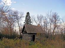
Log Cabin near Medika
Communities
- Culver
- East Braintree
- Hadashville
- Hazel
- Hocter
- Indigo
- Larkhall
gollark: How would *that* happen?
gollark: Have you not seen a spacebar? It's just a solid plastic cuboid with GTech™ nanocircuitry inside to detect nearby objects.
gollark: Spacebars are symmetrical, so you're wrong.
gollark: https://64.media.tumblr.com/ae4898ec3c1d7a7534f7266445bad049/7ff84d4defaea8bd-f5/s500x750/4d33ab6126f2a3d5f6030e0dbc73b5644c12bf0f.jpg
gollark: Please submit it to the GTech™ idea containment authority.
References
- the Rural Municipality of Reynolds website
- Manitoba Historical Society - Rural Municipality of Reynolds
- Map of Reynolds R.M. at Statcan
Places adjacent to Rural Municipality of Reynolds | |
|---|---|
Division No. 1, Manitoba (Eastern Manitoba) | ||
|---|---|---|
| Towns | 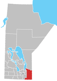 | |
| Local government districts | ||
| Rural municipalities | ||
| First Nations | ||
| Indian reserves |
| |
| Unorganized areas | ||
| Unincorporated communities | ||
This article is issued from Wikipedia. The text is licensed under Creative Commons - Attribution - Sharealike. Additional terms may apply for the media files.