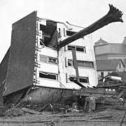
Johnstown Flood National Memorial
Johnstown Flood National Memorial commemorates the more than 2,200 people who died in the Johnstown Flood on May 31, 1889, caused by a break in the South Fork Dam, an earthen structure. The memorial is located at 733 Lake Road near South Fork, Pennsylvania,[1] about 10 miles (16 km) northeast of Johnstown. The memorial preserves the remains of the dam and portions of the former Lake Conemaugh bed, along with the farm of Elias Unger and the clubhouse of the South Fork Fishing and Hunting Club which owned the dam and reservoir. The United States Congress authorized the national memorial on August 31, 1964.[1]
| Johnstown Flood National Memorial | |
|---|---|
.jpg) Dam abutment and Elias Unger's farm | |
 Location in the United States  Location in Pennsylvania | |
| Location | Croyle Township / Adams Township, Cambria County, Pennsylvania, USA |
| Nearest city | Johnstown, Pennsylvania |
| Coordinates | 40°20′44″N 78°46′43″W |
| Area | 164.12 acres (66.42 ha)[1] |
| Established | August 31, 1964[1] |
| Visitors | 111,987 (in 2005) |
| Governing body | National Park Service |
| Website | Johnstown Flood National Memorial |
Gallery
gollark: Probably the most effective way to store power, though, is as... nuclear fuel, which you put into the reactor when more power is needed (automatically).
gollark: Well, what is your "modlist"?
gollark: Technically, you would be storing *energy*.
gollark: What do you need to "store" this "power" for?
gollark: Yep!
See also
References
- "The National Parks: Index 2005 - 2007" (PDF). National Park Service, US Department of the Interior. p. 75. Archived from the original (PDF) on 2006-10-10. Retrieved 2009-05-07.
- The National Parks: Index 2001–2003. Washington: U.S. Department of the Interior.
External links
| Wikimedia Commons has media related to Johnstown Flood National Memorial. |
This article is issued from Wikipedia. The text is licensed under Creative Commons - Attribution - Sharealike. Additional terms may apply for the media files.


