National Register of Historic Places listings in Jefferson County, Pennsylvania
This is a list of the National Register of Historic Places listings in Jefferson County, Pennsylvania.
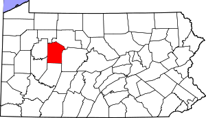
Location of Jefferson County in Pennsylvania
This is intended to be a complete list of the properties and districts on the National Register of Historic Places in Jefferson County, Pennsylvania, United States. The locations of National Register properties and districts for which the latitude and longitude coordinates are included below, may be seen in a map.[1]
There are 15 properties and districts listed on the National Register in the county.
- This National Park Service list is complete through NPS recent listings posted August 14, 2020.[2]
Current listings
| [3] | Name on the Register | Image | Date listed[4] | Location | City or town | Description |
|---|---|---|---|---|---|---|
| 1 | Brockwayville Passenger Depot, Buffalo, Rochester and Pittsburgh Railroad | 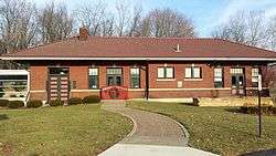 Brockwayville Passenger Depot, Buffalo, Rochester and Pittsburgh Railroad |
May 29, 2003 (#03000489) |
Alexander Street at Fourth Avenue 41°15′04″N 78°47′36″W |
Brockway | |
| 2 | Brookville Historic District | 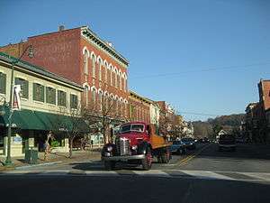 Brookville Historic District |
June 7, 1984 (#84003409) |
Roughly bounded by railroad tracks, Franklin Avenue, Church and Main Streets 41°09′37″N 79°04′58″W |
Brookville | |
| 3 | Brookville Presbyterian Church and Manse | 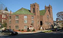 Brookville Presbyterian Church and Manse |
November 26, 1982 (#82001538) |
White and Main Streets 41°09′40″N 79°05′00″W |
Brookville | |
| 4 | Clear Creek State Park Day Use District | Clear Creek State Park Day Use District |
February 11, 1987 (#87000018) |
4 miles (6.4 km) north of Sigel on Pennsylvania Route 949 41°19′23″N 79°04′46″W |
Heath Township | |
| 5 | Clear Creek State Park Family Cabin District | 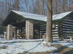 Clear Creek State Park Family Cabin District |
February 12, 1987 (#87000106) |
4 miles (6.4 km) north of Sigel on Pennsylvania Route 949 41°20′00″N 79°06′07″W |
Heath Township | |
| 6 | Gray-Taylor House | 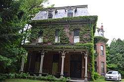 Gray-Taylor House |
August 3, 1979 (#79002244) |
9 Walnut Street 41°09′46″N 79°05′01″W |
Brookville | |
| 7 | Joseph E. Hall House | 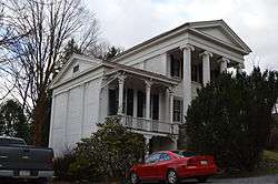 Joseph E. Hall House |
December 13, 1978 (#78002408) |
419 West Main 41°09′39″N 79°05′04″W |
Brookville | |
| 8 | Herpel Brothers Foundry and Machine Shop | 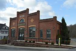 Herpel Brothers Foundry and Machine Shop |
August 4, 2004 (#04000806) |
45 West Main Street 41°05′59″N 78°53′36″W |
Reynoldsville | |
| 9 | Jefferson Theater | Jefferson Theater |
May 9, 1985 (#85001001) |
230 North Findley Street 40°56′41″N 78°58′17″W |
Punxsutawney | |
| 10 | Joseph Knapp Hotel and Store | April 26, 2018 (#100002371) |
15285 Pennsylvania Route 28 41°08′03″N 79°09′10″W |
Clover Township | ||
| 11 | T. M. Kurtz House | .jpg) T. M. Kurtz House |
July 28, 1988 (#88001158) |
312 West Mahoning Street 40°56′35″N 78°58′22″W |
Punxsutawney | |
| 12 | Christian Miller House | .jpg) Christian Miller House |
January 9, 1995 (#94001565) |
233 West Mahoning Street 40°56′34″N 78°58′28″W |
Punxsutawney | |
| 13 | Redferd Segers House | 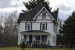 Redferd Segers House |
May 5, 2000 (#00000447) |
U.S. Route 219, opposite Township Route 1025 41°14′49″N 78°46′02″W |
Snyder Township | |
| 14 | Phillip Taylor House | 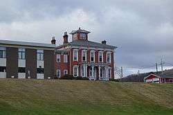 Phillip Taylor House |
July 22, 1982 (#82003790) |
Euclid Avenue 41°09′04″N 79°04′49″W |
Brookville | |
| 15 | United States Post Office-Punxsutawney | .jpg) United States Post Office-Punxsutawney |
November 22, 2000 (#00001428) |
201 North Findley Street 40°56′41″N 78°58′20″W |
Punxsutawney |
gollark: It's actually really simple.
gollark: Maybe tomorrow.
gollark: It only replicates in one direction and causes much lag.
gollark: It's very easy with the recursive blueprints mod.
gollark: I built a factorio self-replicator!
See also
| Wikimedia Commons has media related to National Register of Historic Places in Jefferson County, Pennsylvania. |
References
- The latitude and longitude information provided in this table was derived originally from the National Register Information System, which has been found to be fairly accurate for about 99% of listings. Some locations in this table may have been corrected to current GPS standards.
- "National Register of Historic Places: Weekly List Actions". National Park Service, United States Department of the Interior. Retrieved on August 14, 2020.
- Numbers represent an ordering by significant words. Various colorings, defined here, differentiate National Historic Landmarks and historic districts from other NRHP buildings, structures, sites or objects.
- The eight-digit number below each date is the number assigned to each location in the National Register Information System database, which can be viewed by clicking the number.
Municipalities and communities of Jefferson County, Pennsylvania, United States | ||
|---|---|---|
| Boroughs | | |
| Townships | ||
| CDP | ||
| Unincorporated communities |
| |
| Footnotes | ‡This populated place also has portions in an adjacent county or counties | |
| Topics | 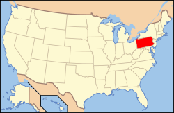 | |
|---|---|---|
| Lists by county |
| |
| Lists by city |
| |
| Other lists | ||
| ||
This article is issued from Wikipedia. The text is licensed under Creative Commons - Attribution - Sharealike. Additional terms may apply for the media files.