National Register of Historic Places listings in Schuylkill County, Pennsylvania
This is a list of the National Register of Historic Places listings in Schuylkill County, Pennsylvania.
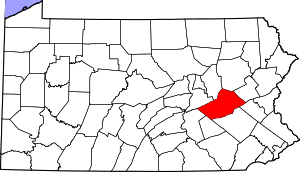
Location of Schuylkill County in Pennsylvania
This is intended to be a complete list of the properties and districts on the National Register of Historic Places in Schuylkill County, Pennsylvania, United States. The locations of National Register properties and districts for which the latitude and longitude coordinates are included below, may be seen in a map.[1]
There are 18 properties and districts listed on the National Register in the county. Two sites are further designated as National Historic Landmarks and another is designated as a National Historic Site.
- This National Park Service list is complete through NPS recent listings posted August 14, 2020.[2]
Current listings
| [3] | Name on the Register | Image | Date listed[4] | Location | City or town | Description |
|---|---|---|---|---|---|---|
| 1 | Anthracite Bank Building | 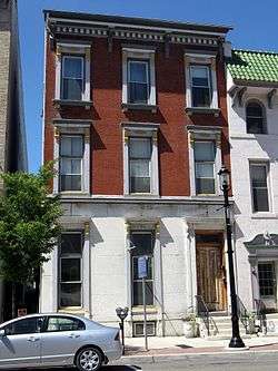 Anthracite Bank Building |
September 13, 1978 (#78002469) |
133 West Broad Street 40°47′50″N 75°58′23″W |
Tamaqua | |
| 2 | Cloud Home | 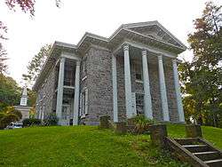 Cloud Home |
May 22, 1978 (#78002465) |
351 South 2nd Street 40°40′49″N 76°11′42″W |
Pottsville | |
| 3 | New Ringgold Gristmill | .jpg) New Ringgold Gristmill |
December 18, 1978 (#78002464) |
Legislative Route 53062 40°41′25″N 76°00′24″W |
East Brunswick Township | |
| 4 | Nutting Hall | .jpg) Nutting Hall |
July 23, 1980 (#80003627) |
205 South Tulpehocken Street 40°32′48″N 76°23′05″W |
Pine Grove | |
| 5 | John O'Hara House | 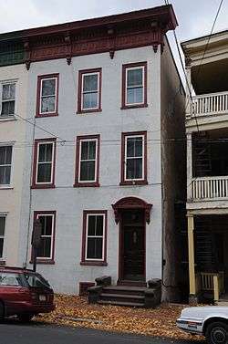 John O'Hara House |
May 22, 1978 (#78002466) |
606 Mahantongo Street 40°40′58″N 76°11′59″W |
Pottsville | |
| 6 | George Ormrod House | 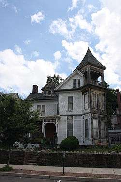 George Ormrod House |
June 14, 1977 (#77001193) |
218 West Broad Street 40°47′48″N 75°58′25″W |
Tamaqua | |
| 7 | Burd Patterson House | 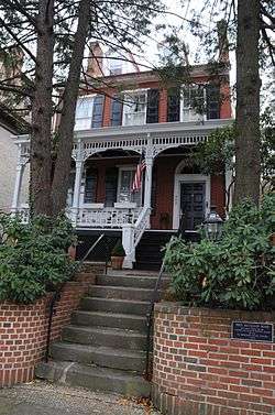 Burd Patterson House |
April 27, 1995 (#95000515) |
803 Mahantongo Street 40°40′53″N 76°12′02″W |
Pottsville | |
| 8 | Pine Grove Historic District | 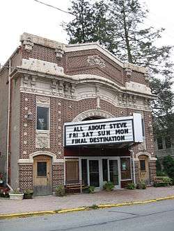 Pine Grove Historic District |
December 31, 1987 (#87002210) |
South Tulpehocken and Mill Streets, and Swatara Creek 40°32′47″N 76°23′04″W |
Pine Grove | |
| 9 | Pottsville Armory | 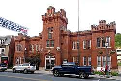 Pottsville Armory |
November 14, 1991 (#91001701) |
502 North Centre Street 40°41′28″N 76°11′54″W |
Pottsville | |
| 10 | Pottsville Downtown Historic District | 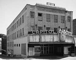 Pottsville Downtown Historic District |
March 1, 1982 (#82003819) |
Roughly bounded by Laurel Boulevard, Railroad, Morris and 4th Streets 40°40′59″N 76°11′41″W |
Pottsville | |
| 11 | Reading Railroad Passenger Station–Tamaqua | 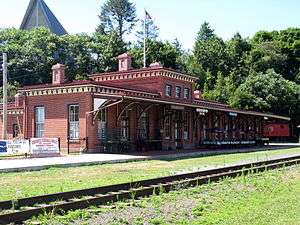 Reading Railroad Passenger Station–Tamaqua |
December 26, 1985 (#85003164) |
Off West Broad Street 40°47′52″N 75°58′14″W |
Tamaqua | |
| 12 | St. Paul's Union Church and Cemetery |  St. Paul's Union Church and Cemetery |
April 27, 1995 (#95000516) |
Junction of Township 798 and Legislative Route 4037, southwest corner, about 1 mile (1.6 km) east of Ringtown 40°51′33″N 76°12′38″W |
Union Township | |
| 13 | Schuylkill County Bridge No. 113 | 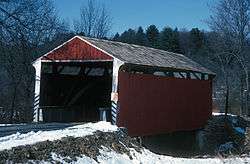 Schuylkill County Bridge No. 113 |
January 3, 1978 (#78002468) |
West of Rock off Pennsylvania Route 895 40°32′42″N 76°17′43″W |
Washington Township | |
| 14 | Schuylkill County Bridge No. 114 | 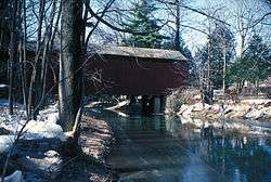 Schuylkill County Bridge No. 114 |
January 3, 1978 (#78002467) |
East of Rock off Pennsylvania Route 895 40°32′39″N 76°19′33″W |
Washington Township | |
| 15 | Swatara Furnace | 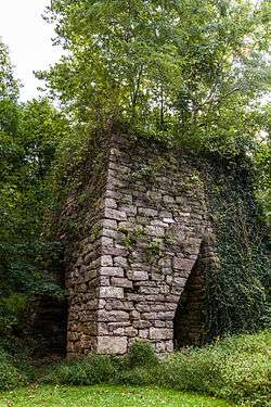 Swatara Furnace |
September 6, 1991 (#91001140) |
Old Forge Road east of Lebanon Reservoir, north of Suedberg 40°32′35″N 76°29′27″W |
Pine Grove Township | |
| 16 | Tamaqua Historic District | 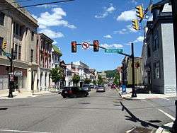 Tamaqua Historic District |
February 2, 2001 (#01000059) |
Roughly bounded by the Odd Fellows Cemetery, Rowe and Mauch Street, East End Avenue, Mountain Avenue, and West Cottage Avenue 40°47′59″N 75°57′29″W |
Tamaqua and Schuylkill Township | |
| 17 | D.G. Yuengling and Son Brewing Complex | 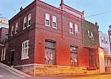 D.G. Yuengling and Son Brewing Complex |
February 1, 1985 (#85000180) |
5th and Mahantongo Streets 40°40′57″N 76°12′22″W |
Pottsville | |
| 18 | Frank D. Yuengling Mansion | 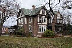 Frank D. Yuengling Mansion |
April 18, 1979 (#79002342) |
1440 Mahantongo Street 40°40′43″N 76°12′30″W |
Pottsville |
Former listing
| [3] | Name on the Register | Image | Date listed | Date removed | Location | City or town | Summary |
|---|---|---|---|---|---|---|---|
| 1 | Mt. Pleasant Historic District | January 7, 1988 (#87002211) | October 28, 2010 | Township Road 881 and Pennsylvania Route 901 at Mount Pleasant 40°42′39″N 76°20′19″W |
Foster Township |
gollark: Rule by fetuses, presumably.
gollark: Try reading better.
gollark: It's my infvalues result.
gollark: It should be decided by my social status decider algorithm™.
gollark: I don't know if there's actually some meaningful mechanism underlying it or whether it's just an aggregate of a bunch of things, but still.
See also
| Wikimedia Commons has media related to National Register of Historic Places in Schuylkill County, Pennsylvania. |
References
- The latitude and longitude information provided in this table was derived originally from the National Register Information System, which has been found to be fairly accurate for about 99% of listings. Some locations in this table may have been corrected to current GPS standards.
- "National Register of Historic Places: Weekly List Actions". National Park Service, United States Department of the Interior. Retrieved on August 14, 2020.
- Numbers represent an ordering by significant words. Various colorings, defined here, differentiate National Historic Landmarks and historic districts from other NRHP buildings, structures, sites or objects.
- The eight-digit number below each date is the number assigned to each location in the National Register Information System database, which can be viewed by clicking the number.
| Topics |  | |
|---|---|---|
| Lists by county |
| |
| Lists by city |
| |
| Other lists | ||
| ||
This article is issued from Wikipedia. The text is licensed under Creative Commons - Attribution - Sharealike. Additional terms may apply for the media files.