Japan National Route 282
National Route 282 (国道282号, Kokudō Nihyakuhachijūnigō) is a national highway of Japan connecting the cities of Morioka, the capital city of Iwate Prefecture, and Hirakawa in southern Aomori Prefecture. It travels south to north and has a total length of 124.4 kilometers (77.3 mi).
| ||||
|---|---|---|---|---|
| 国道282号 | ||||
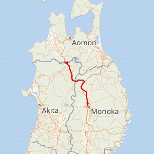
Japan National Route 282 highlighted in red | ||||
| Route information | ||||
| Length | 124.4 km[1] (77.3 mi) | |||
| Existed | 1 April 1970–present | |||
| Major junctions | ||||
| South end | in Morioka, Iwate | |||
| North end | in Hirakawa, Aomori | |||
| Highway system | ||||
| National highways of Japan Expressways of Japan
| ||||
Route description
National Route 282's starting point and southern terminus is located at an intersection along National Route 4, about half of a kilometer east of Iwate University. From there, it runs north concurrently with national routes 4 and 281 and crosses in to the city of Takizawa where it leaves the concurrency. From Takizawa northeast to its northern terminus in Hirakawa, it travels northwest parallel to the Tōhoku Expressway. It crosses briefly through Akita Prefecture before terminating at a junction with National Route 7 in Hirakawa in Aomori Prefecture.[2]
History
National Route 282 was established by the Cabinet of Japan in 1970 between Morioka and Ōdate in Akita Prefecture.[3] It was extended north to its current terminus in Hirakawa in 1982.[4] A bypass signed as National Route 282 running to the east of its original route through Nishine, Iwate was completed on 1 April 2016.[5]
Gallery
- Japan National Route 282
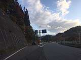 The northern terminus of National Route 282 at National Route 7 in Hirakawa, Aomori
- National Route 282 in Kosaka, Akita
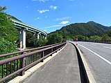 National Route 282 running parallel to the Tōhoku Expressway
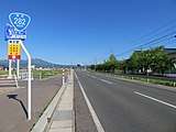 National Route 282 in Hachimantai, Iwate
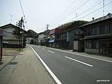 National Route 282 in Hachimantai, Iwate
Major intersections
All junctions listed are at-grade intersections unless noted otherwise.
| Prefecture | Location | km | mi | Destinations | Notes | ||
|---|---|---|---|---|---|---|---|
| Iwate | Morioka | 0.0 | 0.0 | Southern terminus; southern end of unsigned concurrency with national routes 4 and 281; highway continues south as National Route 4 | |||
| 1.7 | 1.1 | ||||||
| Takizawa | 9.1 | 5.7 | Iwate Prefecture Route 16 south – Koiwai | Northern end of unsigned concurrency with national routes 4 and 281, southern end of Iwate Prefecture Route 16 concurrency | |||
| 9.4 | 5.8 | Iwate Prefecture Route 16 east – Takizawa Station | Northern end of Iwate Prefecture Route 16 concurrency | ||||
| 9.5 | 5.9 | Iwate Prefecture Route 278 west – Mount Iwate, Amihari | |||||
| Hachimantai | 20.6 | 12.8 | Nishine Interchange (E4 exit 44) | ||||
| 21.0 | 13.0 | Former National Route 282 north – Hachimantai, Yakehashiri | |||||
| 25.0 | 15.5 | Iwate Prefecture Route 23 west (former National Route 282) – Hachimantai | |||||
| 28.0 | 17.4 | Iwate Prefecture Route 17 – Tairadate, Iwate, National Route 4 | |||||
| 29.5 | 18.3 | Former National Route 282 south | |||||
| 32.7 | 20.3 | Iwate Prefecture Route 45 (Kashiwadai-Matsuo route) west – Hachimantai, Matsuo-Hachimantai Station | |||||
| 53.9 | 33.5 | Ashiro Interchange (E4 exit 47) | |||||
| 54.5 | 33.9 | Iwate Prefecture Route 6 east – Ninohe, Jōbōji, National Route 4 | |||||
| 65.8 | 40.9 | Iwate Prefecture Route 195 west – Hanawa mine | |||||
| Akita | Kazuno | 81.1 | 50.4 | Northern terminus of National Route 341 | |||
| 84.7 | 52.6 | Kazuno-Hachimantai Interchange (E4 exit 48) | |||||
| 86.7 | 53.9 | Akita Prefecture Route 66 – Central Hanawa, Osarizawa copper mine | |||||
| 88.7 | 55.1 | Akita Prefecture Route 195 east – Hanawa ski area | |||||
| 96.4 | 59.9 | Eastern terminus of National Route 285 | |||||
| 97.3 | 60.5 | Akita Prefecture Route 313 west | |||||
| Kosaka | 103.9 | 64.6 | Northern terminus of National Route 341 | ||||
| Aomori | Hirakawa | 124.4 | 77.3 | Northern terminus | |||
1.000 mi = 1.609 km; 1.000 km = 0.621 mi
| |||||||
See also


References
- "一般国道の路線別、都道府県別道路現況" [Road statistics by General National Highway route and prefecture] (PDF) (in Japanese). Ministry of Land, Infrastructure, Transport and Tourism. Retrieved 18 February 2020.
- "国道282号盛岡市-碇ヶ関村" (in Japanese). August 2008. Retrieved 29 October 2019.
- "一般国道の路線を指定する政令" (in Japanese). Retrieved 10 October 2019 – via Wikisource.
- "平成27年度全国道路・街路交通情勢調査 一般交通量調査 箇所別基本表" (PDF) (in Japanese). Retrieved 25 October 2019.
- "国道282号・県道の一部区間移管により市が管理しています" (PDF) (in Japanese). 12 May 2016. Retrieved 25 October 2019.
External links

