Japan National Route 15
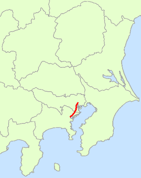
National Route 15 (国道15号, Kokudō Jūgo-gō) is a national highway connecting Tokyo and Yokohama in Japan.[2] It is commonly referred to as Dai-Ichi Keihin (第一京浜).
| ||||
|---|---|---|---|---|
| 国道15号 | ||||
 | ||||
| Route information | ||||
| Length | 29.2 km[1] (18.1 mi) | |||
| Existed | 4 December 1952–present | |||
| Major junctions | ||||
| North end | ||||
| South end | ||||
| Highway system | ||||
| National highways of Japan Expressways of Japan
| ||||

Route data
- Length: 29.2 km (18.1 mi)
- Origin: Nihonbashi, Chūō, Tokyo (originates at junction with Route 1, Route 4, Route 6, Route 14, Route 17 and Route 20)
- Terminus: Yokohama (ends at Junction with Route 1)
- Major cities: Kawasaki
History
Municipalities passed through
Intersects with
- Tokyo
- Routes 1, 4, 6, 14, 17 and 20 at the origin
- Route 130 at Minato-ku
- Yashio Bypass, Route 357 at Shinagawa-ku
- Route 131 at Ōta-ku
- Kanagawa Prefecture
- Routes 132 and 409 at Kawasaki-ku, Kawasaki
- Route 1, at the terminus
gollark: @all staff ever Please fix markets being unable to sell queen bees.
gollark: Why would it be that? That's longer and thus impossible by Occam's razor.
gollark: You're clearly bad and unaware of how potatOS was potatOSed.
gollark: Just disable them?
gollark: The Hypercycle version.
References
- "一般国道の路線別、都道府県別道路現況" [Road statistics by General National Highway route and prefecture] (PDF) (in Japanese). Ministry of Land, Infrastructure, Transport and Tourism. Retrieved 19 February 2020.
- 一般国道15号 (in Japanese). Ministry of Land, Infrastructure, Transport and Tourism. Kanto Regional Development Bureau. Archived from the original on 17 July 2011. Retrieved 29 November 2010.
| Wikimedia Commons has media related to Route 15 (Japan). |
This article is issued from Wikipedia. The text is licensed under Creative Commons - Attribution - Sharealike. Additional terms may apply for the media files.