Japan National Route 42
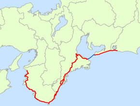
National Route 42 (国道42号, Kokudō yonjūni-gō), also called Kumano Kaidō or Tropical Route is a national highway connecting Hamamatsu, Shizuoka and Wakayama, Wakayama in Japan. Part of the route requires crossing Ise Bay on the Ise-wan Ferry.[2][3]
| ||||
|---|---|---|---|---|
| 国道42号 | ||||
 | ||||
| Route information | ||||
| Length | 504.6 km[1] (313.5 mi) | |||
| Existed | 1 April 1959–present | |||
| Major junctions | ||||
| East end | Hamamatsu | |||
| West end | Wakayama | |||
| Highway system | ||||
| National highways of Japan Expressways of Japan
| ||||
It is the 8th longest national highway in Japan.
Route data
History
Route 42 was originally designated in January 1945 as a section of Route 41 (the Kumano Highway), which ran to Tokyo. This ran concurrent with Route 1 (now Route 1/Route 23). On 18 May 1953 Route 41 was classified as a Class 2 highway and redesignated as Route 170, which was later redesignated as Route 42 when the route was promoted to a Class 1 highway.
Intersects with
- Shizuoka Prefecture
- Aichi Prefecture
- Mie Prefecture
- Route 167
- Route 23
- Route 166
- Ise Expressway
- Route 368
- Kisei Expressway
- Route 260
- Route 425
- Route 311
- Route 309
- Route 311
- Wakayama Prefecture
- Route 168
- Route 371
- Route 311
- Hanwa Expressway
- Route 424
- Route 425
- Yuasa-Gobō Bypass
- Route 480
- Route 24
- Route 26
gollark: I'm doing GCSEs too, still not certain exactly what's happening with that.
gollark: Lossy video compression formats also good for longer videos.
gollark: GIF bad APNG good
gollark: Start breathing a cooler gas?
gollark: Ozone, a form of oxygen, is even worse.
References
- "一般国道の路線別、都道府県別道路現況" [Road statistics by General National Highway route and prefecture] (PDF) (in Japanese). Ministry of Land, Infrastructure, Transport and Tourism. Retrieved 19 February 2020.
- 一般国道42号 (in Japanese). Kinki Regional Development Bureau, Ministry of Land, Infrastructure, Transport and Tourism. Retrieved 29 November 2010.
- 一般国道42 号 (in Japanese). Kinki Regional Development Bureau, Ministry of Land, Infrastructure, Transport and Tourism. Retrieved 29 November 2010.
This article is issued from Wikipedia. The text is licensed under Creative Commons - Attribution - Sharealike. Additional terms may apply for the media files.
