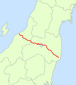
Japan National Route 49
National Route 49 is a national highway of Japan connecting Iwaki, Fukushima and Chūō-ku, Niigata in Japan, with a total length of 246.4 km (153.11 mi).
| ||||
|---|---|---|---|---|
| 国道49号 | ||||
 | ||||
| Route information | ||||
| Length | 246.4 km[1] (153.1 mi) | |||
| Existed | 1 April 1963–present | |||
| Highway system | ||||
| National highways of Japan Expressways of Japan
| ||||
History
Route 49 was designated on 18 May 1953 as National Route 115, and this was redesignated as Route 49 when Route 115 was promoted to a Class 1 highway.
Route data
Intersecting routes
gollark: Ideally, pylon-of-civilization-hunting von Neumann machines, but those might not be practical yet.
gollark: The obvious solution to this """voting"" is to send really fast people out to gather all pylons of civilization and move them to a central base.
gollark: Yes. This is a good idea. I don't like it.
gollark: Any civilized person should aim to overthrow the system and improve this sort of thing.
gollark: Imagine using first past the post voting, instead of obviously superior approval voting.
References
- "一般国道の路線別、都道府県別道路現況" [Road statistics by General National Highway route and prefecture] (PDF) (in Japanese). Ministry of Land, Infrastructure, Transport and Tourism. Retrieved 19 February 2020.
| Wikimedia Commons has media related to Route 49 (Japan). |
This article is issued from Wikipedia. The text is licensed under Creative Commons - Attribution - Sharealike. Additional terms may apply for the media files.
