Japan National Route 5
National Route 5 (国道5号, Kokudō Go-gō) is a major highway on the island and prefecture of Hokkaido in northern Japan. The 288.5-kilometer (179.3 mi) highway begins at an intersection with National Routes 279 and 278 in Hakodate. It travels north across the southern half of the island, traveling through Otaru where it curves to the east toward its endpoint at an intersection with National Route 12 in Chūō-ku, Sapporo.
| ||||
|---|---|---|---|---|
| 国道5号 | ||||
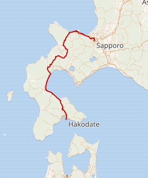
Japan National Route 5 highlighted in red | ||||
| Route information | ||||
| Length | 288.5 km[1] (179.3 mi) | |||
| Major junctions | ||||
| South end | ||||
| North end | ||||
| Location | ||||
| Major cities | Oshamanbe Niseko Kutchan Otaru | |||
| Highway system | ||||
| National highways of Japan Expressways of Japan
| ||||

Route description
Overlapping sections
- In Oshamanbe, from Kunnui intersection to Asahihama intersection: Route 230
- From Kutchan (North-4 West-1 intersection) to Kyōwa (Kunitomi intersection): Route 276
- From Yoichi (Yoichi Station intersection) to Otaru (Inaho 2-18 intersection): Route 229
Municipalities passed through
- Oshima Subprefecture
- Hakodate - Nanae - Mori - Yakumo - Oshamanbe
- Shiribeshi Subprefecture
- Kuromatsunai - Rankoshi - Niseko - Kyōwa - Niki - Yoichi - Otaru
- Ishikari Subprefecture
History
National Route 5 traces its origin to the Sapporo Hondō, a road designed by Horace Capron, in 1872. Capron was an American advisor to the Hokkaido Development Commission who was paid to assist in the development of Sapporo as a planned city. The Sapporo Hondō connected Sapporo to Hakodate at the southern end of the Hokkaido where sea connections to the main island of Japan, Honshu, were located. The Sapporo Hondō was completed in 1877.[2]
On 4 December 1952, the Cabinet of Japan designated the Sapporo Hondō as First Class National Highway 5.[3] On 1 April 1965, it was reclassified as National Route 5.[4]
Gallery
- Japan National Route 5
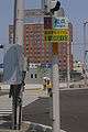 National Route 5's origin point and southern terminus in Hakodate
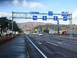 National Route 5 in Nanae near Shin-Hakodate-Hokuto Station
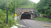 Inaho Tunnel carries National Route 5 under Inaho Pass
.jpg) National Route 5 in Kyōwa
National Route 5 in Kyōwa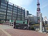 The origin point of Hokkaido's roads in Sapporo, the northern terminus of National Route 5 lies 350 meters to the north of the marker
Major junctions
The route lies entirely within Hokkaido.
| Location | km | mi | Destinations | Notes | |||
|---|---|---|---|---|---|---|---|
| Hakodate | 0.0 | 0.0 | Southern terminus; highway continues south as National Route 279 | ||||
| 1.9 | 1.2 | Hokkaido Route 571 east – Goryōkaku Park | |||||
| 3.2 | 2.0 | Hokkaido Route 347 – Goryōkaku Park | |||||
| 5.4 | 3.4 | ||||||
| 6.1 | 3.8 | ||||||
| Nanae | 11.1 | 6.9 | Southern end of Hokkaido Route 969 concurrency | ||||
| 11.4 | 7.1 | Hokkaido Route 969 west – Hokuto | Northern end of Hokkaido Route 969 concurrency | ||||
| 15.3 | 9.5 | ||||||
| 19.3 | 12.0 | Nanae-Fujishiro Interchange (E5 exit 4) | |||||
| 20.1 | 12.5 | ||||||
| 21.1 | 13.1 | Hokkaido Route 96 south – Hokuto | |||||
| 28.7 | 17.8 | Hokkaido Route 43 north – Shikabe, Ōnuma Quasi-National Park | |||||
| Mori | 30.9 | 19.2 | Hokkaido Route 43 south | ||||
| 42.4 | 26.3 | ||||||
| 43.1 | 26.8 | Hokkaido Route 794 north – Central Mori | |||||
| 43.9 | 27.3 | Hokkaido Route 606 – Central Mori, Torizakihakkei | |||||
| 45.6 | 28.3 | Hokkaido Route 1028 east – Central Mori | |||||
| Yakumo | 62.8 | 39.0 | Otoshibe Interchange (E5 exit 8); the short road leading to/from the interchange and Route 5 is designated as Hokkaido Route 1155 | ||||
| 64.9 | 40.3 | Hokkaido Route 573 south | |||||
| 73.1 | 45.4 | Hokkaido Route 42 west – Central Yakumo | |||||
| 73.8 | 45.9 | Hokkaido Route 572 east – Yakumo Port | |||||
| 75.9 | 47.2 | ||||||
| 77.1 | 47.9 | Hokkaido Route 1029 south – Central Yakumo | |||||
| Oshamambe | 95.9 | 59.6 | Southern end of National Route 230 concurrency | ||||
| 104.6 | 65.0 | Hokkaido Route 1141 west | |||||
| 105.9 | 65.8 | Northern end of National Route 230 concurrency | |||||
| 107.6 | 66.9 | Oshamambe Interchange (E5 exit 11) | |||||
| 115.6 | 71.8 | Hokkaido Route 842 west – Futamata Spa | |||||
| 120.8 | 75.1 | Hokkaido Route 9 north – Suttsu, Central Kuromatsunai | |||||
| Kuromatsunai | 126.4 | 78.5 | Hokkaido Route 266 (Milk Country Road) west – Central Kuromatsunai | Southern end of Hokkaido Route 266 concurrency | |||
| 127.0 | 78.9 | Hokkaido Route 266 east – Toyoura | Northern end of Hokkaido Route 266 concurrency | ||||
| 130.6 | 81.2 | Hokkaido Route 265 west – Suttsu, Central Kuromatsunai | |||||
| 132.1 | 82.1 | Hokkaido Route 344 east – Higashikawa | |||||
| 132.3 | 82.2 | Kuromatsunai Interchange (E5A exit 2) | |||||
| Rankoshi | 141.6 | 88.0 | Hokkaido Route 752 north | ||||
| 146.7 | 91.2 | Hokkaido Route 934 north | |||||
| 150.0 | 93.2 | Hokkaido Route 267 north – Suttsu | |||||
| 152.9 | 95.0 | Hokkaido Route 525 north – Rankoshi Station | |||||
| 153.8 | 95.6 | Hokkaido Route 229 – Iwanai, Suttsu, Rankoshi Station | |||||
| 160.5 | 99.7 | Hokkaido Route 207 north – Chisenupuri, Niseko Konbu Onsen | |||||
| Niseko | 160.8 | 99.9 | Hokkaido Route 32 south – Toyoura | ||||
| 167.1 | 103.8 | Hokkaido Route 791 south | |||||
| 171.0 | 106.3 | Hokkaido Route 66 – Rusutsu, Makkari, Iwanai, Niseko Resort Area | |||||
| 172.4 | 107.1 | Hokkaido Route 792 west – Niseko Station | |||||
| Kutchan | 179.5 | 111.5 | Hokkaido Route 631 west – Niseko Resort Area | ||||
| 181.9 | 113.0 | Hokkaido Route 478 east – Kyōgoku | |||||
| 182.6 | 113.5 | Hokkaido Route 343 west – Niseko Resort Area | |||||
| 183.6 | 114.1 | Hokkaido Route 58 west – Niseko Resort Area | |||||
| 184.2 | 114.5 | Southern end of National Route 276 concurrency | |||||
| Kyōwa | 193.1 | 120.0 | Hokkaido Route 604 west – Iwanai | ||||
| 197.8 | 122.9 | Northern end of National Route 276 concurrency | |||||
| Niki | 210.2 | 130.6 | Hokkaido Route 1022 east – Akaigawa, Ginzan Station | ||||
| 220.6 | 137.1 | Hokkaido Route 455 east – Niki Station | |||||
| Yoichi | 223.5 | 138.9 | |||||
| 224.6 | 139.6 | Hokkaido Route 755 south | |||||
| 224.7 | 139.6 | ||||||
| 225.0 | 139.8 | Hokkaido Route 228 east – Yoichi Station | Southern end of National Route 229 and Hokkaido Route 228 concurrency | ||||
| 225.7 | 140.2 | Hokkaido Route 228 west – Shakotan, Furubira | Northern end of Hokkaido Route 228 concurrency | ||||
| 229.8 | 142.8 | Hokkaido Route 1092 south | |||||
| Otaru | 236.1 | 146.7 | Hokkaido Route 956 (Otaru Loop Route) east – Shioya Station | ||||
| 243.8 | 151.5 | ||||||
| 244.4 | 151.9 | Hokkaido Route 454 (Chūō-dōri) east – Otaru Port, Otaru Canal | |||||
| 244.7 | 152.0 | Hokkaido Route 697 south – Asahi View Point, Mount Tengu | Northern end of National Route 229 concurrency, southern end of Hokkaido Route 697 concurrency | ||||
| 246.4 | 153.1 | Hokkaido Route 697 north – Ferry Terminal, Parute Port | Northern end of Hokkaido Route 697 concurrency | ||||
| 247.5 | 153.8 | Hokkaido Route 17 (Rinkosen) north – Otaru Port, Parute Port | Otaru Interchange (E5A exit 11) | ||||
| 251.0 | 156.0 | ||||||
| 260.7 | 162.0 | Hokkaido Route 225 east – Zenibako Station | |||||
| 262.4 | 163.0 | ||||||
| 262.7 | 163.2 | Hokkaido Route 1226 north – Central Zenibako | |||||
| 263.7 | 163.9 | Interchange | |||||
| Sapporo | 276.4 | 171.7 | Hokkaido Route 128 (Oiwake-dōri) north – Shinkawa | ||||
| 277.2 | 172.2 | Hokkaido Route 124 east – Sapporo Station, Chitose | Sapporo-nishi Interchange (E5A exit 6); southern end of National Route 5 serving as a frontage road to the Sasson Expressway | ||||
| 279.6 | 173.7 | Hokkaido Route 452 (Shimoteine-dōri) – Maeda, Hachiken Station | |||||
| 280.6 | 174.4 | Hokkaido Route 125 (Shinkawa-dōri) – Ishikari Bay New Port, Maeda, Sapporo Station | |||||
| 281.2 | 174.7 | Shinkawa Interchange (E5A exit 5) | |||||
| 283.4 | 176.1 | Sapporo-kita Interchange (E5A exit 4) | |||||
| 284.1 | 176.5 | Northern end of National Route 5 serving as a frontage road to the Sasson Expressway | |||||
| 285.3 | 177.3 | Hokkaido Route 89 – Hachiken, Motomachi | |||||
| 287.6 | 178.7 | Hokkaido Route 273 | |||||
| 288.5 | 179.3 | Northern terminus, street continues as Sōseikawa-dōri | |||||
1.000 mi = 1.609 km; 1.000 km = 0.621 mi
| |||||||
See also

References
- "一般国道の路線別、都道府県別道路現況" [Road statistics by General National Highway route and prefecture] (PDF) (in Japanese). Ministry of Land, Infrastructure, Transport and Tourism. Retrieved 19 February 2020.
- "開拓を進めた長距離馬車道" (in Japanese). Retrieved 24 January 2020.
- "二級国道の路線を指定する政令 (昭和二十八年)". Wikisource (in Japanese). Retrieved 24 January 2020.
- "二級国道の路線を指定する政令 (1962年)". Wikisource (in Japanese). Retrieved 24 January 2020.
External links
