Interstate 41
Interstate 41 (I-41) is a 176.33-mile-long (283.78 km) north–south Interstate Highway connecting the interchange of I-94 and U.S. Route 41 (US 41), located 0.9 miles (1.4 km) south of the Wisconsin–Illinois border at the end of the Tri-State Tollway in metropolitan Chicago, to an interchange with I-43 in metropolitan Green Bay, Wisconsin. The designation travels concurrently with US 41, I-894, US 45, I-43, and sections of I-94 in Wisconsin and Illinois. The route was officially added to the Interstate Highway System on April 7, 2015,[1] and connects Milwaukee and Green Bay with the Fox Cities.
| |||||||||
|---|---|---|---|---|---|---|---|---|---|
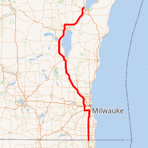
I-41 highlighted in red | |||||||||
| Route information | |||||||||
| Maintained by WisDOT and IDOT | |||||||||
| Length | 176.33 mi (283.78 km) | ||||||||
| Existed | April 7, 2015[1]–present | ||||||||
| History | Approved for designation in 2012[2] | ||||||||
| Major junctions | |||||||||
| South end | |||||||||
| |||||||||
| North end | |||||||||
| Location | |||||||||
| States | Illinois, Wisconsin | ||||||||
| Counties | IL: Lake WI: Kenosha, Racine, Milwaukee, Waukesha, Washington, Dodge, Fond du Lac, Winnebago, Outagamie, Brown | ||||||||
| Highway system | |||||||||
| |||||||||

Route description
I-41 begins at the I-94/US 41 interchange in Russell, Illinois, located 0.9 miles (1.4 km) south of the Wisconsin–Illinois border at the end of the Tri-State Tollway. The highway continues north concurrently with I-94 to the Mitchell Interchange in Milwaukee, turns west to run concurrently with I-894 and I-43 to the Hale Interchange (forming a brief wrong-way concurrency with I-43), and turns north to run concurrently with I-894 and US 45 to the Zoo Interchange, with the US 45 concurrency continuing until the I-41/US 41/US 45 split near Richfield. The Interstate roughly parallels I-43, which runs north–south along Lake Michigan from Milwaukee to Green Bay. I-41 runs through the Fox Valley (including the cities of Fond du Lac, Oshkosh and Appleton, along with the Fox Cities) and Green Bay, where it ends at the I-43 interchange. The Interstate is approximately 176 miles (283 km) long and located almost entirely within the state of Wisconsin, and is completely concurrent with a slightly adjusted alignment of US 41 to its termination in Green Bay.[3]
History
The freeway portion of US 41 and US 45 from Milwaukee through the Fox Valley to Green Bay was proposed and designated as an Interstate Highway as part of the 2005 highway funding bill (Safe, Accountable, Flexible, Efficient Transportation Equity Act: A Legacy for Users).[4]
In the initial language of the bill, the route was named Interstate 41, which correlates with the U.S. Highway it parallels and also complies with the Interstate naming guidelines through the American Association of State Highway and Transportation Officials (AASHTO). The final bill omitted the I-41 designation. In 2009, Green Bay officials began a campaign to have US 41 designated as a northern extension of I-55 from its current termination in Chicago, with the alternative being designated as a spur of I-43.[5][6] At the spring meeting of the Special Committee on U.S. Route Numbers of AASHTO on May 18, 2012, the I-55 designation was discussed by the committee. Coordination would have been required with the Federal Highway Administration (FHWA) and the Illinois Department of Transportation (IDOT) on the I-55 designation.
However, IDOT officials were not interested in signing an extension of I-55 from its Chicago terminus to the state line. Therefore, the Wisconsin Department of Transportation (WisDOT) decided to seek a different designation not requiring the cooperation of their Illinois counterparts. Four designations were proposed by WisDOT and put up for public review: two new primary designations (I-41 and I-47) and two auxiliary designations (I-594 and I-643).[7] At the end of October 2012, WisDOT submitted I-41 to AASHTO for consideration at their fall Special Committee meeting, where it was conditionally approved on November 16, 2012, pending FHWA concurrence.[2] Official approval of I-41 then hinged on weight limit exceptions being approved for the route,[8] which initially passed the United States House of Representatives as H.R. 4745 and awaited a United States Senate vote as S. 2438,[9] but were later passed in a different bill (H.R. 83) on December 16, 2014.[10][11][12] On April 9, 2015, Wisconsin Governor Scott Walker announced that the FHWA had approved I-41 as part of the Interstate Highway System.[13] According to WisDOT, the approval came two days earlier.[1]
WisDOT replaced or modified 3,500 signs before and near September 2015 after coordination with IDOT and the FHWA (signs erected in 2014 and into 2015 before approval of the designation had the Interstate 41 shield obscured until approval).[14][15] Over the next 5–10 years, shoulders are slated to be rebuilt as older parts of the highway are upgraded.[16] The re-designation to Interstate status also makes the route subject to the Highway Beautification Act, meaning current advertising billboards along the Milwaukee to Green Bay portion of the road can no longer be upgraded or enlarged, nor can new signs be added.[17]
Exit list
| County | Location | mi | km | Exit[18][19] | Destinations | Notes |
|---|---|---|---|---|---|---|
| Lake | Newport Township | 0.00 | 0.00 | 1B | Southern end of I-94/US 41 concurrency; southbound entrance only from Frontage Road, acts as the entrance ramp from Russell Road to I-94 east | |
| 0.76 | 1.22 | 1A | Signed as exit 1 northbound; exit numbers based on I-94's mile markers | |||
| 0.90 0.00 | 1.45 0.00 | Illinois–Wisconsin state line | ||||
| Kenosha | Pleasant Prairie | 2.04 | 3.28 | 347 | ||
| 3.43 | 5.52 | 345 | ||||
| Kenosha | 5.07 | 8.16 | 344 | To 71st Street | ||
| Somers | 6.59 | 10.61 | 342 | Kenosha Regional Airport | ||
| 8.35 | 13.44 | 340 | ||||
| Town of Paris | 10.07 | 16.21 | 339 | |||
| Racine–Kenosha county line | Mount Pleasant–Paris village/town line | 12.08 | 19.44 | 337 | ||
| Racine | Mount Pleasant | 13.95 | 22.45 | 335 | ||
| Town of Yorkville | 15.96– 16.01 | 25.69– 25.77 | 333 | |||
| Caledonia | 19.64 | 31.61 | 329 | |||
| Town of Raymond | 21.67 | 34.87 | 327 | |||
| 23.17 | 37.29 | 326 | Seven Mile Road | Current southern terminus of WIS 241 | ||
| Caledonia | 24.10 | 38.79 | 325 | Exit permanently closed; northbound exit and southbound entrance | ||
| Milwaukee | Oak Creek | 324 | Elm Road | Exit currently under construction, will replace exit 325[20] | ||
| 26.39 | 42.47 | 322 | ||||
| 28.47 | 45.82 | 321 | Drexel Avenue | |||
| 29.41 | 47.33 | 320 | ||||
| Milwaukee | 30.38 | 48.89 | 319 | |||
| 31.08 | 50.02 | 318 | ||||
| 32.37 | 52.09 | 317 | ||||
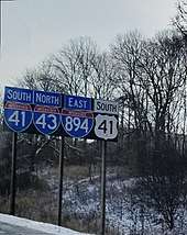
| 32.53– 32.69 | 52.35– 52.61 | 10 316 | Northern end of I-94 concurrency; eastern end of I-43 wrong-way concurrency; eastern end of I-894 concurrency; Mitchell Interchange | |||
| 33.60 | 54.07 | 9 | No access is allowed from I-94 west or to I-94 east; exit numbers based on I-894's mile markers | |||
| Greenfield | 34.64 | 55.75 | 8 | |||
| 35.64 | 57.36 | 7 | South 60th Street | |||
| 36.66 | 59.00 | 5B | South 76th Street | Northbound exit and southbound entrance | ||
| 36.66– 37.14 | 59.00– 59.77 | 5A | South 76th Street, South 84th Street | Southbound exit and northbound entrance | ||
| 36.86 | 59.32 | 5A | Northbound exit and southbound entrance | |||
| Milwaukee | 38.06 | 61.25 | 4 | Western end of I-43 concurrency; southern end of the US 45 concurrency; Hale Interchange | ||
| Greenfield | 39.32 | 63.28 | 3 | |||
| 39.93 | 64.26 | 2B | Oklahoma Avenue | Southbound exit and northbound entrance | ||
| West Allis | 40.67 | 65.45 | 2A | National Avenue | Southbound exit to westbound National Avenue only | |
| 40.93 | 65.87 | 1E | Lincoln Avenue | Southbound exit and northbound entrance | ||
| 41.89 | 67.42 | 1D | ||||
| Milwaukee | 42.61 | 68.57 | 1 38 | Western end of I-894 concurrency; signed as exits 1A (east) and 1B (west) northbound and exits 38A (west) and 38B (east) southbound; Zoo Interchange | ||
| Wauwatosa | 43.36– 43.60 | 69.78– 70.17 | 39 | Northbound exit is not signed for Wisconsin Avenue; exit numbers based on US 45's mile markers | ||
| 44.14– 44.56 | 71.04– 71.71 | 40 | Watertown Plank Road, Swan Boulevard | Southbound exit not signed for Swan Boulevard | ||
| 44.94 | 72.32 | 42A | Southbound exit not signed for WIS 100 | |||
| 45.54 | 73.29 | 42B | North Avenue west | |||
| 46.59 | 74.98 | 43 | Burleigh Street | |||
| 47.59 | 76.59 | 44 | Three-level diamond interchange; access roads for the adjacent Harley-Davidson and Penzeys Spices plants are also part of the interchange | |||
| Milwaukee | 48.69 | 78.36 | 45 | |||
| 49.52 | 79.69 | 46 | Southern end of WIS 100 concurrency | |||
| 51.05 | 82.16 | 47 | ||||
| 51.85 | 83.44 | 47B | Exit numbers based on US 41's mile markers | |||
| 52.15– 52.94 | 83.93– 85.20 | 48 | ||||
| Waukesha | Menomonee Falls | 54.64– 54.77 | 87.93– 88.14 | 50 | Northern end of WIS 100 concurrency; signed as exits 50A (east) and 50B (west); WIS 74 designation removed on November 1, 2015 | |
| 55.45 | 89.24 | 51 | Pilgrim Road | Signed as exits 51A (north) and 51B (south) | ||
| Washington | Germantown | 56.68 | 91.22 | 52 | ||
| 58.63 | 94.36 | 54 | Southern end of WIS 167 concurrency | |||
| 61.64 | 99.20 | 57 | Northern end of WIS 167 concurrency | |||
| Richfield | 63.27 | 101.82 | 59 | Northern end of US 45 concurrency; northbound exit and southbound entrance | ||
| 64.37 | 103.59 | 60 | Signage reads WIS 145; ramp signage reads CTH-FD TO WIS 145 | |||
| Slinger | 68.17 | 109.71 | 64 | Signed as exits 64A (east, Jackson) and 64B (west, Slinger, Hartford) northbound | ||
| Town of Polk | 70.45 | 113.38 | 66 | Little Switzerland Ski Area, Slinger Speedway | ||
| Town of Hartford | 72.12 | 116.07 | 68 | |||
| Town of Addison | 76.37 | 122.91 | 72 | |||
| Town of Wayne | 79.59 | 128.09 | 76 | |||
| Dodge | Town of Theresa | 85.22 | 137.15 | 81 | Horicon Marsh State Wildlife Area Southern Section | |
| Lomira | 89.24 | 143.62 | 85 | Kettle Moraine State Forest Northern Unit | ||
| Town of Lomira | 91.29 | 146.92 | 87 | Horicon Marsh State Wildlife Area Northern Section | ||
| Fond du Lac | Town of Byron | 96.10 | 154.66 | 92 | ||
| Fond du Lac | 99.71– 99.72 | 160.47– 160.48 | 95 | Southern end of US 45 concurrency | ||
| 101.01 | 162.56 | 97 | ||||
| 101.84 | 163.90 | 98 | Former US 151; Fond du Lac County Airport | |||
| 103.74 | 166.95 | 99 | Northern end of US 45 concurrency | |||
| North Fond du Lac | 104.24 | 167.76 | 101 | |||
| Town of Eldorado | 110.27 | 177.46 | 106 | |||
| Winnebago | Town of Nekimi | 117.47 | 189.05 | 113 | ||
| Oshkosh | 120.22 | 193.48 | 116 | Wittman Regional Airport | ||
| 121.64 | 195.76 | 117 | 9th Avenue | |||
| 123.14 | 198.17 | 119 | ||||
| 125.05 | 201.25 | 120 | To US 10 west not signed southbound | |||
| 128.10 | 206.16 | 124 | ||||
| Neenah | 133.30 | 214.53 | 129 | Bell Street, Breezewood Lane | ||
| 134.67 | 216.73 | 131 | ||||
| 135.61 | 218.24 | 132 | Main Street, Oak Ridge Road | No entrance ramps | ||
| Fox Crossing | 136.35 | 219.43 | 133 | |||
| 137.81 | 221.78 | 134 | ||||
| 137.86 | 221.86 | |||||
| 139.62 | 224.70 | 136 | ||||
| Outagamie | Town of Grand Chute | 140.88 | 226.72 | 137 | ||
| 141.65 | 227.96 | 138 | ||||
| 142.71 | 229.67 | 139 | To CTH-A not signed southbound; Neuroscience Group Field at Fox Cities Stadium | |||
| 145.67 | 234.43 | 142 | ||||
| Appleton | 147.67 | 237.65 | 144 | |||
| 148.59– 148.61 | 239.13– 239.16 | 145 | ||||
| Little Chute | 151.10 | 243.17 | 146 | |||
| Kaukauna | 152.78 | 245.88 | 148 | |||
| 153.99 | 247.82 | 150 | ||||
| Town of Kaukauna | 158.25 | 254.68 | 154 | |||
| Brown | Town of Lawrence | 161.21 | 259.44 | 157 | ||
| 181.87 | 292.69 | 161 | ||||
| Ashwaubenon | 167.12 | 268.95 | 163A | |||
| 167.40 | 269.40 | 163B | Northbound exit and southbound entrance | |||
| 168.39 | 271.00 | 164A | ||||
| 169.36– 169.46 | 272.56– 272.72 | 164B | To WIS 57 not signed northbound | |||
| 171.14 | 275.42 | 167 | Lambeau Field | |||
| Green Bay | 172.18 | 277.10 | 168A | Southern end of WIS 32 concurrency | ||
| Howard | 173.17 | 278.69 | 168B-C | Northern end of WIS 32 concurrency | ||
| 174.75 | 281.23 | 170A | Southern end of US 141 concurrency | |||
| 175.16– 175.43 | 281.89– 282.33 | 170B | Northern end of US 41 concurrency; northern end of US 141 concurrency; northern terminus of I-43; I-41 terminates at northbound entrance ramp from I-43 | |||
1.000 mi = 1.609 km; 1.000 km = 0.621 mi
| ||||||
See also


References
- US 41 Interstate Conversion Team (April 9, 2015). "US 41 Interstate Conversion: Wisconsin State Line–Green Bay, in Kenosha, Racine, Milwaukee, Waukesha, Washington, Dodge, Fond du Lac, Winnebago, Outagamie, and Brown Counties". Wisconsin Department of Transportation. Archived from the original on April 10, 2015.
- Special Committee on U.S. Route Numbering (November 16, 2012). "SCOH Report from Special Committee on U.S. Route Numbering Annual Meeting" (PDF) (Report). Washington, DC: American Association of State Highway and Transportation Officials. Archived (PDF) from the original on June 3, 2019. Retrieved December 23, 2012.
- Google (April 7, 2014). "Overview Map of Interstate 41" (Map). Google Maps. Google. Retrieved April 7, 2014.
- Behnke, Duke (September 5, 2007). "'Interstate 41' on Near Horizon". The Post-Crescent. Appleton, WI. Archived from the original on July 14, 2014. Retrieved August 1, 2013.
- Jagannathan, Malavika (February 8, 2009). "Officials Push to Rename Revamped US 41". Green Bay Press Gazette. Retrieved July 10, 2009.
- Staff (February 9, 2009). "New Business, Minutes of the Village Board Meeting" (PDF). Village of Howard, Wisconsin. Retrieved July 10, 2009.
- Staff (May 2012). US 41 Public Information Meeting Report (PDF) (Report). Wisconsin Department of Transportation. Archived from the original (PDF) on July 14, 2014. Retrieved December 23, 2012.
- Bollier, Jeff (December 13, 2014). "Interstate Upgrade for 41 Clears Hurdle". The Post-Crescent. Appleton, WI. p. A4.
- "Appropriations by Fiscal Year: FY2015". United States Congress. Retrieved September 18, 2014.
- Cassidy, Tabitha (July 5, 2013). "Petri, Ribble Propose Legislation Allowing Existing Trucks to Use the Future I-41". The Post-Crescent. Appleton, WI. Archived from the original on November 9, 2014. Retrieved August 1, 2013.
- 113th Congress (December 16, 2014). "H.R.83: Making Consolidated Appropriations for the Fiscal Year Ending September 30, 2015, and for Other Purposes". U.S. Government Printing Office. Public Law No: 113-235.
- Bollier, Jeff & Shuda, Nathaniel (December 12, 2014). "Interstate 41 Clears Major Congressional Hurdle". The Oshkosh Northwestern.
- Srubas, Paul (April 9, 2015). "US 41 Named Officially to Interstate Highway System". Green Bay Press Gazette.
- Rudat, Kim (December 15, 2014). "Federal Legislation Will Enable Converting US 41 to an Interstate" (Press release). Wisconsin Department of Transportation. Archived from the original on January 3, 2015. Retrieved January 3, 2014.
- Crisp, Lacey (July 8, 2014). "'Highway 41' Makes Transition to 'Interstate'". Milwaukee: WTMJ-TV. Retrieved December 20, 2019 – via YouTube.
- Ryan, Sean (August 12, 2013). "Highway 41 to Become Interstate 41 Next Year under $8M DOT Proposal". Milwaukee Business Journal. Retrieved August 14, 2013.
- US 41 Interstate Conversion Team (April 9, 2015). "US 41 Interstate Conversion: Frequently Asked Questions (FAQ)". Wisconsin Department of Transportation. Retrieved April 11, 2015.
- Illinois Technology Transfer Center (2006). "T2 GIS Data". Illinois Department of Transportation. Retrieved November 8, 2007.
- Staff. "Exit Numbers on US 41". Wisconsin Department of Transportation. Archived from the original on June 7, 2007. Retrieved June 10, 2007.
- "Elm Road Access Changes". Retrieved June 6, 2020.
External links
| Wikimedia Commons has media related to Interstate 41. |
- Official US 41 Interstate conversion project page
- Interstate 41 at Interstate-Guide.com
| Signed | |
|---|---|
| Unsigned | |
| Lists | |
| Other | |
Major Interstates highlighted | |