Wisconsin Highway 54
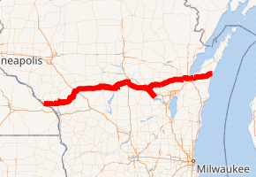
State Trunk Highway 54 (often called Highway 54, STH 54 or WIS 54) is a Wisconsin state highway running east–west across central Wisconsin. It is 243.12 miles (391.26 km) in length.
| ||||
|---|---|---|---|---|
WIS-54 highlighted in red | ||||
| Route information | ||||
| Maintained by WisDOT | ||||
| Length | 243.12 mi[1] (391.26 km) | |||
| Major junctions | ||||
| West end | ||||
| East end | ||||
| Location | ||||
| Counties | Buffalo, Trempealeau, Jackson, Wood, Portage, Waupaca, Outagamie, Brown, Kewaunee | |||
| Highway system | ||||
| ||||

Route description
The western terminus of Highway 54 is at the Minnesota state line at Winona, Minnesota on the North Channel Bridge. The eastern terminus is at Highway 42 in downtown Algoma at the corner of Jefferson and Lake Streets.
Major intersections
| County | Location | mi | km | Exit | Destinations | Notes |
|---|---|---|---|---|---|---|
| Buffalo | Town of Buffalo | 0.0 | 0.0 | Continuation into Minnesota | ||
| Western end of WIS 35 concurrency | ||||||
| Trempealeau | Town of Trempealeau | Eastern end of WIS 35 concurrency; western end of WIS 93 concurrency | ||||
| Galesville | Western end of US 53 concurrency | |||||
| Town of Gale | Eastern end of US 53/WIS 93 concurrency | |||||
| Jackson | Melrose | Western terminus of WIS 71; northern terminus of WIS 108 | ||||
| Black River Falls | Western end of US 12/WIS 27 concurrency | |||||
| Eastern end of US 12/WIS 27 concurrency | ||||||
| Exit 116 along I-94 | ||||||
| Wood | Dexter | Western end of WIS 80 concurrency | ||||
| Eastern end of WIS 80 concurrency | ||||||
| Port Edwards | Western end of WIS 73 concurrency | |||||
| Wisconsin Rapids | Eastern end of WIS 73 concurrency; western end of WIS 13 concurrency | |||||
| Eastern end of WIS 13 concurrency | ||||||
| Portage | Plover | Western end of Bus. US 51 concurrency | ||||
| Town of Plover | Southern terminus of Bus. US 51 | |||||
| Waupaca | Waupaca | Western end of US 10/WIS 49 concurrency | ||||
| 252 | Western end of WIS 22 concurrency | |||||
| Town of Waupaca | 253 | Churchill Street | ||||
| Waupaca | Eastern end of US 10/WIS 49 concurrency | |||||
| Royalton | Western end of WIS 110 concurrency | |||||
| Eastern end of WIS 22/WIS 110 concurrency | ||||||
| Outagamie | New London | Interchange | ||||
| Shiocton | Western end of WIS 76 concurrency | |||||
| Eastern end of WIS 76 concurrency | ||||||
| Southern terminus of WIS 187 | ||||||
| Black Creek | ||||||
| Seymour | Western end of WIS 55 concurrency | |||||
| Town of Oneida | Eastern end of WIS 55 concurrency | |||||
| Brown | Hobart | Roundabout; western terminus of WIS 172 | ||||
| Green Bay | Western end of WIS 32 concurrency | |||||
| — | Eastern end of WIS 32 concurrency; western end of freeway | |||||
| — | Broadway | Westbound exit and eastbound entrance | ||||
| — | Madison Street – Downtown | Eastbound exit and westbound entrance | ||||
| — | Western end of WIS 57 concurrency | |||||
| Western end of WIS 29 concurrency | ||||||
| Eastern end of WIS 29 concurrency | ||||||
| — | Western end of freeway | |||||
| — | University Avenue; Nicolet Drive | |||||
| — | ||||||
| — | Western end of WIS 57 concurrency; WIS 57 freeway continues north | |||||
| Kewaunee | Algoma | Eastern terminus | ||||
1.000 mi = 1.609 km; 1.000 km = 0.621 mi
| ||||||
Images
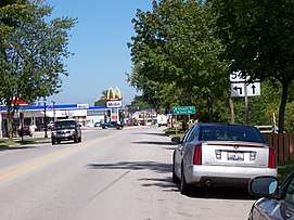 East terminus in Algoma
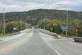 West terminus
gollark: jan Tajun.
gollark: The most fast, general, performant, elegant, readable, robust and well-tested one ever.
gollark: Design the ultimate dot product function.
gollark: ?
gollark: Do with this what you will.
References
- Bessert's, Christopher J. "Highways 50 through 59". Wisconsin Highways.
External links

This article is issued from Wikipedia. The text is licensed under Creative Commons - Attribution - Sharealike. Additional terms may apply for the media files.