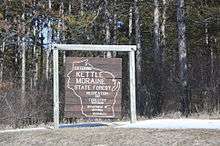
Kettle Moraine State Forest
The Kettle Moraine State Forest is a state forest in southeastern Wisconsin. The chief feature of the reserve is the Kettle Moraine, a highly glaciated area. The area contains very hilly terrain and glacial landforms, such as kettles, kames and eskers. The 56,000-acre (23,000 ha)[1] forest is divided into two large and three small units, which are spread across a hundred miles.
| Kettle Moraine State Forest | |
|---|---|
IUCN category V (protected landscape/seascape) | |
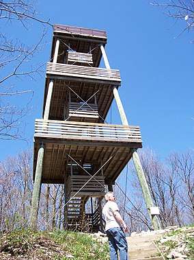 Parnell Observation Tower | |
| Location | Wisconsin, United States |
| Governing body | Wisconsin Department of Natural Resources |
The forest includes 250 miles (400 km) of hiking trails, almost 100 miles (160 km) of cross-country ski trails, 130 miles (210 km) of equestrian trails, 150 miles (240 km) of snowmobile trails, 75 miles (121 km) of off-road bicycle trails including 30 miles (48 km) of singletrack trail, and 750 campsites.[1]
All units include a portion of the Ice Age National Scenic Trail and most units have horse/snowmobile trails. Several areas of trail loops for hiking, biking and skiing can be found in the northern and southern units.
Kettle Moraine Scenic Drive is a 115-mile (185 km) scenic route that winds across southeastern Wisconsin, and through all five forest units.
Forest units
- The Northern Unit is located in western Sheboygan County, southeastern Fond du Lac County and northern Washington County. It is over twenty miles (32 km) long, and extends from just outside Glenbeulah, on the north end, southward to just east of Kewaskum. The Forest Headquarters is located in Campbellsport. Features of the Northern Unit are Greenbush Recreation Area, with a group camping area and hiking trails; Parnell Observation Tower; Long Lake Recreation Area, with a campground, a beach and boat launch; Henry S. Reuss Ice Age Visitor Center; Spruce Lake Bog; Saint John Evangelical Lutheran Church; and Mauthe Lake Recreation Area, with a campground.
- The Southern Unit extends from just west of North Prairie, southwestward to Whitewater Lake, south of Whitewater. Other nearby towns include Eagle and Palmyra. Features of the Southern Unit include Ottawa Lake Recreation Area which has boating, campgrounds and hiking and ski trails, and Whitewater Lake Recreation Area, which also features camping and boating. The Forest is host to Old World Wisconsin, a collection of farmsteads, recreating the homes and lives of settlers, and also to the McMiller Sportsmen Center, public hunting practice ranges.
- The Pike Lake Unit is on the eastern side of 446-acre (1.80 km2) Pike Lake. It is located on state Highway 60 in between Slinger and Hartford. The park offers camping, hiking, biking and swimming, and has an observation tower overlooking the park and lake.
- The Loew Lake Unit is a small recreation area located in the town of Erin, on the Oconomowoc River and Loews Lake in southwestern Washington County. It offers hiking, hunting and horse riding.
- Lapham Peak Unit is south of Delafield in Waukesha County. It has over 20 miles (32 km) of trails, and an observation tower.
- The Mukwanago River Unit is in Waukesha and Walworth Counties, adjacent to the Mukwonago River.[2]
See also
References
- McFadzen, Mike (December 2014). "The Kettle Moraine State Forest has the cure for cabin fever". Wisconsin Natural Resources. Wisconsin Department of Natural Resources: 4–6. Retrieved December 26, 2014.
- "Southern Kettle Moraine Waters Master Planning - Wisconsin DNR". Wisconsin Department of Natural Resources. Retrieved 2017-12-18.
External links
| Wikivoyage has a travel guide for Kettle Moraine State Forest. |
| Wikimedia Commons has media related to Kettle Moraine State Forest. |