Wisconsin Highway 441
State Trunk Highway 441, and often called the Tri-County Expressway or Highway 441 (STH 441, or WIS 441) is a state highway in the US state of Wisconsin. Together with Interstate 41/US Highway 41 (I-41/US 41), the highway forms a beltway around the greater Appleton area, and is a freeway for the entire length of its route. It connects at both ends to its parent highway, I-41/US 41. It runs east–west and north–south in east central Wisconsin from near Neenah around Appleton to near Little Chute through Winnebago, Outagamie and Calumet counties. The Roland Kampo Memorial Bridge spans Little Lake Butte des Morts near the highway's southwest terminus.
| ||||
|---|---|---|---|---|
| Tri-County Expressway | ||||
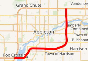
WIS 441 highlighted in red | ||||
| Route information | ||||
| Maintained by WisDOT | ||||
| Length | 10.88 mi[1] (17.51 km) | |||
| Existed | 1975–present | |||
| Major junctions | ||||
| South end | ||||
| North end | ||||
| Location | ||||
| Counties | Winnebago, Calumet, Outagamie | |||
| Highway system | ||||
| ||||

History

The Roland Kampo Memorial Bridge was the first portion of this road completed; traffic began flowing on the bridge at 11 a.m. on November 30, 1975.[1] The bridge, designated County Trunk Highway Q (CTH-Q) for its first years, extended from US 41 to CTH-P (Racine Road), approximately 1.3 miles (2.1 km). The bridge was also the last portion of the Tri-County Expressway completed for more than a decade, with the remainder of the expressway mired in the proposal stage. The exits were unsigned until 2019, when they were numbered to 441's mileage.
The bridge was given a state highway designation (WIS 441) in the 1980s, with signs to this effect going up in 1985 or 1986.[1] Movement to complete the full 10.88 miles (17.51 km) of freeway began in the late 1980s, and the first new stretch of freeway since 1975 was completed in November 1991, extending from CTH-P to US 10 (Oneida Street). The entire freeway length was completed in September 1993.[1]
Future
Between 2012 and 2019, the Wisconsin Department of Transportation (WisDOT) is working on expanding the route from east of I-41 to west of Calumet Street from four to six lanes along with upgrades of interchanges along the section. A large part of the work is completing the road's interchange with I-41 by installing missing ramps, adding auxiliary lanes to I-41 and upgrading the Kampo Memorial Bridge. Property was also acquired to allow the smoothing of two sharp curves from the Kampo Bridge to north of Midway Road, which allowed the speed limit for the entire length of WIS 441 to increase from 65 to 70 miles per hour (105 to 113 km/h).[2][3]
As part of the project, the existing interchange with Oneida Street was converted to a diverging diamond interchange; it opened on November 3, 2018 after being closed since August.[4][5]
Exit list
| County | Location | mi | km | Exit | Destinations | Notes |
|---|---|---|---|---|---|---|
| Winnebago | Fox Crossing | 0.0 | 0.0 | 287 | Western end of US 10 overlap; freeway uses US 10 mileposts and exit numbers | |
| Roland Kampo Memorial Bridge over Little Lake Butte des Morts | ||||||
| Menasha | 1.3 | 2.1 | 289A | |||
| 2.2 | 3.5 | 289B | ||||
| 3.2 | 5.1 | 290 | ||||
| Calumet | 4.2 | 6.8 | 291 | Eastern end of US 10 overlap; diverging diamond interchange | ||
| Outagamie | Appleton | 7.1 | 11.4 | 7 | ||
| Kimberly | 8.1 | 13.0 | 8 | |||
| Appleton | 10.1 | 16.3 | 10 | |||
| 10.7 | 17.2 | 11 | Signed as exits 11A (south) and 11B (north) | |||
1.000 mi = 1.609 km; 1.000 km = 0.621 mi
| ||||||
References
- Bessert, Chris. "Highways 400 through 894". Wisconsin Highways. Retrieved March 20, 2007.
- Wisconsin Department of Transportation (March 14, 2006). "US 10/WIS 441 Expansion Study". Wisconsin Department of Transportation. Archived from the original on December 7, 2006. Retrieved December 29, 2006.
- Wisconsin Department of Transportation. "WIS 441 Tri-County Project". Wisconsin Department of Transportation. Retrieved August 15, 2017.
- "Appleton's diverging diamond interchange opening on Saturday". WLUK. Retrieved November 12, 2018.
- "Last push to educate as Appleton's "diverging diamond" nears opening". WBAY-TV. October 26, 2018. Retrieved October 27, 2018.
External links
| Wikimedia Commons has media related to Wisconsin Highway 441. |