Wisconsin Highway 29
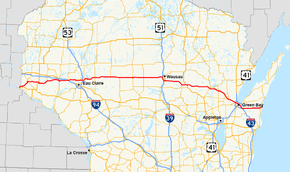
State Trunk Highway 29 (often called Highway 29, STH-29 or WIS 29) is a state highway running east–west across central Wisconsin. It is a major east–west corridor connecting the Twin Cities and the Chippewa Valley with Wausau and Green Bay. A multi-year project to upgrade the corridor to a four-lane freeway or expressway from Elk Mound to Green Bay was completed in 2005. The expansion served to improve safety on the route, which was over capacity as a two-lane road. The remainder of WIS 29 is two-lane surface road or urban multi-lane road.
| ||||
|---|---|---|---|---|
 | ||||
| Route information | ||||
| Maintained by WisDOT | ||||
| Length | 307.35 mi[1] (494.63 km) | |||
| Major junctions | ||||
| West end | ||||
| East end | ||||
| Location | ||||
| Counties | Pierce, St. Croix, Dunn, Chippewa, Clark, Marathon, Shawano, Brown, Kewaunee | |||
| Highway system | ||||
| ||||

Route description
Prescott to Elk Mound
WIS 29 begins at its western terminus at U.S. Highway 10 (US 10), on the north side of Prescott. From this point, WIS 29 follows WIS 35 northeast to River Falls, passing the University of Wisconsin–River Falls campus. At the junction with WIS 65, WIS 35 turns northbound with WIS 65 while WIS 29 continues east. WIS 29 joins briefly with US 63 west of Spring Valley[2] and turns eastbound upon its split one mile (1.6 km) south to head into Spring Valley.[3] Upon leaving Spring Valley and Pierce County, Wisconsin, the highway heads northwardward into St. Croix County and turns east towards Menomonie. WIS 29 does not pass through any municipalities while in this county, but it does cross WIS 128.[4]
Upon entering Dunn County, the route passes through rural terrain and enters Menomonie's west side as Hudson Road. The highway turns northward onto Main Street and passes west and north of the University of Wisconsin–Stout campus. WIS 29 turns east onto Stout Road along with US 12 and leaves the city to the east.[5] US 12/WIS 29 proceeds east for about nine miles (14 km) and junctions with Interstate 94 (I-94). This interchange is the westernmost point of the multi-lane WIS 29 corridor.[6] It is also the westernmost point of WIS 29 as a backbone route in Corridors 2020.[7]
Elk Mound to Wausau
West of County Highway T (CTH-T), the highway is an expressway. It passes into the Chippewa Valley metropolitan area and south of Chippewa Falls as a freeway and crosses US 53 at a cloverleaf interchange in Lake Hallie.[8] WIS 29 junctions with the southern terminus of WIS 178 southeast of Chippewa Falls then passes to the south of Lake Wissota State Park before crossing under WIS 27 in Cadott. WIS 29 passes south of Boyd and Stanley before exiting the county to the east.[8]
In Clark County, WIS 29 meets WIS 73 in Thorp. The two highways run concurrently and exit the village to the east, and WIS 73 splits to the south in Withee about 10 miles (16 km) east. WIS 29 continues east and passes south of Owen and Curtiss. At Abbotsford, WIS 29 and WIS 13 meet at a partial cloverleaf interchange between Abbotsford and Colby on the Clark–Marathon county line.[8] Twelve miles (19 km) east of Abbotsford, WIS 29 and WIS 97 meet at a diamond interchange. This is a key route for travelers between Wausau and Marshfield. East of this junction, WIS 29 follows a straight course that passes Edgar and meets WIS 107 at a diamond interchange on the north side of Marathon City, approximately eight miles (13 km) west of Wausau. WIS 29 enters Wausau as a freeway, junctions with the western terminus of WIS 52 approximately 1⁄2 mile (0.80 km) west of US 51 at an eastbound off/westbound on style half-interchange. WIS 29 then immediately enters the new US 51 interchange, and turns south onto and follows US 51 for five miles (8.0 km), bypassing the downtown area to the south.[9]
Wausau to Green Bay
South of Wausau, WIS 29 turns off US 51 to the east at the northern terminus of I-39 and continues as freeway, passing through the villages of Rothschild and Weston. The freeway section ends at Ringle. As an expressway, the highway passes just south of Hatley and turns southeast for about four miles (6 km) before turning east again at the northern terminus of WIS 49.[9]
The highway enters Shawano County about one mile (1.6 km) east of this junction.[9] WIS 29 passes north and around Wittenberg. US 45 joins with the highway north of Wittenberg and the two routes run concurrently to where US 45 splits to the south at about two miles (3.2 km) east of the village. WIS 29 bypasses Tilleda and Thornton on the way towards Shawano. At Shawano, the expressway becomes a freeway at the junction with CTH-MMM (WIS 29 Business) and turns southeast to bypass Shawano to the south, diamond interchanges link the highway with WIS 22 and WIS 47 north/WIS 55 north as it pass south of the city. WIS 47 south and WIS 55 south follow WIS 29 east. WIS 47 splits to the south at the diamond interchange junction with WIS 117 south of Bonduel. WIS 29 (along with WIS 55) then returns to an expressway at the junction with CTH-BE (WIS 29's former route). WIS 55 splits to the south at the diamond interchange junction with WIS 160 at Angelica and WIS 29 heads southeast to the Brown County line.[10]

About one mile (1.6 km) into Brown County, WIS 29 collects WIS 32 eastbound at the diamond interchange with WIS 156 and CTH-Y. WIS 29 very briefly passes through the northeast corner of Outagamie County and enters the village of Howard. The multilane expressway and the Backbone Corridor route end at Interstate 41/US 41.[7][11] WIS 32 turns south onto I-41/US 41 as WIS 29 continues into Green Bay as Shawano Avenue.[12]
Green Bay to Kewaunee
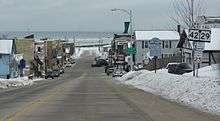
In downtown Green Bay, WIS 29 turns north onto South Monroe Avenue for four blocks, joining with WIS 54 and turns east onto Main Street, splitting from WIS 54 and joining US 141 to leave the city to the southeast. The highways pass over I-43 without an interchange. WIS 29 splits to the east from US 141 at about one mile (1.6 km) north of US 's southern terminus at I-43 in Bellevue. This provides the only access from I-43 to WIS 29. The highway passes through Poland and Henrysville as it exits Brown County to the east.[11] In Kewaunee County, WIS 29 passes due east through Pilsen and north of Krok as a two-lane road. The highway ends in downtown Kewaunee at WIS 42 on the shores of Lake Michigan.[13]
History
Prior to 1926, WIS 29 was numbered WIS 116 from Minnesota to Chippewa Falls, WIS 16 from Chippewa Falls to Bellevue, and WIS 146 from Bellevue to Kewaunee. WIS 16 continued southeast from Bellevue along what became US 141 in 1926 to Manitowoc. What had been WIS 29 before 1926 became US 16 across the state.[14]
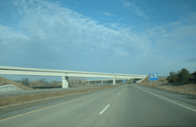
WIS 29 has long been known as "Bloody 29" because of the prevalence of grisly fatal traffic crashes along significant portions of the highway.[15] In 1988, a study was commissioned to examine upgrading the highway to a four-lane divided highway. The changes would be made along 203 miles (327 km) of road from I-94, 2 miles (3.2 km) west of Elk Mound, to US 41 in Howard (suburban Green Bay). The final segment of the highway, connecting the east side of Chippewa Falls with the segment running north of Eau Claire, was opened to traffic on August 16, 2005. Of the total length, about 65 miles (105 km) of the highway meets Interstate Highway standards.[16] Most of the expansion was completed with only minor additions to the already-existing easements, and as a result, the expanded roadway almost exactly matches the highway's original course.
The portion of WIS 29 between Chippewa Falls and Abbotsford roughly follows what used to be the Yellowstone Trail.[17][18]
Future
Long range plans call for WIS 29 to be converted to a full freeway between I-94 in Elk Mound and I-41 in Green Bay, however, there is no timetable for the entire corridor to be completed.[19]
Major intersections
| County | Location | mi | km | Exit[20] | Destinations | Notes |
|---|---|---|---|---|---|---|
| Pierce | Prescott | 0.00 | 0.00 | Western end of WIS 35 concurency | ||
| River Falls | Eastern end of WIS 35 concurrency | |||||
| Martell | ||||||
| St. Croix | Spring Valley | |||||
| Dunn | Menomonie | Western end of US 12 concurrency | ||||
| Elk Mound | 60 | Western end of four-lane expressway; signed as exits 60A and 60B | ||||
| 61 | Eastern end of US 12 concurrency | |||||
| Chippewa | Chippewa Falls | 69 | ||||
| 72 | ||||||
| 75 | Signed as exits 75A (US 53 south) and 75B (US 53 north) | |||||
| 79 | ||||||
| Lake Wissota | 80 | Westbound entrance and eastbound exit only | ||||
| 81 | ||||||
| 87 | Eastbound signage omits Lake Wissota State Park | |||||
| Cadott | 91 | |||||
| Boyd | 97 | |||||
| Stanley | 101 | |||||
| Clark | Thorp | 108 | ||||
| Withee | 118 | |||||
| Owen | 122 | |||||
| Curtiss | 127 | |||||
| Abbotsford | 131 | Eastbound exit and westbound entrance only | ||||
| Marathon | 132 | |||||
| 134 | Eastbound entrance and westbound exit only | |||||
| At-grade intersection | ||||||
| Wien | 145 | |||||
| At-grade intersection | ||||||
| Edgar | 150 | |||||
| At-grade intersection | ||||||
| Marathon City | 156 | |||||
| Wausau | 159 | |||||
| 162 | 72nd Avenue | |||||
| 164 | Northern end of US 51 concurrency; signed as exits 164A (WIS 52, Stewart Avenue) and 164B (US 51 north); signed as exit 192 on US 51; concurrency follows US 51's exit numbers | |||||
| 191 | Sherman Street | Northbound exit and southbound entrance only | ||||
| Town of Rib Mountain | 190 | |||||
| 188 | ||||||
| 170 | Southern end of US 51 concurrency; northern terminus of I-39; exit 187 on I-39/US 51 | |||||
| Rothschild | 171 | |||||
| Weston | 173 | |||||
| 177 | ||||||
| Ringle | 181 | |||||
| Hatley | 185 | |||||
| Elderon | At-grade intersection | |||||
| Shawano | Wittenberg | 195 | Western end of US 45 concurrency | |||
| 196 | Eastbound entrance and westbound exit only | |||||
| 198 | Easter end of US 45 concurrency; eastbound signage omits Bus. WIS 29, County Q, and Wittenberg | |||||
| At-grade intersection | ||||||
| Tilleda | At-grade intersection | |||||
| At-grade intersection | ||||||
| At-grade intersection | ||||||
| Thornton | At-grade intersection | |||||
| At-grade intersection | ||||||
| Shawano | 225 | |||||
| 227 | Western end of WIS 47/WIS 55 concurrency | |||||
| Bonduel | 234 | Eastern end of WIS 47 concurrency | ||||
| At-grade intersection; formerly WIS 29 | ||||||
| Angelica | At-grade intersection | |||||
| 242 | Eastern end of WIS 55 concurrency | |||||
| Brown | Oneida | 249 | Northwestern end of WIS 32 concurrency | |||
| At-grade J-turn (superstreet) intersection | ||||||
| Green Bay | At-grade J-turn (superstreet) intersection | |||||
| 255 | ||||||
| Eastbound exit, westbound entrance | ||||||
| Southwestern end of WIS 32 concurrency; exit 169 on US 41; eastern end of WIS 32 expressway | ||||||
| Western end of US 141 concurrency | ||||||
| Bellevue | Eastern end of US 141 concurrency | |||||
| Poland | ||||||
| Henrysville | ||||||
| Kewaunee | Pilsen | |||||
| Stangelville | Former WIS 163 | |||||
| Kewaunee | Eastern terminus | |||||
1.000 mi = 1.609 km; 1.000 km = 0.621 mi
| ||||||
Business routes
WIS 29 has four business routes:
- Business WIS 29 in Chippewa Falls
- Business WIS 29 in Abbotsford
- Business WIS 29 in Wittenberg
- Business WIS 29 in Shawano
See also

References
- Federal Highway Administration. "The National Highway Planning Network". Federal Highway Administration. Retrieved September 2, 2007.
- Google (December 25, 2007). "US 63 to US 63" (Map). Google Maps. Google. Retrieved December 25, 2007.
- Wisconsin Department of Transportation. Pierce Co (PDF) (Map). 1:100,000. Madison: Wisconsin Department of Transportation. Archived from the original (PDF) on May 16, 2008. Retrieved December 25, 2007.
- Wisconsin Department of Transportation. St. Croix Co (PDF) (Map). 1:100,000. Madison: Wisconsin Department of Transportation. Retrieved December 25, 2007.
- Google (December 25, 2007). "Hudson Road, Menomonie, Wisconsin" (Map). Google Maps. Google. Retrieved December 25, 2007.
- Wisconsin Department of Transportation. Dunn Co (PDF) (Map). 1:100,000. Madison: Wisconsin Department of Transportation. Retrieved December 25, 2007.
- "Wisconsin State Highway Plan 2020 Summary Report" (PDF). Wisconsin Department of Transportation. Wisconsin Bureau of Planning. Retrieved October 5, 2016.
- Wisconsin Department of Transportation. Chippewa Co (PDF) (Map). 1:100,000. Madison: Wisconsin Department of Transportation. Retrieved December 25, 2007.
- Wisconsin Department of Transportation. Marathon Co (PDF) (Map). 1:100,000. Madison: Wisconsin Department of Transportation. Retrieved December 25, 2007.
- Wisconsin Department of Transportation. Shawano Co (PDF) (Map). 1:100,000. Madison: Wisconsin Department of Transportation. Archived from the original (PDF) on August 15, 2011. Retrieved December 25, 2007.
- Wisconsin Department of Transportation. Brown Co (PDF) (Map). 1:100,000. Cartography by WisDOT. Wisconsin Department of Transportation. Archived from the original (PDF) on April 13, 2007. Retrieved December 25, 2007.
- Google (December 25, 2007). "Shawano Ave, Green Bay" (Map). Google Maps. Google. Retrieved December 25, 2007.
- Wisconsin Department of Transportation. Kewaunee Co (PDF) (Map). 1:100,000. Madison: Wisconsin Department of Transportation. Retrieved December 25, 2007.
- Bauer, Kurt W. (1969). "Map 5: Original State Trunk Highway System in Wisconsin 1918" (Map). A Jurisdictional Highway System Plan For Milwaukee County. Scale not given. Milwaukee: Southeast Wisconsin Regional Planning Commission. OCLC 226912. Retrieved January 10, 2008 – via Midwest Roads.
- Bessert, Christopher J. "Highways 20-29". Retrieved February 3, 2012.
- Wisconsin Department of Transportation. "WIS 29 Freeway Conversion Study". Wisconsin Department of Transportation. Retrieved June 10, 2007.
- "The Yellowstone Trail in Chippewa County Wisconsin". Yellowstone Trail Association. Retrieved December 25, 2007.
- "The Yellowstone Trail in Clark County Wisconsin". Yellowstone Trail Association. Retrieved December 25, 2007.
- (PDF) https://wisconsindot.gov/Documents/projects/multimodal/conn2030/2030-9.pdf. Retrieved July 14, 2020. Missing or empty
|title=(help) - Wisconsin Department of Transportation. "Exit Numbers on WIS 29". Wisconsin Department of Transportation. Retrieved June 10, 2007.
External links
