Greater Philippines
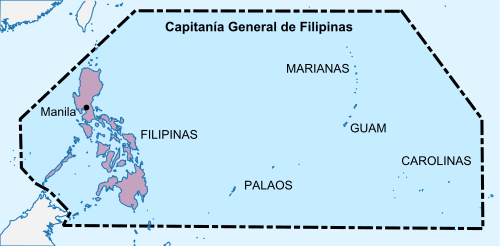
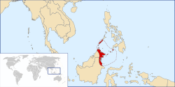
Greater Philippines (Spanish: La Gran Filipinas) is an irredentist concept in the Philippines supporting the inclusion of the Spanish East Indies and eastern Sabah as a part of the country's territory. The term may also extend to various other proposed scenarios that include any or all of the following: Scarborough Shoal, the Macclesfield Bank, and the Spratly Islands (officially claimed by the government as the Kalayaan Islands).
Areas under the concept

Spanish East Indies
All the territories belonging to the Spanish East Indies which includes the Philippines, Guam, and several Pacific island nations.
Philippine Archipelago
The Philippine Archipelago is the core component of Greater Philippines. As described in Article 1 of the 1987 Constitution, the Philippine Archipelago is part of Philippine territory.[1] This provision has appeared in the 1935 Philippine Constitution [2] for the first time, since the 1899 Malolos Constitution has specified only the areas under Spanish control, including the rest of the Spanish East Indies.[3]
Benham Rise
The Benham Rise (called by the Manila the "Philippine Rise"[4]) is a seismically active undersea region and extinct volcanic ridge located in the Philippine Sea approximately 250 km (160 mi) east of the northern coastline of Dinapigue, Isabela. The UN officially approved the Philippines' territorial claim to the Benham Plateau in April 2012.[5]
Spratly/Kalayaan Islands
The Philippine claim for the Spratly Islands was based on the voyage and the annexation of Admiral Tomás Cloma, Sr., who relinquished all his rights to the Philippine government in the 1970s.The claim for the Kalayaan group was enshrined in the 1973 Philippine Constitution and in later versions.
Scarborough Shoal
The Philippine government also claims Scarborough Shoal, which it calls "Bajo de Masinloc and Panatag Shoal, as part of its territory, citing its position within the country's Exclusive Economic Zone.[6] The Philippines places the shoal under the jurisdiction of Masinloc, Zambales, which is on the Luzon mainland 124 nautical miles to the east.
Macclesfield Bank
Macclesfield Bank, located east of the Paracel Islands, distantly southwest of the Pratas Islands and north of the Spratly Islands, is claimed by China[7] and Taiwan (Republic of China).[8][9]
Some sources[9][10] state that the Philippines claims this underwater feature. Philippine Ambassador Jose Zaide, however wrote that the Philippines does not claim the Macclesfield Bank.[11]
North Borneo
Sultanate of Sulu

Between 1658 and 1700s, the Sultanate of Sulu acquiring the eastern part of the territory of northern Borneo after helping the Bruneian forces in settling a civil war. The Sulu Archipelago then came under the control of Spanish, while the area in northern Borneo was administered by the British. Under a series of agreements between the Sultanate of Brunei and Sulu, both the sultans agreed to ceded their control on west and eastern part of northern Borneo to the British in which it became known as North Borneo.[14][15]
In a process of decolonisation since 1946, Great Britain included Sabah in the newly formed Federation of Malaysia. The Philippines (who already achieved its independence from the United States) under the administration of President Diosdado Macapagal however protested the formation of Malaysia and filed claims to the whole territory of northern Borneo. Meanwhile, during a meeting of Maphilindo, the Philippines government said they had no objection to the formation of Malaysia but said the Sultan of Sulu wanted the payment of 5,000 although the British government never paid any compensation to the Sultanate.[16] The first Malaysian Prime Minister at the time, Tunku Abdul Rahman said he would go back to Kuala Lumpur and get back to them on the claim.[16]
The situation became worse under the administration of the then Philippine President Ferdinand Marcos who then revive the claim and train a number of Moro fighters to reclaim the territory under a secret mission called "Operation Merdeka". But upon the recruits realising their true mission, most of them demanded to be return home as they did not want to kill their fellow Muslim brothers in Sabah. But Marcos soldiers did not sent them back instead execute most of the fighters in an event known as Jabidah massacre.[17] The tragedy has caused the South Philippines insurgency to emerged and the claim have been escalate by other new claimants from the defunct Sultanate of Sulu, mostly self-proclaim themselves as a new Sultan of Sulu with a support from politicians in the Philippine central government to take Sabah as part of the Philippines territory. Most new claimants and several Philippine politicians today using the Malaysian payment of 5,000 as their main excuse to overtake the territory as well using it as a reason on the International Court of Justice (ICJ).[16]
Manila Accord
During the formation of Malaysia, the Federation of Malaya signed the Manila Accord along with the Malaysia Act 1963.[18] These acts solidified the position regarding claim of North Borneo by the Philippines following the establishment of Malaysia.[19]
Per international law, the Malayan government,[19] as a predecessor state to Malaysia, agreed to abide by the wishes of the peoples of North Borneo and Sarawak within the context of United Nations General Assembly Resolution 1541 (XV), Principle 9 of the Annex, which was created to complete compliance with the principle of self-determination.[20][21] International law also took into account referendums in North Borneo and Sarawak that would be free and without coercion.[22]
Territories claimed by the Philippines
The Philippines has claimed many territories throughout its history. These territories include the Spratly Islands, Sabah, Scarborough Shoal, Palmas (Miangas), Orchid Island, the Sangir Islands, the Marianas Islands, and the Caroline Islands.
See also
References
- "[ 1987 CONSTITUTION, February 02, 1987 ]". Philippine Supreme Court E-Library. 2 February 1987. Retrieved 8 June 2019.
- "[ 1935 CONSTITUTION, May 14, 1935 ]". Philippine Supreme Court E-Library. 14 May 1935. Retrieved 8 June 2019.
- "[ MALOLOS CONSTITUTION, January 20, 1890 ]". Philippine Supreme Court E-Library. 20 January 1890. Retrieved 8 June 2019.
- "[ EXECUTIVE ORDER NO. 25, May 16, 2017 ]". Philippine Supreme Court E-Library.
- UN approves PH territorial claim to Benham Rise, April 28, 2012, Philippine Daily Inquirer.
- The Hague (July 12, 2016). "PRESS RELEASE--The South China Sea Arbitration" (PDF). pca-cpa.org. Archived from the original (PDF) on July 12, 2016. Retrieved January 22, 2019.
- "Vietnam Law on Contested Islands Draws China's Ire". The New York Times. June 21, 2012. Retrieved June 28, 2012.
- "Taiwan renews sovereignty claim over South China Sea islands". Focus Taiwan. May 5, 2012. Retrieved June 28, 2012.
- "Limits in the Seas - No. 127 Taiwan's Maritime Claims" (PDF). United States Department of State. November 15, 2005. Retrieved July 1, 2012.
- "Philippines protests China's moving in on Macclesfield Bank". Inquirer.net. July 6, 2012. Retrieved July 6, 2012.
- Zaide, Jose (July 10, 2012). "Saan Siya?". Manila Bulletin. Archived from the original on January 13, 2013. Retrieved 31 October 2012.
- "British North Borneo company charter (page 4)". OpenLibrary.org. 1878. Retrieved 29 July 2013.
- Mohamad, Kadir (2009). "Malaysia's territorial disputes – two cases at the ICJ : Batu Puteh, Middle Rocks and South Ledge (Malaysia/Singapore), Ligitan and Sipadan [and the Sabah claim] (Malaysia/Indonesia/Philippines)" (PDF). Institute of Diplomacy and Foreign Relations (IDFR) Ministry of Foreign Affairs, Malaysia: 46. Archived from the original (PDF) on 16 May 2016. Retrieved 16 May 2014.
Map of British North Borneo, highlighting in yellow colour the area covered by the Philippine claim, presented to the Court by the Philippines during the Oral Hearings at the ICJ on 25 June 2001
Cite journal requires|journal=(help) - Rozan Yunos (21 September 2008). "How Brunei lost its northern province". The Brunei Times. Archived from the original on 17 June 2014. Retrieved 28 October 2013.
- Rozan Yunos (7 March 2013). "Sabah and the Sulu claims". The Brunei Times. Archived from the original on 17 June 2014. Retrieved 20 September 2013.
- "Why 'Sultan' is dreaming". Daily Express. 27 March 2013. Archived from the original on 28 March 2013. Retrieved 27 March 2013.
- Paul F. Whitman (2002). "The Corregidor Massacre - 1968". Corregidor Historic Society. Archived from the original on 13 September 2015. Retrieved 13 September 2015.
- Malaysia Act 1963 Archived 2012-11-14 at the Wayback Machine
- United Nations Press Release United Nations Member States
- General Assembly 15th Session – The Trusteeship System and Non-Self-Governing Territories (pages:509–510) Archived 2012-03-20 at the Wayback Machine
- General Assembly 18th Session – the Question of Malaysia (pages:41–44) Archived 2011-11-11 at the Wayback Machine
- Noble, Lela Garner; Thames, John L. (1977). Philippine policy toward Sabah: a claim to independence. University of Arizona Press. p. 267. ISBN 978-0816505982.