Kyle of Sutherland
The Kyle of Sutherland (Scottish Gaelic: An Caol Catach) is a river estuary that separates Sutherland from Ross-shire. It flows into the Dornoch Firth and is fed by the rivers Oykel, Shin, River Cassley and Carron.
| Kyle Of Sutherland | |
|---|---|
| "The Kyle" | |
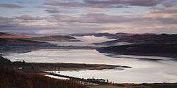 | |
| Location | From Rosehall to Bonar Bridge |
| Coordinates | 57°55.5′N 4°24′W |
| Type | Estuary |
| Primary inflows | River Carron, Loch Shin, River Cassley, River Oykel |
| Primary outflows | Dornoch Firth |
| First flooded | January 29, 1892 |
| Settlements | Bonar Bridge, Ardgay, Rosehall, Culrain |
The downstream extent[1] of the Kyle of Sutherland is the eponymous bridge at Bonar Bridge. The upstream end of 'the Kyle' as it is locally known, is the furthest inland extent of tidal water,[2] which corresponds to 'the bailey bridge', beyond Rosehall.
The Kyle did separate Sutherland and Ross-shire for centuries until 1975[3][4][5] when the old Scottish counties were abolished. The counties of Sutherland and Ross became districts of the Highland Region, with altered boundaries. As a result of this, the Kyle became wholly part of Sutherland, though most locals continue to refer to the original boundaries.
1892 flooding
| Date | January 29, 1892 |
|---|
The first Bonar Bridge was built in 1812 after the Battle of Culloden; it was engineered by Thomas Telford. Eighty years later, the bridge was swept away by a flood on 29 January 1892, a winter of many great floods in the North of Scotland. It has been suggested that this event was predicted by the Brahan Seer.
References
- http://t2.gstatic.com/images?q=tbn:ANd9GcR5AnN_kjx8qtKlByQbVpJhhQG0qyPpiAO2DWdDI4F4Di25oVznmw map of the lower Kyle of Sutherland
- http://www.trout-salmon-fishing.com/scotland-kyle-sutherland.htm Fishing website
- Counties of Scotland#Reform Counties & reorganisation
- Local government areas of Scotland 1973–96 Re-organisation to create Highland Region
- http://p4modeller.wordpress.com/2-kyle-of-sutherland/ note of county boundary changes
| Wikimedia Commons has media related to Kyle of Sutherland. |